geo.wikisort.org - Mountains
Ostler Peak is a 12,718-foot elevation (3,876 m) mountain summit located in Summit County, Utah, United States.
| Ostler Peak | |
|---|---|
 North aspect | |
| Highest point | |
| Elevation | 12,718 ft (3,876 m)[1] |
| Prominence | 1,158 ft (353 m)[2] |
| Parent peak | Lamotte Peak (12,720 ft)[3] |
| Isolation | 2.07 mi (3.33 km)[3] |
| Coordinates | 40°44′48″N 110°46′08″W[4] |
| Naming | |
| Etymology | Dick Ostler |
| Geography | |
 Ostler Peak Location in Utah  Ostler Peak Ostler Peak (the United States) | |
| Location | High Uintas Wilderness |
| Country | United States of America |
| State | Utah |
| County | Summit |
| Parent range | Uinta Mountains Rocky Mountains |
| Topo map | USGS Hayden Peak |
| Geology | |
| Age of rock | Neoproterozoic |
| Type of rock | Metasedimentary rock |
| Climbing | |
| Easiest route | class 2 scrambling[3] |
Description
Ostler Peak is set within the High Uintas Wilderness on land managed by Uinta-Wasatch-Cache National Forest. It is situated along the crest of the Uinta Mountains which are a subset of the Rocky Mountains, and it ranks as the 37th-highest summit in Utah.[5] Topographic relief is significant as the summit rises over 1,900 feet (580 meters) above Amethyst Lake in one-half mile. Neighbors include Spread Eagle Peak 1.4 mile to the southwest, Hayden Peak four miles west, and line parent Lamotte Peak two miles north-northeast. Precipitation runoff from this mountain drains into the Ostler and Stillwater forks of the Bear River.
Etymology
The landform's toponym was officially adopted in 1932 by the U.S. Board on Geographic Names to remember the late James Rulon "Dick" Ostler (1900–1931), Uinta National Forest ranger in the Grandaddy Lake region of the Uinta Mountains.[4][6]
Climate
Based on the Köppen climate classification, Ostler Peak is located in a subarctic climate zone with cold snowy winters and mild summers.[7] Tundra climate characterizes the summit and highest slopes.
Gallery
 Ostler Peak and Spread Eagle Peak seen from Christmas Meadows
Stillwater Fork of the Bear River in foreground Ostler Peak and Spread Eagle Peak seen from Christmas Meadows
 Ostler Peak in autumn
 Amethyst Lake viewed from Ostler Peak
 Lamotte Peak (left), Ostler Peak (center), Spread Eagle Peak (right).
 Ostler Peak in autumn
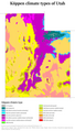 Köppen climate types of Utah with Uinta Mountains shown in dark green


See also
- Geology of the Uinta Mountains
- List of mountains in Utah
 Mountains portal
References
- United States Geological Survey topographical map - Hayden Peak
- "Ostler Peak, Utah". Peakbagger.com. Retrieved 2022-08-04.
- "Ostler Peak - 12,718' UT". listsofjohn.com. Retrieved 2022-08-04.
- "Ostler Peak". Geographic Names Information System. United States Geological Survey, United States Department of the Interior. Retrieved 2022-08-04.
- Utah 12,000-foot Peaks, peakbagger.com
- John W. Van Cott (1990), Utah Place Names, University of Utah Press, ISBN 9780874803457, p. 283
- Peel, M. C.; Finlayson, B. L. & McMahon, T. A. (2007). "Updated world map of the Köppen−Geiger climate classification". Hydrol. Earth Syst. Sci. 11 (5): 1633–1644. Bibcode:2007HESS...11.1633P. doi:10.5194/hess-11-1633-2007. ISSN 1027-5606. S2CID 9654551.
External links
- Ostler Peak: weather forecast
- Ostler Peak (photo): Flickr
Другой контент может иметь иную лицензию. Перед использованием материалов сайта WikiSort.org внимательно изучите правила лицензирования конкретных элементов наполнения сайта.
WikiSort.org - проект по пересортировке и дополнению контента Википедии