geo.wikisort.org - Mountains
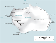
Olavtoppen,[1][2] occasionally anglicised as Olav Peak, is the highest point of Bouvet Island, a volcanic island and dependency of Norway, and the remotest island on Earth. Olavtoppen is located north of the center of the island, immediately south of Kapp Valdivia, and rises 780 meters (2,560 ft) above mean sea level.[1] It was first ascended on 21 February 2012 by Aaron Halstead, Will Allen, Bruno Rodi, Johan Llwyd, and Jason Rodi[3]
References
- Barr, Susan (1987). Norway's Polar Territories. Oslo: Aschehoug. p. 59. ISBN 82-03-15689-4.
- P. E. Baker (1967). "Historical and Geological Notes on Bouvetøya" (PDF). British Antarctic Survey Bulletin (13): 71–84. Archived from the original (PDF) on 16 March 2012. Retrieved 8 May 2012.
- Rubin, Jeff (2005). Antarctica. Lonely Planet. p. 155. ISBN 1-74059-094-5. - Jason Rodi: Making History – Summiting of the most remote land on Earth
This Bouvet Island location article is a stub. You can help Wikipedia by expanding it. |
This Norway mountain, mountain range, or peak related article is a stub. You can help Wikipedia by expanding it. |
На других языках
[de] Olavtoppen
Olavtoppen (norwegisch, auch bekannt als Kaiser Wilhelm Pik[2]) ist mit 780 m Höhe der höchste Gipfel der zu Norwegen gehörenden Bouvetinsel im südatlantischen Ozean. Der Gipfel liegt auf dem nordöstlichen Kraterrand der Vulkaninsel und ist wie 93 % der Fläche der Insel vergletschert. Etwa zwei Kilometer nördlich des Gipfels liegt das Kap Valdivia, der nördlichste Punkt der Insel.- [en] Olavtoppen
Текст в блоке "Читать" взят с сайта "Википедия" и доступен по лицензии Creative Commons Attribution-ShareAlike; в отдельных случаях могут действовать дополнительные условия.
Другой контент может иметь иную лицензию. Перед использованием материалов сайта WikiSort.org внимательно изучите правила лицензирования конкретных элементов наполнения сайта.
Другой контент может иметь иную лицензию. Перед использованием материалов сайта WikiSort.org внимательно изучите правила лицензирования конкретных элементов наполнения сайта.
2019-2026
WikiSort.org - проект по пересортировке и дополнению контента Википедии
WikiSort.org - проект по пересортировке и дополнению контента Википедии