geo.wikisort.org - Mountains
Ograzhden (Огражден, pronounced [oˈɡraʒdɛn]) in Bulgarian and [ˈɔɡraʒdɛn] (![]() listen) in Macedonian) is a mountain range shared by southwestern Bulgaria and southeastern North Macedonia. The highest peak of the mountain is located in North Macedonia, Ograzhdenets (Огражденец) at 1,744 m, while the highest in Bulgaria is Bilska Chuka (Билска чука) at 1,644 m.[1]
listen) in Macedonian) is a mountain range shared by southwestern Bulgaria and southeastern North Macedonia. The highest peak of the mountain is located in North Macedonia, Ograzhdenets (Огражденец) at 1,744 m, while the highest in Bulgaria is Bilska Chuka (Билска чука) at 1,644 m.[1]
| Ograzhden | |
|---|---|
| Bulgarian: Огражден | |
 Ograzhden seen from Bilska Chuka, Bulgaria | |
| Highest point | |
| Peak | Ograzhdenets |
| Elevation | 1,744 m (5,722 ft) |
| Coordinates | 41°30′30.96″N 23°0′26.28″E |
| Geography | |
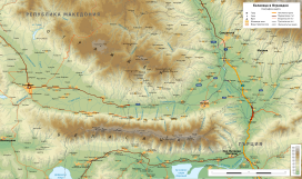 Map of the mountains of Ograzhden (north) and Belasitsa (south)
| |
| Country | Bulgaria, North Macedonia |
Geography
Ograzhden is part of the Belasitsa-Osogovo mountain group. To the north the valley of the river Lebnitsa (right tributary of the Struma) separates it from the Maleshevo Mountain; and to the southwest, south and southeast its slopes descend steeply to the Strumitsa and Sandanski–Petrich Valleys, north of the Belasitsa mountain range. To the west the valley of the river Turia (left tributary of Strumeshnitsa) separates it from Dragolevska Mountain. East of the Struma river lies the Pirin mountain range.[1] The main ridge of Ograzhden stretches from west to east for about 50 km, and its width reaches 17 km.
The main mountain ridge is wide and flat with an average altitude of 1200 m and is stemmed by a number of secondary ridges. The highest summit of the mountain is Ograzhdenets at 1744 m, located in North Macedonia, about 3 km west of the border. In the Bulgarian part the highest peak is Bilska Chuka 1644 m, about 2 km north of the village of Baskaltsi.[1] To the east-southeast of the summit rises the peak Markovi Kladentsi (1523 m) with a panoramic view in all directions. Other summits include: Golak (1639 m), Muratov Vrah (1398 m) and Kukovski Chukar (1233 m).
Ograzhden is formed by broken metamorphic rocks[1] — gneiss and various types of schists, which are easily susceptible to weathering and erosion. At its southern foothills there are deluvial deposits with a thickness of 10—20 m.
Climate and water
The climate of the mountain is transitional Mediterranean. Its whole territory falls into the catchment area of the river Struma. The northern slopes are drained by small and short right tributaries of the river Lebnitsa; the eastern by streams flowing directly into the Struma; and southern and western are drained by left tributaries of the river Strumeshnitsa.[1]
Trivia
Ograzhden Cove in Livingston Island in the South Shetland Islands, Antarctica is named after Ograzhden Mountain.
Gallery
 View of Ograzhden from Belasitsa, Bulgaria
 Village of Gega, Bulgaria in Ograzhden
 Churilovo Monastery in Ograzhden, Bulgaria
 Markovi Kladentsi peak, Bulgaria


Citations
References
- Мичев (Michev), Николай (Nikolay); Михайлов (Mihaylov), Цветко (Tsvetko); Вапцаров (Vaptsarov), Иван (Ivan); Кираджиев (Kiradzhiev), Светлин (Svetlin) (1980). Географски речник на България [Geographic Dictionary of Bulgaria] (in Bulgarian). София (Sofia): Наука и култура (Nauka i kultura).
На других языках
- [en] Ograzhden (mountain)
[fr] Ograjden (massif)
L'Ograjden (en bulgare et en macédonien, Огражден) est un massif montagneux situé sur la frontière entre la Bulgarie et la Macédoine du Nord. La partie bulgare est incluse dans l'oblast de Blagoevgrad et la partie macédonienne dans la région du Sud-Est. Le massif est bordé par les villes de Stroumitsa et de Petritch et son point culminant, l'Ograjdenets, situé dans sa partie macédonienne, atteint 1 744 mètres d'altitude[1].[ru] Огражден
О́гражден — горы на юго-востоке Северной Македонии и юго-западе Болгарии, часть из горной цепи Беласица. Расположены к северу от Беласицы, к северо-востоку от северомакедонского города Струмица и к северо-западу от болгарского города Петрич. Самым высоким пиком в Северной Македонии является Ограженец (1744 метра), а самая высокая гора в Болгарии от этой цепи — Билска Чука (1644 метра).Другой контент может иметь иную лицензию. Перед использованием материалов сайта WikiSort.org внимательно изучите правила лицензирования конкретных элементов наполнения сайта.
WikiSort.org - проект по пересортировке и дополнению контента Википедии