geo.wikisort.org - Mountains
Nyamuragira, also known as Nyamulagira, is an active shield volcano in the Virunga Mountains of the Democratic Republic of the Congo, situated about 25 kilometres (16 mi) north of Lake Kivu. The name is derived from the Bantu verb Kuragira nyamu, meaning to herd animals; nyamu means animal or cows.[citation needed]
| Nyamuragira | |
|---|---|
 Nyamuragira (left) and Nyiragongo (right). Vertical scale exaggerated (1.5×). | |
| Highest point | |
| Elevation | 3,058 m (10,033 ft)[1] |
| Prominence | 784 m (2,572 ft) |
| Coordinates | 1°24′29″S 29°12′00″E[1] |
| Geography | |
 Nyamuragira Democratic Republic | |
| Location | Nord-Kivu, Democratic Republic of the Congo |
| Parent range | Virunga Mountains |
| Geology | |
| Mountain type | Shield volcano |
| Last eruption | April 2018-Present[when?] |
It has been described as Africa's most active volcano[2] and has erupted over 40 times since 1885.[3] As well as eruptions from the summit, there have been numerous eruptions from the flanks of the volcano, creating new smaller volcanoes that have lasted only for a short time (e.g. Murara from late 1976 to 1977).
Recent eruptions occurred on 2 January 2010,[3] 8 November 2011[citation needed] and 23 May 2021.[4]
Geography and geology
Nyamuragira volcano is an active volcano near the city of Goma in the Democratic Republic of the Congo, situated about 25 kilometres (16 mi) north of Lake Kivu. It is in the Nord-Kivu Province. It is 13 kilometres (8.1 mi) north-north-west of Nyiragongo, the volcano which caused extensive damage to the city of Goma in its 2002 eruption.
Nyamuragira has a volume of 500 cubic kilometres (120 cu mi), and covers an area of 1,500 square kilometres (580 sq mi). It has a low shield profile and contrasts with adjacent steep-sided Nyiragongo volcano.
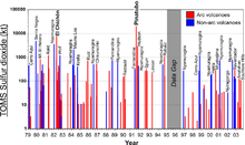
Nyamuragira volcano is responsible for a large portion of the sulfur dioxide released into the atmosphere by volcanoes.

Recent activity
2010 eruption
At dawn on 2 January 2010 Nyamuragira began spewing out lava flows. There are no settlements close to the volcano, but wildlife officials feared that the eruption may threaten the chimpanzees in the area. Another danger was that the lava could have flowed into the southern sector of Virunga National Park, where there are settlements and villages.[5]
Extensive lava flows from the 2010 eruption can be seen on satellite photographs[6] reaching 25 kilometres (16 mi) south-west to Lake Kivu, about 22 kilometres (14 mi) north-west and 35 kilometres (22 mi) north-north-east.
2011 eruption
The volcano erupted again on 5 November 2011.[7]
That eruption produced a 400-metre (1,300 ft) high column of lava, and it is said to have been its largest eruption in 100 years.[8]
2014 lava lake

In 2014, a new lava lake appeared at the volcano for the first time in 75 years. The previous lava lake at the volcano was emptied in the 1938 lava flow. The formation of the new lake occurred between June and August 2014.[9] It reached a depth of 500 metres (1,600 ft)}. The eruption did not affect the communities in the area but left a lot of ash and air pollution. Sulfate aerosols formed by volcanic sulfur dioxide from the eruptions were observed as far away as over the central Amazon rain forest in South America.[10] By 2018, the lava lake had hardened and the activity appeared to have stopped. Eruptive activity continues during 2021 at the summit caldera. [11]
2021 lava lake
In 2021, a lava lake appeared at the volcano based on a June 11 satellite image.[12]
See also
References
- "Nyamuragira". Global Volcanism Program. Smithsonian Institution. Retrieved 2 March 2020.
- Smets, B.; Wauthier, C.; d’Oreye, N. (2010), "A new map of the lava flow field of Nyamulagira (D.R. Congo) from satellite imagery", Journal of African Earth Sciences, 58 (5): 778–786, Bibcode:2010JAfES..58..778S, doi:10.1016/j.jafrearsci.2010.07.005
- "Volcano erupts in Congo". CNN. 2 January 2010. Retrieved 13 February 2011.
- "Mount Nyiragongo: DR Congo residents flee as volcano erupts". BBC News. 23 May 2021.
- "DR Congo Volcano Eruption Threatens Rare Chimpanzees". BBC News. 2 January 2010. Retrieved 2 January 2010.
- Google Earth Archived 8 September 2010 at the Wayback Machine shows the crater and lava flows very clearly at coordinates -1.408333, 29.200000
- "Congo Volcano Erupts: Video". The Guardian. 8 November 2011. Retrieved 8 November 2011.
- "Nyamuragira Volcano, Democratic Republic of the Congo". Volcano Photos. Geographic.org. Retrieved 26 December 2011.
- "New Lava Lake Appears Atop African Volcano". iflscience. Retrieved 15 November 2017.
- Saturno, Jorge; et al. (2018), "African volcanic emissions influencing atmospheric aerosols over the Amazon rain forest" (PDF), Atmospheric Chemistry and Physics, 18 (5): 10391–10405, Bibcode:2018ACP....1810391S, doi:10.5194/acp-18-10391-2018
- "Volcano on the Brink". PBS. Retrieved 27 November 2018.
- "Nyamuragira volcano (DRCongo): new lava lake". www.volcanodiscovery.com. Retrieved 2 November 2021.
External links
- Nyamuragira Volcano
- Smithsonian Institution's Global Volcanism Program: Nyamuragira
- 2006 eruption
- "Congo volcano threat to villages" BBC report with video, 2010 eruption
- "Nyamuragira volcano - VolcanoDiscovery" Information, news, videos and photos from the 2011-2012 eruption
- VolcanoDiscovery news
Authority control | |
|---|---|
| General |
|
| National libraries | |
На других языках
[de] Nyamuragira
Der Nyamuragira (auch Girungo-Namlagira, Namlagira, Nyamlagira oder Nyamulagira)[1] ist ein aktiver Vulkan innerhalb der Virunga-Vulkankette im Osten der Demokratischen Republik Kongo. Der Vulkan liegt etwa 25 Kilometer nördlich des Kiwusees und der Stadt Goma in der Nähe zur Grenze nach Ruanda.- [en] Nyamuragira
[es] Monte Nyamuragira
El Nyamuragira, o Volcán Nyamuragira,[1] también llamado Girungo-Namlagira, Namlagira, Nyamlagira o con más frecuencia Nyamulagira,[2]es un volcán de la República Democrática del Congo.[3] El volcán más activo de África, es capaz de producir lava que llega hasta una distancia de treinta kilómetros de longitud y hasta cerca del lago Kivu.[3] Entró en erupción el 22 de junio de 2014.[4][fr] Nyamuragira
Le Nyamuragira, également appelé Girungo-Namlagira, Namlagira, Nyamlagira ou plus fréquemment Nyamulagira[1], est un volcan de la République démocratique du Congo[2]. Volcan le plus actif d'Afrique, il est capable de produire des coulées de lave de plus de trente kilomètres de longueur qui atteignent ainsi le lac Kivu[2].[it] Nyamuragira
Il monte Nyamuragira (anche conosciuto come Nyamulagira)[2] è un vulcano a scudo africano situato nella Repubblica Democratica del Congo (ex Zaire), a poca distanza dal confine con il Ruanda.[ru] Ньямлагира
Ньямлаги́ра[2] или Ньямурагира (Nyamulagira, Nyamuragira) — активный щитовой вулкан в горах Вирунга (территория национального парка Вирунга, Демократическая Республика Конго).Другой контент может иметь иную лицензию. Перед использованием материалов сайта WikiSort.org внимательно изучите правила лицензирования конкретных элементов наполнения сайта.
WikiSort.org - проект по пересортировке и дополнению контента Википедии