geo.wikisort.org - Mountains
North Berwick Law, sometimes abbreviated to Berwick Law, is a conical hill which rises conspicuously from the surrounding landscape (this is the definition of the Lowland Scots word "law").[2] It overlooks the East Lothian town of North Berwick, Scotland, and stands at 613 ft (187 m) above sea level.
| North Berwick Law | |
|---|---|
 North Berwick Law seen from the seafront of North Berwick | |
| Highest point | |
| Elevation | 187 m (614 ft)[1] |
| Prominence | 168 m (551 ft)[1] |
| Isolation | 9.77 km (6.07 mi) |
| Listing | Marilyn |
| Coordinates | 56°02′55″N 2°42′57″W |
| Geography | |
 North Berwick Law East Lothian, Scotland, United Kingdom | |
| OS grid | NT555842 |
| Topo map | OS Landranger 66 |

It is considerably steeper (1:1 gradient) on its north side.
Geology
Geologically, the law is a volcanic plug of hard phonolitic trachyte rock of Carboniferous (Dinantian) age.[3] It has survived the scraping glaciers of the ice age. It is a crag and tail with a prominent tail extending eastwards.
History
The summit bears remnants of an Iron Age hill fort, and the ruins of later military buildings that were once used by lookouts in both the Napoleonic Wars, and in World War II.
Since 1709 the law has been topped with a whale's jawbone.[4] The bone was replaced three times until being removed, due to safety concerns, in 2005.[4] On 26 June 2008, a fibreglass replica whale bone, the same size as the one that was removed in 2005, was airlifted into place to give North Berwick Law back its landmark.[5] The funding for the replica was donated by an anonymous friend of North Berwick.[4]
Access to the summit
The summit of the hill can be reached by a foothpath starting from a car park located at the foot of the law. The round trip takes about one hour's walk. In order to reduce soil erosion it's warmly recommended to hikers not to leave the established path.[6] The hill top, in clear weather, offers views of the Firth of Forth and of the nearby Bass Rock island.[7]
See also
- Breast shaped hills
- List of inselbergs
- List of mountains in Scotland
Gallery
 North Berwick Law, North Berwick, East Lothian
 Berwick Law, seen from the town
 The whale's jawbone as it sat on top of North Berwick Law
 The replica of the original jawbone
 An anonymous friend of the town donated the replica jawbone
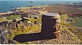 Viewpoint indicator on North Berwick Law, with the Bass Rock in the background


References
- "North Berwick Law". Database of British and Irish Hills. Retrieved 3 October 2018.
- "Law". Dictionary of the Scots Language. Retrieved 28 May 2015.
- Read, W. A. et al. (2002) Carboniferous, page 294 in Trewin, N. H. (2002) The Geology of Scotland, 4th edition, London, The Geological Society.
- "'Whale' jawbones put back on hill". 26 June 2008. Retrieved 30 August 2018.
- Scotsman.com
- Bardwell, Sandra; Megarry, Jacquetta (2018). John Muir Way: A Scottish coast-to-coast route. Rucksack Readers. p. 76. Retrieved 6 October 2018.
- Sawyers, June Skinner (1999). Maverick Guide to Scotland. Pelican Publishing. Retrieved 6 October 2018.
External links
- Computer-generated virtual panoramas North Berwick Law
- Stuart McHardy, The Goddess in the Landscape of Scotland
| Authority control |
|
|---|
На других языках
[de] North Berwick Law
Der North Berwick Law liegt am südlichen Rand der kleinen schottischen Hafenstadt North Berwick in der Region East Lothian am Südufer des Firth of Forth. Es handelt sich um einen 187 Meter hohen Vulkankegel aus Basalt, Rest eines vor 335 Millionen Jahren aktiven Vulkans, der später durch die Gletscher der Kaltzeit überformt wurde und seine heutige längliche Gestalt erhielt. Law ist das schottische Wort für derartige Vulkankegel, wie man sie zum Beispiel auch in Dundee findet.- [en] North Berwick Law
Другой контент может иметь иную лицензию. Перед использованием материалов сайта WikiSort.org внимательно изучите правила лицензирования конкретных элементов наполнения сайта.
WikiSort.org - проект по пересортировке и дополнению контента Википедии