geo.wikisort.org - Mountains
'Mull Hill (Manx: Cronk Meayll also called Meayll Hill or The Mull) is a small hill in the exclave of Rushen Parish at the southern end of the Isle of Man, just outside the village of Cregneash. It is the site of a chambered cairn called Mull Circle or Meayll Circle. Near the summit of the hill also lie the remains of a World War II Chain Home Low RDF station.
| Mull Hill | |
|---|---|
| Cronk Meayll | |
 Mull Circle on top of Mull Hill, looking north towards Port Erin | |
| Highest point | |
| Elevation | 169 m (554 ft) |
| Prominence | c. 154 m |
| Listing | Marilyn |
| Coordinates | 54°04′27″N 4°46′07″W |
| Geography | |
| Location | Rushen, Isle of Man |
| OS grid | SC189676 |
| Topo map | OS Landranger 95 IOM Outdoor Leisure Map (S) |
 | |
Mull Hill Stone Circle is a unique archaeological monument. It consists of twelve burial chambers placed in a ring, with six entrance passages each leading into a pair of chambers. Sherds of ornate pottery, charred bones, flint tools and white quartz pebbles have been found in the burial chambers. This archaeological monument was built around 3500 BC; it is a site of legends with diverse stories about haunting.
The word Meayll means "bald" in Manx Gaelic.
Meayll Circle
- The Stone Circle and artifacts
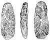 Three views of an adze, from Meayll Hill
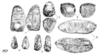 Worked flints found on Meayll Hill
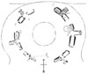 Plan of the Meayll Stone Circle
 Meayll Stone Circle from the east
 Meayll Stone Circle, excavated cist
 Meayll Stone Circle, excavated cist (another view)


References
Bibliography
- Kermode, Philip Moore Callow (June 1894), Allen, J. Romilly (ed.), "The illustrated archaeologist: a quarterly journal, devoted to the study of the antiquities of Great Britain; the development of the arts and industries of man in past ages; and the survivals of ancient usages and appliances in the present", The Illustrated Archaeologist, London: Charles J. Clark (published 1894), I: 1–8
- Kermode, Philip Moore Callow; Herdman, W. A. (1904), Illustrated Notes on Manks Antiquities, Liverpool
Citations
External links
This Manx location article is a stub. You can help Wikipedia by expanding it. |
На других языках
- [en] Mull Hill
[fr] Mull Hill
Le Mull Hill (aussi dénommé Meayll Hill ou The Mull) est une petite colline située à l'extrémité méridionale de l'île de Man, à proximité du village de Cregneash (en), et dont la vue s'étend sur la petite ville côtière de Port Erin, sur la péninsule de Meayll.Другой контент может иметь иную лицензию. Перед использованием материалов сайта WikiSort.org внимательно изучите правила лицензирования конкретных элементов наполнения сайта.
WikiSort.org - проект по пересортировке и дополнению контента Википедии