geo.wikisort.org - Mountains
Mousa Ali (Arabic: موسى علي) is a 2,021 metres (6,631 ft) stratovolcano located on the tri-point of Ethiopia, Eritrea and Djibouti. The volcano is the highest point in Djibouti. The volcano's summit is truncated by a caldera, which contains rhyolitic lava domes and lava flows.[2] The last known eruption occurred before the Holocene era.
| Mousa Ali | |
|---|---|
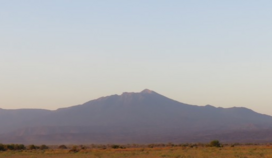 Mousa Ali from Djibouti. | |
| Highest point | |
| Elevation | 2,021 to 2,028 m (6,631 to 6,654 ft)[1][2] |
| Prominence | 1,607 m (5,272 ft)[1][3] |
| Listing | The highest point in Djibouti Ultra |
| Coordinates | 12°28′07″N 42°24′15″E[1] |
| Naming | |
| Native name | موسى علي (Arabic) |
| Geography | |
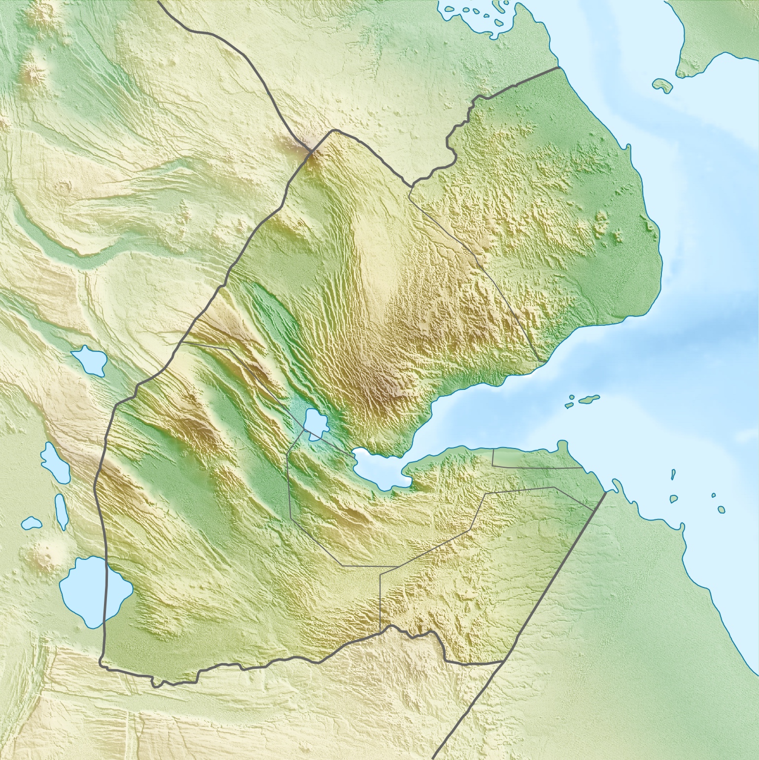 Mousa Ali Location of Mousa Ali in Djibouti (on tri-point border with Eritrea and Ethiopia) | |
| Countries | |
| Regions | Tadjourah Region, Afar Region and Southern Red Sea Region |
| Parent range | Denakil[3] |
| Geology | |
| Mountain type | Stratovolcano |
| Last eruption | Holocene |
| Climbing | |
| First ascent | 1841 |
Mousa Ali is situated at the tri-point of the Tadjourah Region of Djibouti, the Southern Red Sea Region of Eritrea, and the Afar Region of Ethiopia.
Geography

The mountain has two distinct summits, the higher being the south one with an elevation of 2,021 metres The north summit in Ethiopia has an elevation of 1,871 metres. Both summits are separated by a large caldera, about 1 km (0.71 mi) wide and 1514 metres deep. Mousa Ali, in the northern part of the Great Rift Valley region, has Eritrea on its northern flank, Ethiopia on the west, and Djibouti the east and south. The Djiboutian town of Dorra is 36 km to the south-southeast, the Ethiopian volcano Manda-Inakir is 22 km to the southwest, and the road from the Ethiopian town of Manda to the Eritrean port of Assab is 19 km to the northwest.
Wildlife and flora
The mountain is home to an abundant amount of wildlife, lush vegetation, flowering shrubs and trees and various plants.
History
Two sects of Afar live in the area. They are collectively known as Adrúmmi, from 'Adó rum li or "white as Byzantines." The position of Ali Mousa as the tripoint between Ethiopia, Eritrea and Djibouti is not the result of an agreement between the three countries. In December 1948 the British administering Eritrea refused to attend a meeting with the other two parties to determine the exact location of their tripoint, set in a 1908 treaty as 60 km inland from the Red Sea. British administration of Eritrea ended in 1952, and with increasing Ethiopian administration over the ensuing decade, and incorporation into Ethiopia from 1962 to 1993, the boundary was internal, not international. In 2002, the Eritrea-Ethiopia Boundary Commission established the tri-point at the Mousa Ali summit;[4] Ethiopia had pressed for it to be further east, nearer to Dadda'to, Djibouti.
Climate
The temperature of Mousa Ali usually ranges from 7 °C to 17 °C in December and January, and 16 °C to 26 °C from June to September. The weather on the mountain can be very erratic, sometimes severe.
| Climate data for Mousa Ali | |||||||||||||
|---|---|---|---|---|---|---|---|---|---|---|---|---|---|
| Month | Jan | Feb | Mar | Apr | May | Jun | Jul | Aug | Sep | Oct | Nov | Dec | Year |
| Average high °C (°F) | 17.9 (64.3) |
20.4 (68.8) |
20.4 (68.8) |
22.7 (72.8) |
23.7 (74.6) |
24.7 (76.4) |
26.3 (79.3) |
25.8 (78.4) |
24.1 (75.3) |
23.2 (73.7) |
20.6 (69.0) |
18.3 (64.9) |
22.3 (72.2) |
| Average low °C (°F) | 7.9 (46.3) |
8.4 (47.1) |
9.9 (49.8) |
11.8 (53.2) |
13.7 (56.6) |
15.2 (59.3) |
16.9 (62.5) |
16.6 (61.8) |
15.2 (59.3) |
12.7 (54.8) |
10.4 (50.7) |
8.9 (48.0) |
12.3 (54.1) |
| Average rainfall mm (inches) | 5 (0.2) |
6 (0.2) |
11 (0.4) |
34 (1.3) |
39 (1.5) |
6 (0.2) |
6 (0.2) |
53 (2.1) |
47 (1.9) |
13 (0.5) |
9 (0.4) |
13 (0.5) |
242 (9.4) |
| Source: Climate Data | |||||||||||||
Gallery
 On the summit of Moussa Ali looking at the Caldera.
 View of Mousa Ali from the southwest side.


See also
- List of volcanoes in Eritrea
- List of stratovolcanoes
- List of Ultras of Africa
References
- Africa Ultra-Prominences, Peaklist.org, listed as "Moussa Ali Terara" Retrieved 29 September 2011
- "Mousa Ali". Global Volcanism Program. Smithsonian Institution. Retrieved 2007-04-04.
- "Moussa Ali" on Peakbagger Retrieved 29 September 2011
- Eritrea-Ethiopia Boundary Commission (2002-04-13). "Reports of International Arbitral Awards-Decision regarding delimitation of the border between Eritrea and Ethiopia" (PDF). United Nations. pp. 167, 179. Retrieved 2017-01-20.
На других языках
[de] Mousa Alli
Der Mousa Alli (auch Mousa Ali; Afar Mūsa’álli oder Musā’álli, von Mūsa’alé-li, „Musa in seinem Berg“) ist ein 2028 m hoher Schichtvulkan im Dreiländereck von Eritrea, Äthiopien und Dschibuti. In Dschibuti ist er die höchste Erhebung des Landes.- [en] Mousa Ali
[es] Mousa Ali
El Mousa Ali es un estratovolcán de 2.021 metros[1] (6.631 pies) situado en el triple punto fronterizo de los países africanos de Etiopía, Eritrea y Yibuti. El volcán es el punto más alto en Yibuti. La cima del volcán se trunca por una caldera, que contiene domos riolíticos de lava y flujos de lava. La última erupción conocida ocurrió en la época del Holoceno.[fr] Mousa Alli
Le Mousa Alli, aussi appelé Moussa Alli, Moussa ’Ali[1], Musa Ali ou encore Mussa-Ali[2], est un volcan situé qui marque le tripoint des frontières entre l'Érythrée, l'Éthiopie et Djibouti[3]. Avec 2 028 mètres d'altitude, il constitue le point culminant de Djibouti[4].[it] Moussa Ali
Il Moussa Ali è uno stratovulcano dell'Africa situato nel punto di triplice frontiera tra Gibuti, Eritrea ed Etiopia. Con la sua altitudine di 2021 metri s.l.m., rappresenta il punto più elevato del territorio del Gibuti.[ru] Муса-Али (вулкан)
Муса-Али (араб. موسى علي) — вулканический комплекс на стыке между Джибути, Эритреей и Эфиопией. Состоит из трахитово-риолитового стратовулкана, который является самой заметной структурой, кальдеры и риолитовых вулканических куполов. Имеет абсолютную высоту 1993, 2021 и 2028 метров, относительную — 1607 метров[1][2][3]. Является высочайшей точкой Джибути. Входит в хребет Данакиль, который является частью Эфиопского нагорья[4].Другой контент может иметь иную лицензию. Перед использованием материалов сайта WikiSort.org внимательно изучите правила лицензирования конкретных элементов наполнения сайта.
WikiSort.org - проект по пересортировке и дополнению контента Википедии