geo.wikisort.org - Mountains
Mount Ōtenjō (大天井ヶ岳, Ōtenjō-ga-dake) is a 1,438.7 m (4,720 ft) mountain of Ōmine Mountain Range, located on the border of Kurotaki and Kawakami, Nara, Japan. This mountain is one of the Kinki 100 mountains. This mountain is on the route of Ōmine Okugakemichi.
| Mount Ōtenjō | |
|---|---|
| 大天井ヶ岳 | |
 Seen from the SE | |
| Highest point | |
| Elevation | 1,438.7 m (4,720 ft) |
| Listing | List of mountains and hills of Japan by height |
| Coordinates | 34°14′4″N 135°54′52″E |
| Naming | |
| Language of name | Japanese |
| Pronunciation | [oːtendʑoːdake] |
| Geography | |
 Mount Ōtenjō Kurotaki and Kawakami, Nara, Japan | |
| Parent range | Ōmine Mountain Range |
Ōtenjō literally means ‘the great ceiling’.
Route
There are three major routes to the top of this mountain. The most popular route is from Dorokawa, Kurotaki via Gobanzeki and it takes three hours and 15 minutes to the top. Another route is also from Dorokawa via Mount Iwaya and it takes three hours. The other route is from north via Mount Shisuniwa from Yoshinoyama Station, but it takes seven and half hours.
Access
- Dorokawa Bus Stop of Nara Kotsu
- Yoshinoyama Station of Yoshino Ohmine ke-buru Ropeway
Gallery
 Mount Ōtenjō from north (5/2009)
 The top of Mount Ōtenjō (5/2009)
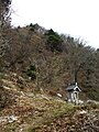
 Religious objects on the top of Mount Ōtenjō (5/2009)
 Mount Shisuniwa from the top of Mount Ōtenjō (5/2009)
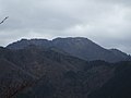 Mount Sanjō from Mount Ōtenjō (5/2009)


References
На других языках
- [en] Mount Ōtenjō
[fr] Mont Ōtenjō
Le mont Ōtenjō (大天井ヶ岳, Ōtenjō-ga-dake?) est une montagne culminant à 1 439 m d'altitude dans les monts Ōmine, à la limite des villages de Kurotaki, Kawakami et Tenkawa dans la préfecture de Nara au Japon.Текст в блоке "Читать" взят с сайта "Википедия" и доступен по лицензии Creative Commons Attribution-ShareAlike; в отдельных случаях могут действовать дополнительные условия.
Другой контент может иметь иную лицензию. Перед использованием материалов сайта WikiSort.org внимательно изучите правила лицензирования конкретных элементов наполнения сайта.
Другой контент может иметь иную лицензию. Перед использованием материалов сайта WikiSort.org внимательно изучите правила лицензирования конкретных элементов наполнения сайта.
2019-2026
WikiSort.org - проект по пересортировке и дополнению контента Википедии
WikiSort.org - проект по пересортировке и дополнению контента Википедии