geo.wikisort.org - Mountains
Mount Tsurumi (鶴見岳, Tsurumi-dake) is a 1,374.5 m (4,510 ft) volcano in Beppu, Ōita, Japan.
| Mount Tsurumi | |
|---|---|
| 鶴見岳 | |
 East side | |
| Highest point | |
| Elevation | 1,374.5 m (4,510 ft) |
| Listing | List of mountains and hills of Japan by height |
| Coordinates | 33°17′12″N 131°25′47″E |
| Naming | |
| Language of name | Japanese |
| Pronunciation | [tsɯɾɯmidake] |
| Geography | |
 Mount Tsurumi Beppu, Ōita, Japan  Mount Tsurumi Mount Tsurumi (Kyushu) | |
| Topo map | Geographical Survey Institute 25000:1 別府東 |
| Geology | |
| Mountain type | Lava dome |
| Last eruption | March to May 867 CE |

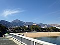
Yufu volcano (left)
Outline
Mount Tsurumi is a lava dome. It has several peaks, including, Mount Kuranoto, Mount Uchi, Mount Garan. This mountain is one of Japan 300 mountains, and a part of Aso Kujū National Park.
Route
The easiest way to reach to the top of Mount Tsurumi is to use Kintetsu Beppu Ropeway. When walking up to the top, it takes about two hours from Toriimae Bus Stop and two and half hours from Higashi Tozanguchi Bus Stop.
Access
- Tsurumi Sanjo Station
- Toriimae Bus Stop
- Higashi Tozanguchi Bus Stop
Gallery
 ESE side
 West side


See also
External links
| Wikimedia Commons has media related to Mount Tsurumi. |
- Tsurumidake and Garandake: National catalogue of the active volcanoes in Japan - Japan Meteorological Agency
- Tsurumi Dake - Geological Survey of Japan
- "Yufu-Tsurumi". Global Volcanism Program. Smithsonian Institution. Retrieved 2021-06-24.
На других языках
- [en] Mount Tsurumi
[fr] Mont Tsurumi
Le mont Tsurumi (鶴見岳, Tsurumidake?) est un volcan culminant à 1 375 m d'altitude sur le territoire de la ville de Beppu dans la préfecture d'Ōita au Japon. Ce dôme de lave compte plusieurs sommets dont le mont Kuranoto, le mont Uchi et le mont Garan.Текст в блоке "Читать" взят с сайта "Википедия" и доступен по лицензии Creative Commons Attribution-ShareAlike; в отдельных случаях могут действовать дополнительные условия.
Другой контент может иметь иную лицензию. Перед использованием материалов сайта WikiSort.org внимательно изучите правила лицензирования конкретных элементов наполнения сайта.
Другой контент может иметь иную лицензию. Перед использованием материалов сайта WikiSort.org внимательно изучите правила лицензирования конкретных элементов наполнения сайта.
2019-2026
WikiSort.org - проект по пересортировке и дополнению контента Википедии
WikiSort.org - проект по пересортировке и дополнению контента Википедии