geo.wikisort.org - Mountains
Mount Tanjō (丹生山, Tanjō-san) is a 514 m (1,686 ft) mountain in the Tanjō Mountains, located in Sakamoto, Yamada, Kita-ku, Kobe, Hyōgo, Japan.
| Mount Tanjō | |
|---|---|
| 丹生山 | |
 Mount Tanjō seen from the south | |
| Highest point | |
| Elevation | 514 m (1,686 ft) |
| Coordinates | 34°46′N 135°6′E |
| Naming | |
| Language of name | Japanese |
| Pronunciation | [tandʑoːsaɴ] |
| Geography | |
 Mount Tanjō Sakamoto, Yamada, Kita-ku, Kobe, Hyōgo, Japan | |
| Parent range | Tanjō Mountains |
Outline and History
Mount Tanjō is not the tallest mountain of Tanjō Mountains, but it is a symbol of the mountain range. In the middle of the mountain, there was a Buddhist temple Myōyō-ji which was said to be established by Donan-Gyoja, a prince of King Seong of Baekje. Today's Tanjō Shrine was is believed to be part of the original temple. Mount Tanjō is also believed to have been old source of mercury, because the name Tanjō, originally means Nyu, mercury. Tanjō Shrine is a place to enshrine a goddess of mercury.
Access
- Tanjō Jinja Mae Bus Stop of Kobe City Bus
- Tsukihara Bus Stop of Kobe City Bus
References
- ‘Kansaishuhen no Yama 250’, Yama to Keikokusha Osakashikyoku
- Official Home Page of the Geographical Survey Institute in Japan
Gallery
 Tanjō Shrine at the top of Mount Tanjo
 Monument of Mount Tanjo Castle
 Ruins of Mount Tanjo Castle
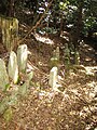 Ruins of Myōyōji Temple
 Ruins of Myōyōji Temple


На других языках
- [en] Mount Tanjō
[fr] Mont Tanjō
Le mont Tanjō (丹生山, Tanjō-san?) est une montagne culminant à 515 m d'altitude dans les monts Tanjō et située dans l'arrondissement Kita-ku de Kobe dans la préfecture de Hyōgo au Japon.Текст в блоке "Читать" взят с сайта "Википедия" и доступен по лицензии Creative Commons Attribution-ShareAlike; в отдельных случаях могут действовать дополнительные условия.
Другой контент может иметь иную лицензию. Перед использованием материалов сайта WikiSort.org внимательно изучите правила лицензирования конкретных элементов наполнения сайта.
Другой контент может иметь иную лицензию. Перед использованием материалов сайта WikiSort.org внимательно изучите правила лицензирования конкретных элементов наполнения сайта.
2019-2026
WikiSort.org - проект по пересортировке и дополнению контента Википедии
WikiSort.org - проект по пересортировке и дополнению контента Википедии