geo.wikisort.org - Mountains
Mount Takami (高見山, Takami-san/Takami-yama) is a 1,248.3 m (4,095 ft) mountain of Daiko Mountains, which is located on the border of Higashiyoshino, Nara, and Matsusaka, Mie, Japan
| Mount Takami | |
|---|---|
| 高見山 | |
 Mount Takami from Hirano(January 2009) | |
| Highest point | |
| Elevation | 1,248.3 m (4,095 ft) |
| Listing | List of mountains and hills of Japan by height |
| Coordinates | 34.429°N 136.088°E |
| Naming | |
| Language of name | Japanese |
| Geography | |
| Location | On the border of Higashiyoshino, Nara, and Matsusaka, Mie, Japan |
| Parent range | Daiko Mountains |
Outline
This mountain is located on the north end of Daiko Mountains. This mountain is considered one of the 300 Famous Japanese Mountains. This mountain is an important part of Muro-Akame-Aoyama Quasi National Park.
Routes
This mountain is very famous for the beautiful frost patterns that form on trees in winter and so attract many climbers. There are several routes to reach the top; one is from Takami-Otoge Pass and it takes about one hour; another route is from Takami-tozanguchi Bus Stop on the Nara Kotsu bus route, and it takes two and a half hours. The third route is from Shimo-Hirano Bus stop, also on the Nara Kotsu bus route, and it also takes two and a half hours.
Gallery
 Takasumi Shrine at the top of Mount Takami (January 2009)
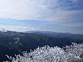 Omine Mountains from Mount Takami (January 2009)
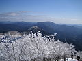 Eastside view of Mount Takami (January 2009)
 Daiko Mountains from Mount Takami (January 2009)
 Katsuragi Mountains from Mount Takami (January 2009)
 Frosts on trees at the top of Mount Takami (1) (January 2009)
 Frosts on trees at the top of Mount Takami (2) (January 2009)
 Takamisugi Cedar


References
На других языках
- [en] Mount Takami
[fr] Mont Takami
Le mont Takami (高見山, Takami-san/Takami-yama?) est une montagne culminant à 1 248 m d'altitude dans les monts Daiko, à la limite de Higashiyoshino dans la préfecture de Nara et Matsusaka dans la préfecture de Mie au Japon.Другой контент может иметь иную лицензию. Перед использованием материалов сайта WikiSort.org внимательно изучите правила лицензирования конкретных элементов наполнения сайта.
WikiSort.org - проект по пересортировке и дополнению контента Википедии