geo.wikisort.org - Mountains
Mount Spry[2] is a small 5,720-ft elevation mountain summit made of Navajo Sandstone located in Zion National Park, in Washington County of southwest Utah, United States. Officially named in 1934, it honors William Spry (1864-1929), the third governor of Utah. The nearest higher peak is The East Temple, 0.34 miles (0.55 km) to the east.[1] Precipitation runoff from the mountain drains into tributaries of the North Fork Virgin River.
| Mount Spry | |
|---|---|
 Mount Spry's southeast aspect (The Sentinel behind left} | |
| Highest point | |
| Elevation | 5,720 ft (1,740 m)[1] |
| Prominence | 440 ft (130 m)[1] |
| Coordinates | 37°13′16″N 112°57′50″W[1] |
| Naming | |
| Etymology | William Spry |
| Geography | |
 Mount Spry Location in Utah  Mount Spry Mount Spry (the United States) | |
| Location | Zion National Park Washington County, Utah United States |
| Parent range | Colorado Plateau |
| Topo map | USGS Springdale East |
| Geology | |
| Age of rock | Jurassic |
| Type of rock | Navajo sandstone |
| Climbing | |
| Easiest route | Scrambling class 4 |
Climbing Routes
Climbing Routes on Mount Spry[3]
- Holy Roller - class 5.10d - 5 pitches
- Swamp Donkey - class 5.12a - 5 pitches
- Shark Tooth Freighter - class 5.10 - 3 pitches
Climate
Spring and fall are the most favorable seasons to visit Mount Spry. According to the Köppen climate classification system, it is located in a Cold semi-arid climate zone, which is defined by the coldest month having an average mean temperature below 32 °F (0 °C), and at least 50% of the total annual precipitation being received during the spring and summer. This desert climate receives less than 10 inches (250 millimeters) of annual rainfall, and snowfall is generally light during the winter.[4]
See also
- Geology of the Zion and Kolob canyons area
- Colorado Plateau
Gallery
 South aspect
 South aspect
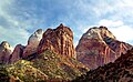 Left to right: Mountain of the Sun, Twin Brothers, Mt. Spry (center), The East Temple
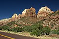 Left to right: Mountain of the Sun, Twin Brothers, Mt. Spry (center), The East Temple
 Mt. Spry with The Sentinel (left)
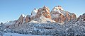


References
- "Mount Spry, Utah". Peakbagger.com.
- U.S. Geological Survey Geographic Names Information System: Mount Spry
- Mount Spry Mountain Project
- "Zion National Park, Utah, USA - Monthly weather forecast and Climate data". Weather Atlas. Archived from the original on August 31, 2020. Retrieved 31 August 2020.
External links
- Zion National Park National Park Service
- Weather forecast: Mount Spry
Другой контент может иметь иную лицензию. Перед использованием материалов сайта WikiSort.org внимательно изучите правила лицензирования конкретных элементов наполнения сайта.
WikiSort.org - проект по пересортировке и дополнению контента Википедии