geo.wikisort.org - Mountains
Mount Silliman is a mountain in California along the boundary between Sequoia National Park and Kings Canyon National Park The summit, at 11,193 feet (3,412 m) is on the Sillman Crest, a part of the Kings-Kaweah Divide.
| Mount Silliman | |
|---|---|
 Mount Silliman, from the north near Silliman Pass | |
| Highest point | |
| Elevation | 11,193 ft (3,412 m) NAVD 88[1] |
| Prominence | 828 ft (252 m)[1] |
| Parent peak | Midway Mountain |
| Coordinates | 36°38′36″N 118°41′47″W[2] |
| Geography | |
 Mount Silliman  Mount Silliman | |
| Location | Tulare County, California, U.S. |
| Parent range | Sierra Nevada |
| Topo map | USGS Mount Silliman |
| Climbing | |
| First ascent | June 28, 1864 by Clarence King, James Gardiner, Richard Cotter, and William Brewer[3] |
| Easiest route | Scramble from Sillman Pass, class 2[4] |
History
The peak was named by members of the Whitney Survey in honor of Benjamin Silliman, professor of chemistry at Yale College. William Brewer, the head of the survey, had studied agricultural chemistry under Silliman. Besides the mountain and crest, there are a pass, a creek, a meadow and a lake that bear the name Silliman.[3]
The first recorded ascent was by Clarence King, James Gardiner, Richard Cotter, and William Brewer on June 28, 1864.[3]
Climb
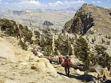 A stand of Foxtail Pines below the summit
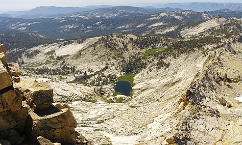 View of Little Lakes from the summit


The summit can be approached by way of the Twin Lakes trail from the Lodgepole Campground on the Generals Highway. From Sillman Pass traverse (class 2) to the east ridge and follow it to the summit. There are several more technical routes to the summit which are mostly class 5.6 or more difficult.[4][5]
Flora
The rare foxtail pine grows directly below Silliman's summit.
See also
- Silliman Pass, directly below
- Twin Peaks, quite near
References
- "Mount Silliman, California". Peakbagger.com. Retrieved 2016-03-26.
- "Mount Silliman". Geographic Names Information System. United States Geological Survey. Retrieved 2016-03-26.
- Browning, Peter (1986). Place Names of the Sierra Nevada. Berkeley: Wilderness Press. p. 199. ISBN 0899971199.
- Secor, R.J. (2009). The High Sierra Peaks, Passes, and Trails (3rd ed.). Seattle: The Mountaineers. ISBN 978-0898869712.
- "Mount Silliman". SummitPost.org.
This Tulare County, California-related article is a stub. You can help Wikipedia by expanding it. |
Другой контент может иметь иную лицензию. Перед использованием материалов сайта WikiSort.org внимательно изучите правила лицензирования конкретных элементов наполнения сайта.
WikiSort.org - проект по пересортировке и дополнению контента Википедии