geo.wikisort.org - Mountains
Mount Pulitzer, also known as Snagtooth, is a 6,283-foot (1,915-metre) mountain summit located within Olympic National Park in Jefferson County of Washington state.[1][4] Mount Pulitzer is the sixth-highest peak in the Bailey Range, which is a subrange of the Olympic Mountains.[1] Its nearest neighbor is Mount Ferry, 0.58 mi (0.93 km) to the northeast, and its nearest higher neighbor is Stephen Peak, 2.58 mi (4.15 km) to the north.[1] Mount Olympus is set 6.8 mi (10.9 km) to the southwest. In clear weather, the mountain can be seen from the visitor center at Hurricane Ridge. Precipitation runoff from the mountain drains into tributaries of the Elwha and Hoh Rivers. The first ascent of the summit was made in 1961 by Doug Waali, Bob Wood, and Kent Heathershaw via the east ridge.[5]
| Mount Pulitzer | |
|---|---|
 Mount Pulitzer, northeast aspect | |
| Highest point | |
| Elevation | 6,283 ft (1,915 m)[1] |
| Prominence | 923 ft (281 m)[1] |
| Parent peak | Stephen Peak (6,418 ft)[2][1] |
| Isolation | 2.58 mi (4.15 km)[2] |
| Coordinates | 47°50′08″N 123°34′27″W[1] |
| Geography | |
 Mount Pulitzer Location of Mount Pulitzer in Washington  Mount Pulitzer Mount Pulitzer (the United States) | |
| Location | Olympic National Park Jefferson County, Washington, US |
| Parent range | Olympic Mountains |
| Topo map | USGS Mount Queets |
| Geology | |
| Age of rock | Eocene |
| Climbing | |
| First ascent | 1961 |
| Easiest route | class 3 scrambling[2] East ridge[3] |
Etymology
This peak was named by the 1889-90 Seattle Press Expedition after Joseph Pulitzer (1847–1911), newspaper publisher of the New York World,[4] his name is now best known for the Pulitzer Prize. The mountain was originally called Mt. Ferry before it was renamed.
Climate
Based on the Köppen climate classification, Mount Pulitzer is located in the marine west coast climate zone of western North America.[6] This climate supports a small un-named glacier on the north slope.[3] Most weather fronts originate in the Pacific Ocean, and travel northeast toward the Olympic Mountains. As fronts approach, they are forced upward by the peaks of the Olympic Range, causing them to drop their moisture in the form of rain or snowfall (Orographic lift). As a result, the Olympics experience high precipitation, especially during the winter months. During winter months, weather is usually cloudy, but, due to high pressure systems over the Pacific Ocean that intensify during summer months, there is often little or no cloud cover during the summer. The months July through September offer the most favorable weather for viewing and climbing.
Geology
The Olympic Mountains are composed of obducted clastic wedge material and oceanic crust, primarily Eocene sandstone, turbidite, and basaltic oceanic crust.[7] The mountains were sculpted during the Pleistocene era by erosion and glaciers advancing and retreating multiple times.
Gallery
 Mt. Pulitzer, north aspect
 Mt. Ferry (left) and Mt. Pulitzer (right of center)
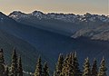 The Bailey Range seen from High Divide featuring Mt. Ferry and Mt. Pulitzer to left, and Mt. Childs on the right.
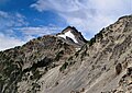 Mount Pulitzer from northeast
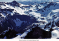 Mt. Pulitzer in upper left


See also
- Olympic Mountains
- Geology of the Pacific Northwest
References
- "Mount Pulitzer". Peakbagger.com.
- ""Mount Pulitzer" - 6,283' WA". listsofjohn.com. Retrieved 2020-06-15.
- climbersguideolympics.com Mount Pulitzer (Snagtooth)
- Parratt, Smitty (1984). Gods and Goblins: A Field Guide to Place Names of Olympic National Park (1st ed.).
- Roy Etten, North America, United States, Washington, Olympic Mountains, New Climbs in the Bailey Range, (1962), American Alpine Journal
- Peel, M. C.; Finlayson, B. L.; McMahon, T. A. (2007). "Updated world map of the Köppen−Geiger climate classification". Hydrol. Earth Syst. Sci. 11: 1633–1644. ISSN 1027-5606.
- Alt, D.D.; Hyndman, D.W. (1984). Roadside Geology of Washington. pp. 249–259. ISBN 0-87842-160-2.
External links
- "Olympic National Park". National Park Service.
- Mount Pulitzer weather: Mountain Forecast
Другой контент может иметь иную лицензию. Перед использованием материалов сайта WikiSort.org внимательно изучите правила лицензирования конкретных элементов наполнения сайта.
WikiSort.org - проект по пересортировке и дополнению контента Википедии