geo.wikisort.org - Mountains
Mount Myōken (妙見山, Myōken-san) is a 1,135.5 m (3,725 ft) mountain on the border of Yabu and Kami, Mikata, Hyogo, Japan. This mountain is one of Hyōgo 50, and a part of Hyonosen-Ushiroyama-Nagisan Quasi-National Park. The other name of this mountain is Mount Ishihara.
| Mount Myōken | |
|---|---|
| 妙見山 | |
 Mount Myōken from the east | |
| Highest point | |
| Elevation | 1,135.5 m (3,725 ft) |
| Listing | List of mountains and hills of Japan by height |
| Coordinates | 35°24′39″N 134°38′41″E |
| Naming | |
| Language of name | Japanese |
| Pronunciation | [mjoːkensaɴ] |
| Geography | |
 Mount Myōken On the border of Yabu, Hyogo and Kami, Mikata, Hyogo, Japan | |
| Parent range | Chūgoku Mountains |
Outline
Mount Myōken is a mountain on the eastern edge of the Chūgoku Mountains. Nikkōin temple is located at the base of the mountain. Originally, the temple was halfway up the mountain, but the Haibutsu-Kishaku Order issued during the Meiji-era forced the move.
Route
This mountain has major two routes to the top. One is from Ishihara Bus Stop of Tantō Bus. The other is from Mount Sobu. From Ishihara Bus Stop, it takes about three hours to the top.
Access
- Ishihara Bus Stop of Tantō Bus
Gallery
 Mount Myōken from WNW
 The top of Mount Myōken
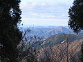 Looking NNW from the top of Mount Myōken
 Looking NE from the top of Mount Myōken
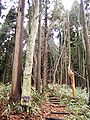 Forest of Mount Myōken
 At the Nikkōin temple at the foot of Mount Myōken


References
- Official Home Page of the Geographical Survey Institute in Japan
- ‘Kansaishuhen no Yama 250’, Yama to Keikokusha Osakashikyoku
На других языках
- [en] Mount Myōken (Tajima)
[fr] Mont Myōken
Le mont Myōken (妙見山, Myōken-san?) – aussi appelé mont Ishihara – est une montagne de 1 139 m d'altitude située à la limite des municipalités de Yabu et Kami dans le district de Mikata de la préfecture de Hyōgo au Japon. Comptant parmi les « 50 monts du Hyōgo », cette montagne fait partie du parc quasi national de Hyonosen-Ushiroyama-Nagisan.Текст в блоке "Читать" взят с сайта "Википедия" и доступен по лицензии Creative Commons Attribution-ShareAlike; в отдельных случаях могут действовать дополнительные условия.
Другой контент может иметь иную лицензию. Перед использованием материалов сайта WikiSort.org внимательно изучите правила лицензирования конкретных элементов наполнения сайта.
Другой контент может иметь иную лицензию. Перед использованием материалов сайта WikiSort.org внимательно изучите правила лицензирования конкретных элементов наполнения сайта.
2019-2026
WikiSort.org - проект по пересортировке и дополнению контента Википедии
WikiSort.org - проект по пересортировке и дополнению контента Википедии