geo.wikisort.org - Mountains
Mount Myōjin (明神岳, Myōjin-dake) is a 1,432 m (4,698 ft) mountain, on the border of Matsusaka, Mie and Kawakami, Nara, Japan. This mountain is one of Daikō Mountains.
| Mount Myōjin | |
|---|---|
| 明神岳 | |
 Mount Myōjin from east | |
| Highest point | |
| Elevation | 1,432 m (4,698 ft) |
| Listing | List of mountains and hills of Japan by height |
| Coordinates | 34°21′39″N 136°5′42″E |
| Naming | |
| Language of name | Japanese |
| Pronunciation | [mjoːdʑindake] |
| Geography | |
| Location | Matsusaka, Mie and Kawakami, Nara, Japan |
| Parent range | Daikō Mountains |
Routes
There are two major routes to the top of Mount Myōjin. The route from Maakodani Tozanguchi takes about three hours. The other route is via Myōjindaira from Ōmata Bus Stop of Nara Kōtsu. It takes about three and half hours.
Access
- Ōmata Bus Stop of Nara Kōtsu
Gallery
 Mount Myōjin from Mount Hinokizuka Okumine (03/2009)
 Mount Myōjin from Mount Azami (03/2009)
 The top of Mount Myōjin (03/2009)
 Myojindaira on the way to Mount Myōjin (03/2009)
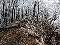 On the way to Mount Myōjin (03/2009)
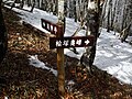 A view at Mount Myōjin (03/2009)
 The entrance of a climbing route to Mount Myōjin (03/2009)
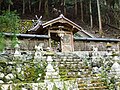 Sasano Shrine at Ōmata (03/2009)


References
- Ōdaigahara, Takami, Kurosoyama, Shobunsha, 2008
- Official Home Page of the Geographical Survey Institute in Japan
На других языках
- [en] Mount Myōjin
[fr] Mont Myōjin
Le mont Myōjin (明神岳, Myōjin-dake?) est une montagne de 1 432 m d'altitude située à la limite des villes de Matsusaka dans la préfecture de Mie et de Kawakami dans la préfecture de Nara au Japon. Elle fait partie des monts Daikō.[ru] Мёдзин (гора)
Мёдзин (яп. 明神岳 Myōjin-dake) — гора в Японии на границе Мацусака и Каваками. Высота горы составляет 1432 метра.Текст в блоке "Читать" взят с сайта "Википедия" и доступен по лицензии Creative Commons Attribution-ShareAlike; в отдельных случаях могут действовать дополнительные условия.
Другой контент может иметь иную лицензию. Перед использованием материалов сайта WikiSort.org внимательно изучите правила лицензирования конкретных элементов наполнения сайта.
Другой контент может иметь иную лицензию. Перед использованием материалов сайта WikiSort.org внимательно изучите правила лицензирования конкретных элементов наполнения сайта.
2019-2026
WikiSort.org - проект по пересортировке и дополнению контента Википедии
WikiSort.org - проект по пересортировке и дополнению контента Википедии