geo.wikisort.org - Mountains
Mount Morrison is an 11,367-foot elevation (3,465 m) mountain summit located in Custer County, Idaho, United States.
| Mount Morrison | |
|---|---|
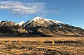
 Northeast aspect | |
| Highest point | |
| Elevation | 11,367 ft (3,465 m)[1] |
| Prominence | 627 ft (191 m)[1] |
| Parent peak | Mount Idaho (12,065 ft)[2] |
| Isolation | 1.20 mi (1.93 km)[2] |
| Coordinates | 44°06′04″N 113°48′03″W[3] |
| Naming | |
| Etymology | Lee Morrison |
| Geography | |
 Mount Morrison Location in Idaho  Mount Morrison Mount Morrison (the United States) | |
| Location | Salmon–Challis National Forest |
| Country | United States of America |
| State | Idaho |
| County | Custer |
| Parent range | Lost River Range Rocky Mountains |
| Topo map | USGS Elkhorn Creek |
| Geology | |
| Age of rock | Mississippian[4] |
| Mountain type | Fault block |
| Type of rock | Limestone[4] |
| Climbing | |
| Easiest route | class 3 scrambling[2] |
Description
Mount Morrison ranks as the 56th-highest peak in Idaho and is part of the Lost River Range which is a subset of the Rocky Mountains.[1] The mountain is set on land managed by Salmon–Challis National Forest. Neighbors include White Cap Peak 2.6 miles southeast, line parent Mount Idaho,[2] 1.2 mile east-northeast, and Borah Peak, the highest peak in Idaho, is 2.7 miles to the north-northeast. Precipitation runoff from the mountain's slopes drains to Big Lost River. Topographic relief is significant as the summit rises 5,000 feet (1,524 meters) above Thousand Springs Valley in 2.5 miles. This landform's unofficial toponym honors Lee Morrison, USGS topographer who mapped much of Idaho from 1924 through 1935.[1] His calculations in 1929 discovered that an unnamed peak (which would become Borah Peak) was the highest in the state.[5]
Climate
Based on the Köppen climate classification, Mount Morrison is located in an alpine subarctic climate zone with long, cold, snowy winters, and cool to warm summers.[6] Winter temperatures can drop below −10 °F with wind chill factors below −30 °F.
See also
- List of mountain peaks of Idaho
 Mountains portal
Gallery
 West aspect
 Lost River Range. Borah Peak centered, Mount Morrison furthest to right, with Mount Idaho between those two.

References
- Idaho: A Climbing Guide, Mount Morrison
- "Mount Morrison - 11,367' ID". listsofjohn.com. Retrieved 2022-09-02.
- "Peak 11367, Idaho". Peakbagger.com. Retrieved 2022-09-02.
- Jeffrey Lee, James P. Evans (2011), Geologic Field Trips to the Basin and Range, Rocky Mountains, Snake River Plain, and Terranes of the U.S. Cordillera, Geological Society of America, p. 118
- Mount Morrison, Climbingidaho.com
- Peel, M. C.; Finlayson, B. L.; McMahon, T. A. (2007). "Updated world map of the Köppen−Geiger climate classification". Hydrol. Earth Syst. Sci. 11: 1633–1644. ISSN 1027-5606.
External links
- Mount Morrison: Idaho: A Climbing Guide
- Lee Morrison: Idaho: A Climbing Guide
- Mount Morrison: Climbingidaho.com
Другой контент может иметь иную лицензию. Перед использованием материалов сайта WikiSort.org внимательно изучите правила лицензирования конкретных элементов наполнения сайта.
WikiSort.org - проект по пересортировке и дополнению контента Википедии