geo.wikisort.org - Mountains
Mount Miyama (深山, Miyama) is a 790.5 m (2,594 ft) mountain, located on the border of Nose, Osaka and Nantan, Kyoto, Japan.
| Mount Miyama | |
|---|---|
| 深山 | |
 Seen from the south | |
| Highest point | |
| Elevation | 790.5 m (2,594 ft) |
| Listing | List of mountains and hills of Japan by height |
| Coordinates | 35°2′30″N 135°22′40″E |
| Naming | |
| Language of name | Japanese |
| Pronunciation | [mijama] |
| Geography | |
| Location | Nose, Osaka and Nantan, Kyoto, Japan |
| Parent range | Hokusetsu Mountains |
| Geology | |
| Mountain type | fault-block |
Outline
Mount Miyama is the tallest mountain of Hokusetsu Mountains. This mountain is one of Osaka 50 mountains, and a part of Hokusetsu Natural Park.
Route
There are three major routes to the top of this mountain. One is from Okururi Valley and it takes one hour and 50 minutes to the top of the mountain. Second one is from Hirono, and it takes two hours 50 minutes. The last one is from Fukuzumi, in Sasayama, Hyōgo and it takes two and half hours.
Access
- Okururikei Bus Stop of Chukyo Bus
- Hirono Bus Stop of Chukyo Bus
- Fukuzumi Bus Stop of Shinki Bus
Gallery
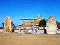 Miyama Shrine on the top of Mount Miyama
 A weather station on the top of Mount Miyama
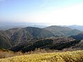 Looking east from the top of Mount Miyama
 Looking WNW from the top of Mount Miyama
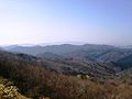 Looking south from the top of Mount Miyama
 Kurasawa Pass
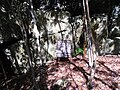 A religious object in Mount Miyama


References
- Hokusetsu, Kyoto Nishiyama, Shobunsha, 2007
- Official Home Page of the Geographical Survey Institute in Japan
На других языках
- [en] Mount Miyama
[fr] Mont Miyama
Le mont Miyama (深山, Miyama?) est une montagne culminant à 791 m d'altitude à la limite entre les villes de Nose dans la préfecture d'Osaka et de Nantan dans la préfecture de Kyoto au Japon.Текст в блоке "Читать" взят с сайта "Википедия" и доступен по лицензии Creative Commons Attribution-ShareAlike; в отдельных случаях могут действовать дополнительные условия.
Другой контент может иметь иную лицензию. Перед использованием материалов сайта WikiSort.org внимательно изучите правила лицензирования конкретных элементов наполнения сайта.
Другой контент может иметь иную лицензию. Перед использованием материалов сайта WikiSort.org внимательно изучите правила лицензирования конкретных элементов наполнения сайта.
2019-2026
WikiSort.org - проект по пересортировке и дополнению контента Википедии
WikiSort.org - проект по пересортировке и дополнению контента Википедии