geo.wikisort.org - Mountains
Mount Mimuro (三室山, Mimuro-yama) is a mountain on the border of Shisō, Hyōgo Prefecture, and Wakasa, Tottori Prefecture, Japan. The height is 1,358.0 m (4,455 ft), and this mountains is the second highest mountain in Hyōgo Prefecture after Mount Hyōno.
| Mount Mimuro | |
|---|---|
| 三室山 | |
 A View of Mount Mimuro from south | |
| Highest point | |
| Elevation | 1,358.0 m (4,455.4 ft) |
| Coordinates | 35°14′N 134°27′E |
| Naming | |
| Language of name | Japanese |
| Pronunciation | [mimɯɾojama] |
| Geography | |
| Location | On the border of Shisō, Hyōgo and Wakasa, Yazu Tottori in Japan |
| Parent range | Chūgoku Mountains |
| Geology | |
| Mountain type | Fault-block |
Outline
Mount Mimuro is one of the fault-block of mountains typical in Chūgoku Mountains. This mountain belongs to the Hyōnosen-Ushiroyama-Nagisan Quasi-National Park. This mountain is one of Hyōgo 50 mountains, and also one of Kinki 100 mountains, Chūgoku 100 mountains.
Access
- Kawachi Bus Stop of Shinki Bus
Gallery
 At the top of Mount Mimuro (10/2008)
 Mount Hyō from Mount Mimuro (10/2008)
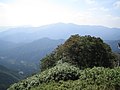 Mount Ushiro from Mount Mimuro (10/2008)
 Mount Takero from Mount Mimuro (10/2008)


References
- Ministry of Environment of Japan
- Official Home Page of the Geographical Survey Institute in Japan
- ‘Shinban Furusato Hyōgo 50 San’, Hyōgo-ken Sangaku Renmei
На других языках
- [en] Mount Mimuro
[fr] Mont Mimuro
Le mont Mimuro (三室山, Mimuro-yama?) est une montagne culminant à 1 358 m d'altitude à la limite des villages de Shisō dans la préfecture de Hyōgo et Wakasa dans la préfecture de Tottori au Japon. C'est la deuxième montagne la plus élevée de la préfecture de Hyōgo après le mont Hyōno.Текст в блоке "Читать" взят с сайта "Википедия" и доступен по лицензии Creative Commons Attribution-ShareAlike; в отдельных случаях могут действовать дополнительные условия.
Другой контент может иметь иную лицензию. Перед использованием материалов сайта WikiSort.org внимательно изучите правила лицензирования конкретных элементов наполнения сайта.
Другой контент может иметь иную лицензию. Перед использованием материалов сайта WikiSort.org внимательно изучите правила лицензирования конкретных элементов наполнения сайта.
2019-2026
WikiSort.org - проект по пересортировке и дополнению контента Википедии
WikiSort.org - проект по пересортировке и дополнению контента Википедии