geo.wikisort.org - Mountains
Mt Matavanu is an active volcano on the island of Savai'i in Samoa. The volcano was formed during an eruption in 1905.[2] Lava flows from the eruption covered a large area of land in the Gaga'emauga district, leading to the relocation of several villages.
| Matavanu | |
|---|---|
 Matavanu erupting, 1906 | |
| Highest point | |
| Elevation | 575 m (1,886 ft)[1] |
| Coordinates | 13°32′S 172°24′W |
| Naming | |
| Language of name | Samoan |
| Geography | |
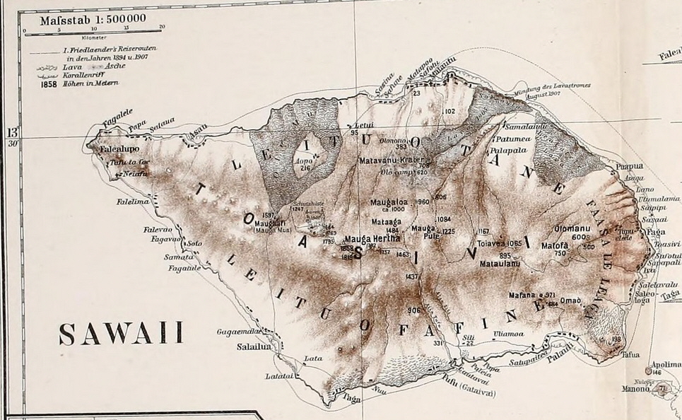
 Matavanu Location in Samoa | |
| Location | Savai'i Island in Samoa |
| Geology | |
| Last eruption | 1905 - 1911 |
The name of the mountain refers to a valley (vanu) with an eye-shaped feature (mata).[3]
1905 - 1911 eruption
The eruption began on 4 August 1905, with a new crater being formed nine miles to the east of Mata o le Afi, which had erupted in 1902.[4] An expedition led by governor Wilhelm Solf observed flames shooting 400 feet into the sky at intervals of ten seconds along with lava flowing through the bush.[4] An expedition to examine the crater found "a larger heap of stones about 300ft high, from the top of which, at intervals of about 10 seconds, masses of stone were being thrown up into the air".[4] A lava-flow 100 feet high had flowed 2.5 miles towards the sea.[4]
The early phase of the eruption was mostly explosive,[2] but in September large amounts of lava had begun to flow from the crater.[5] In mid-September, the cone was estimated at 600 feet high, and lava covered 20 to 25 square miles to a depth of 300 to 400 feet.[6] In December the village of Toapaipai was destroyed by a lava flow,[7] By March 1906 lava had reached the sea, and was flowing parallel to the coast along the top of the reef.[8] The villages of Salago and Sale'aula were destroyed, and the destruction of crops from volcanic fumes was causing famine.[9] In September 1906 geologist H. J. Jensen reported that lave flows had covered 35 square miles, and that what was once a low valley a hundred feet deep had been replaced by a bulging mass of dried lava 1500 feet high.[10] The cone was now 330 feet high, and contained a lava lake.[10] While Jensen reported the volcano was dying down, another explosive eruption began on 5 October 1906, and lava began to flow eastwards.[11] In June 1908 lava was reportedly flowing in a stream 8 miles wide,[12] but by July 1908 it had quietened again.[13] In 1910 it was described as "the most active volcano in the world".[14]
Activity finally began to die down in early 1911, and had ceased by October 1911.[15]
Several villages were relocated to Upolu due to the eruption. the people of Sale'aula were relocated to Salamumu, while those of Mauga and Samalaeʻulu were moved to Le'auva'a.[9][3]
Gallery
|


References
- "Mt Matavanu, Samoa". Peakbagger.com. Retrieved 2014-04-28.
- "Matavanu: a New Volcano in Savaii (German Samoa)" (PDF). Nature. 85: 92-93. 17 November 1910. Retrieved 29 July 2021.
- Fepuleai, Aleni; Weber, Eberhard; Nemeth, Karoly; Muliaina, Tolu (2016). "Eruption Styles of Samoan Volcanoes Represented in Tattooing, Language and Cultural Activities of the Indigenous People". Geoheritage. 9 (3): 395-411. doi:10.1007/s12371-016-0204-1. Retrieved 30 July 2021.
- "VOLCANIC ERUPTION". New Zealand Herald. 29 August 1905. p. 5. Retrieved 29 July 2021 – via Papers Past.
- "THE VOLCANO AT SAVAII". New Zealand Herald. 14 September 1905. p. 6. Retrieved 29 July 2021 – via Papers Past.
- "THE SAVAII ERUPTION". Poverty Bay Herald. 25 September 1905. p. 4. Retrieved 29 July 2021 – via Papers Past.
- "SAVAII IN ERUPTION". Evening Star. 23 January 1906. p. 6. Retrieved 29 July 2021 – via Papers Past.
- "TOPICAL READING". Wairarapa Age. 8 March 1906. p. 4. Retrieved 29 July 2021 – via Papers Past.
- "German Samoa 1900-1914" (PDF). p. 121. Retrieved 29 July 2021.
- "VOLCANIC ACTIVITY IN THE ISLANDS". Christchurch Star. 29 September 1906. p. 2. Retrieved 29 July 2021 – via Papers Past.
- "ISLAND NEWS". Poverty Bay Herald. 24 November 1906. p. 7. Retrieved 29 July 2021 – via Papers Past.
- "Island Ruined by a Volcano". Oamaru Mail. 12 September 1908. p. 2. Retrieved 29 July 2021.
- "SAMOA'S VOLCANO". Dominion. 6 August 1908. p. 8. Retrieved 29 July 2021 – via Papers Past.
- J. E. Newell (1 August 1910). "The Most Active Volcano in the World". The Lone Hand. Vol. 7, no. 40. p. 274-278. Retrieved 30 July 2021 – via National Library of Australia.
- "SAMOA'S VOLCANIC OUTBURSTS CEASE". Oamaru Mail. 6 April 1912. p. 3. Retrieved 29 July 2021 – via Papers Past.
На других языках
[de] Matavanu
Der Matavanu ist ein aktiver Vulkan im Bezirk Gagaʻemauga der Insel Savaiʻi in Samoa. Die bei seinem Ausbruch vom 4. August 1905 bis November 1911 ausgeflossene Lava bedeckt eine Fläche von 50 km².[1]- [en] Mount Matavanu
[fr] Matavanu
Le Matavanu est un volcan actif situé sur l'île de Savai'i, dans les Samoa. Il s'élève à 575 m[1].[ru] Матавану
Матавану (англ. Mt Matavanu) — вулканический конус, входящий в щитовой вулкан на острове Савайи в Самоа.Другой контент может иметь иную лицензию. Перед использованием материалов сайта WikiSort.org внимательно изучите правила лицензирования конкретных элементов наполнения сайта.
WikiSort.org - проект по пересортировке и дополнению контента Википедии