geo.wikisort.org - Mountains
Mount Manypeaks is a distinctive peak located approximately 35 kilometres (22 mi) north-east of Albany, 10 kilometres (6 mi) north-east of Two Peoples Bay and 6 kilometres (4 mi) south-east of the town of Manypeaks, in Western Australia. Mount Manypeaks Nature Reserve lies to the south of the peak, extending along the coast.
| Mount Manypeaks | |
|---|---|
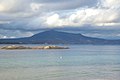
 Mount Manypeaks from South Coast Highway | |
| Highest point | |
| Elevation | 565 m (1,854 ft) |
| Prominence | 565 m (1,854 ft) |
| Coordinates | 34°53′46″S 118°15′43″E |
| Geography | |
 Mount Manypeaks Location in Western Australia | |
| Location | Great Southern of Western Australia |
History
The mountain is the dominant feature in the area and was named by Captain Matthew Flinders in January 1802 whilst surveying the south coast region in HMS Investigator. Flinders noted in his journal: "There are a number of small peaks upon the top of this ridge, which induced me to give it the name Mount Manypeak". The plural form has now become the accepted form of spelling.[1][2]
Location and description
Situated around 35 kilometres (22 mi) north-east of Albany, 10 kilometres (6 mi) north-east of Two Peoples Bay and 6 kilometres (4 mi) south-east of the town of Manypeaks, the mountain lies within the City of Albany local government area.[3]
Geology
The Mount Manypeaks formation has a total length of 22 kilometres (14 mi) and has a width of 3 kilometres (2 mi). The ridge is made up primarily of a type of granite, proterozoic porphyritic biotite granite as well as adamellite. In places limestone lies over the granite block.[citation needed]
Birds
The Mount Manypeaks Nature Reserve forms part of the Two Peoples Bay and Mount Manypeaks Important Bird Area, identified as such by BirdLife International because of its significance in the conservation of several rare and threatened bird species.[4]
Nature reserve
Mount Manypeaks Nature Reserve stretches along the coast to the south of the mountain peak.[5][6]
 Mount Manypeaks from Two Peoples Bay
 Mount Manypeaks from Bettys Beach


References
- Flinders, Matthew (20 May 1814). "4". A voyage to Terra Australis: undertaken for the purpose of completing the discovery of that vast country, and prosecuted in the years 1801, 1802 and 1803. Vol. 1. London: G. & W. Nicol. p. 75. Retrieved 20 April 2019.
- "History of country town names – M". Western Australian Land Information Authority. Retrieved 25 May 2007.
- "Aussie Heritage - Mount Manypeaks Area". 2007. Retrieved 25 May 2007.
- BirdLife International. (2011). Important Bird Areas factsheet: Two Peoples Bay and Mount Manypeaks. Downloaded from http://www.birdlife.org on 2011-11-18.
- "Mount Manypeaks Nature Reserve WA". ExplorOz. Retrieved 3 April 2022.
- "The Coastline to the east Albany townsite". Australia So Much to See. Retrieved 3 April 2022.
На других языках
- [en] Mount Manypeaks
[fr] Mont Manypeaks
Le mont Manypeaks (565 m) est un sommet très visible situé à environ 35 kilomètres au nord-est d'Albany, à 10 kilomètres au nord-est de la baie des Deux Peuples et à 6 km au sud-est de la ville de Manypeaks dans la zone d'administration locale de la cité d'Albany.Другой контент может иметь иную лицензию. Перед использованием материалов сайта WikiSort.org внимательно изучите правила лицензирования конкретных элементов наполнения сайта.
WikiSort.org - проект по пересортировке и дополнению контента Википедии