geo.wikisort.org - Mountains
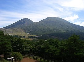
Karakunidake (韓国岳) or Mount Karakuni (1,700m) is a volcano in Kagoshima and Miyazaki Prefectures, Japan. It is part of Kirishima-Yaku National Park.[1][2]
| Mount Karakuni | |
|---|---|
| Karakunidake | |
 Mount Karakuni, September 2008 | |
| Highest point | |
| Elevation | 1,700 m (5,600 ft)[1] |
| Coordinates | 31°56′03″N 130°51′42″E |
| Geography | |
Name
Karakunidake was named as such from two accounts before the Edo period: the first of which referred to the mountain's barren surface, and the second which claimed that climbers can see the distant Korean Peninsula across the sea.[3]
Some maps erroneously spell its name as "唐国岳" (Karakunidake), with the kanji "唐" in place of "韓".
See also
Wikimedia Commons has media related to Mount Karakuni.
- Kirishima-Yaku National Park
References
- "Kirishima-Yaku National Park". Natural Parks Foundation. Archived from the original on 11 June 2011. Retrieved 24 March 2011.
- "Introducing places of interest: Kirishima-Yaku National Park". Ministry of the Environment. Archived from the original on 22 March 2011. Retrieved 24 March 2011.
- Mt. Karakunidake - Japan National Tourism Organization
На других языках
- [en] Mount Karakuni
[fr] Mont Karakuni
Le mont Karakuni (韓国岳, Karakunidake?) est un volcan du Japon situé dans les monts Kirishima dont il est le point culminant avec 1 700 mètres d'altitude.Текст в блоке "Читать" взят с сайта "Википедия" и доступен по лицензии Creative Commons Attribution-ShareAlike; в отдельных случаях могут действовать дополнительные условия.
Другой контент может иметь иную лицензию. Перед использованием материалов сайта WikiSort.org внимательно изучите правила лицензирования конкретных элементов наполнения сайта.
Другой контент может иметь иную лицензию. Перед использованием материалов сайта WikiSort.org внимательно изучите правила лицензирования конкретных элементов наполнения сайта.
2019-2025
WikiSort.org - проект по пересортировке и дополнению контента Википедии
WikiSort.org - проект по пересортировке и дополнению контента Википедии
