geo.wikisort.org - Mountains
Mount Gahinga is a dormant/extinct volcano in the Virunga Mountains on the border between Rwanda and Uganda. Gahinga lies between Muhabura and Sabyinyo, but is the smallest of these three. Mount Gahinga, also known in the local Kinyarwanda/Rufumbira dialect as "a small pile of stones", has a swampy caldera on its peak. The caldera is believed to be about 180 m (591 ft) wide.[2] Mgahinga Gorilla National Park also got its name from this volcano. Mount Gahinga, whose elevation is 3,473 m (11,394 ft), is part of a chain of eight volcanic mountains of the Mufumbiro ranges. The volcano chain spans across Uganda, Rwanda and the Democratic Republic of Congo.
| Mount Gahinga | |
|---|---|
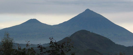 Mts. Gahinga (left) and Muhabura (right) | |
| Highest point | |
| Elevation | 3,474 m (11,398 ft) |
| Prominence | 423 m (1,388 ft) |
| Coordinates | 01°23′13″S 29°38′48″E[Notes 1] |
| Naming | |
| English translation | A little pile of stones |
| Language of name | Kinyarwanda |
| Geography | |
 Mount Gahanga Rwanda–Uganda  Mount Gahanga Mount Gahanga (Uganda) | |
| Parent range | Virunga Mountains |
| Geology | |
| Mountain type | Stratovolcano |
| Last eruption | unknown[1] |
| Climbing | |
| Easiest route | Hike |
The vegetation across the mountain can be described as afro-montane with bamboo composing the main vegetation. Like Muhabura and Sabyinyo, the bamboo forests on Mount Gahinga are a habitat of the endangered mountain gorilla. There are several other species of animals and birds that form part of the Mount Gahinga ecosystem. The golden monkeys are notable to these.
References
- "Mahavura". Global Volcanism Program. Smithsonian Institution. Retrieved 2020-01-06.
-
"Mgahinga Gorilla National Park - Areas of Interest: The Virunga Volcanoes". Uganda Wildlife Authority. Retrieved 2020-01-06.
{{cite web}}: CS1 maint: url-status (link)
- Notes
- See the Synonyms & Subfeatures tab on the GVP page
This Rwanda location article is a stub. You can help Wikipedia by expanding it. |
This Uganda location article is a stub. You can help Wikipedia by expanding it. |
На других языках
[de] Gahinga
Der Gahinga (auch als Mgahinga bezeichnet) ist ein Berg in Uganda und der kleinste der Vulkane in der Virunga-Kette. Der Gipfelbereich ist durch einen großen Krater gekennzeichnet, in dem sich eine afro-alpine Sumpflandschaft gebildet hat. Der Gipfel liegt auf der Grenze zwischen Ruanda und Uganda.- [en] Mount Gahinga
[fr] Gahinga
Le Gahinga, également appelé Mgahinga[1], est un volcan situé sur la frontière entre le Rwanda et l'Ouganda[2],[3].[it] Gahinga
Il monte Gahinga (3474 m) è un vulcano estinto/dormiente situato al confine fra Ruanda e Uganda.Другой контент может иметь иную лицензию. Перед использованием материалов сайта WikiSort.org внимательно изучите правила лицензирования конкретных элементов наполнения сайта.
WikiSort.org - проект по пересортировке и дополнению контента Википедии