geo.wikisort.org - Mountains
Mount Conner, also known as Atila, Artilla, or Fool-uru,[2] is a mountain located in the southwest corner of the Northern Territory of Australia, 75 kilometres (47 mi) southeast of Lake Amadeus, in the locality of Petermann.[1] It lies within the Curtin Springs cattle station in Pitjantjatjara country,[3] close to the site of the Kungkarangkalpa (Seven Sisters) Dreaming.[4] Its height reaches 859 metres (2,818 ft) above sea level and 300 metres (984 ft) above ground level.[5]
| Mount Conner | |
|---|---|
 Mount Conner seen from the road to Uluru / Ayers Rock | |
| Highest point | |
| Elevation | 859 m (2,818 ft) AHD |
| Coordinates | 25°29′34″S 131°53′52″E[1] |
| Naming | |
| Etymology | M. L. Conner |
| Geography | |
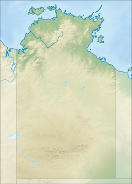 Mount Conner Location in the Northern Territory | |
| Location | Petermann, Northern Territory,[1] Australia |

Geology
The sides of Mount Conner are blanketed by scree (talus) and its top is blanketed by colluvium. The base of Mount Conner is surrounded by alluvium.[6][7][8]
The summit of Mount Conner, along with the summits of low domes in the Kata Tjuta complex and summit levels of Uluru, is an erosional remnant of a Cretaceous geomorphic surface. It is considered to be a classic example of an inselberg created by erosion of surrounding strata.[9]
See also
- List of mountains of the Northern Territory
References
- "Place Names Register Extract for "Mount Conner"". NT Place Names Register. Northern Territory Government. Retrieved 14 June 2019.
- Junker, Ute (4 March 2015). "'Fool-uru': The rock tourists think is Uluru". Stuff. Retrieved 14 April 2022.
- "Central Australia, 1940". SA Memory. State Library of South Australia. 29 October 2009. Retrieved 19 September 2015.
- "Seven Sisters Dreaming". 24 March 2014. Retrieved 19 September 2015.
- "Mount Conner". Encyclopædia Britannica Online. Encyclopædia Britannica. 2011.
- Young, DN, N Duncan, A Camacho, PA Ferenczi, and TLA Madigan (2002a) Ayers Rock, SG 52-8 map, 1:250 000 Geological Series (Second Edition), Northern Territory Geological Survey. scale 1:250 000, Darwin, Northern Territory Geological Survey, Australia.
- Young, DN, N Duncan, A Camacho, PA Ferenczi, and TLA Madigan (2002b) Ayers Rock, SG 52-8 Explanatory Text, 1:250 000 Geological Series (Second Edition). scale 1:250 000, Darwin, Northern Territory Geological Survey, Australia.
- Edgoose, CJ (2012) The Amadeus Basin, central Australia. Episodes. 35(1):257-263.
- Twidale, C.R. (2007) Ancient Australian Landscapes. Rosenberg Publishing, Kenthurst, New South Wales. 144 pp.
Additional sources
- Ayers Rock Geology Map (Map) (1st ed.). 1:250,000. Sheet SG52-8. Northern Territory Geological Survey. 1967.
- Ayers Rock Geology Map (Map) (2nd ed.). 1:250,000. Sheet SG52-8. Northern Territory Geological Survey. 2002.
- Johnson, David (2004). The Geology of Australia. Cambridge University Press. ISBN 0-521-84121-6.
Further reading
- Thompson, R B (1995). A Guide to the Geology and Landforms of Central Australia. Alice Springs: Northern Territory Geological Survey. ISBN 0-7245-2527-0.
На других языках
[de] Mount Conner
Mount Conner ist ein Berg bzw. Tafelberg in Australien, in der Sprache der Anangu trägt er den Namen Atila oder auch Artilla. Er erreicht eine Höhe von 300 m über dem Boden bzw. 859 m über dem Meeresspiegel. Sein Alter wird auf ca. 700 Millionen Jahre geschätzt. Er wurde von William Gosse 1873 nach M. L. Conner, einem südaustralischen Politiker, der viele der ersten Siedler in Australien unterstützte, benannt. Seinen Namen findet man auch oft fälschlicherweise als Mount Connor.- [en] Mount Conner
[fr] Mont Conner
Le mont Conner (aussi connu sous le nom d'Attila et d'Artilla, occasionnellement de Mount Connor), est une montagne culminant à 859 m d'altitude et 300 m au-dessus du niveau du sol au sud-est du lac Amédée, dans le Sud-Ouest du Territoire du Nord, en Australie, à 88 km au sud-est d'Uluru.Другой контент может иметь иную лицензию. Перед использованием материалов сайта WikiSort.org внимательно изучите правила лицензирования конкретных элементов наполнения сайта.
WikiSort.org - проект по пересортировке и дополнению контента Википедии