geo.wikisort.org - Mountains
Mount Cameron is a 7,190-foot-elevation (2,192 meter) triple-summit mountain located within Olympic National Park in Jefferson County of Washington state. Mount Cameron is situated 21 miles southwest of Sequim, and set within the Daniel J. Evans Wilderness. Topographic relief is significant as the southeast aspect rises over 3,300 feet (1,006 meters) above the Dosewallips River in approximately one mile. Precipitation runoff from the mountain drains south into the Dosewallips River, north to the Gray Wolf River via Cameron Creek, and west into headwaters of Lost River. Neighbors include line parent Mount Deception, 4.5 mi (7.2 km) to the east, and proximate parent Mount Johnson, 4.5 mi (7.2 km) to the east.[2]
| Mount Cameron | |
|---|---|
 North aspect of Mt. Cameron | |
| Highest point | |
| Elevation | 7,190 ft (2,192 m)[1] |
| Prominence | 990 ft (302 m)[1] |
| Parent peak | Mount Johnson (7,680 ft)[2] |
| Isolation | 4.52 mi (7.27 km)[2] |
| Coordinates | 47°49′31″N 123°19′42″W[3] |
| Geography | |
 Mount Cameron Location of Mount Cameron in Washington  Mount Cameron Mount Cameron (the United States) | |
| Location | Olympic National Park Jefferson County, Washington, US |
| Parent range | Olympic Mountains |
| Topo map | USGS Wellesley Peak |
| Geology | |
| Age of rock | Eocene |
| Climbing | |
| Easiest route | class 2 scrambling[1] |
Etymology
This landform's name was officially adopted in 1969 by the U.S. Board on Geographic Names.[3] This mountain, Cameron Pass, Cameron Glaciers, Cameron Creek, and Cameron Basin are named after Amos Benson Cameron (1872-1951), an early settler of this area who homesteaded for 41 years in the Deer Park area with his wife and 14 children.[4] He pioneered the first trail into Cameron Basin.
Climate
Based on the Köppen climate classification, Mount Cameron is located in the marine west coast climate zone of western North America.[5] Most weather fronts originate in the Pacific Ocean, and travel east toward the Olympic Mountains. As fronts approach, they are forced upward by the peaks of the Olympic Range, causing them to drop their moisture in the form of rain or snowfall (Orographic lift). As a result, the Olympics experience high precipitation, especially during the winter months. This climate supports the Cameron Glaciers on the north slope. During winter months, weather is usually cloudy, but due to high pressure systems over the Pacific Ocean that intensify during summer months, there is often little or no cloud cover during the summer. The months June through September offer the most favorable weather for viewing or climbing this mountain.[1]
Geology
The Olympic Mountains are composed of obducted clastic wedge material and oceanic crust, primarily Eocene sandstone, turbidite, and basaltic oceanic crust.[6] The mountains were sculpted during the Pleistocene era by erosion and glaciers advancing and retreating multiple times.
Gallery
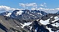 North aspect of Mount Cameron
 North aspect of Mount Cameron centered at top,
as viewed from Elk Mountain


See also
- Olympic Mountains
- Geology of the Pacific Northwest
References
- Mount Cameron, climbersguideolympics.com
- "Cameron, Mount - 7,190' WA". listsofjohn.com. Retrieved 2021-12-25.
- "Mount Cameron". Geographic Names Information System. United States Geological Survey, United States Department of the Interior. Retrieved 2021-12-25.
- Parratt, Smitty (1984). Gods and Goblins: A Field Guide to Place Names of Olympic National Park (1st ed.).
- Peel, M. C.; Finlayson, B. L.; McMahon, T. A. (2007). "Updated world map of the Köppen−Geiger climate classification". Hydrol. Earth Syst. Sci. 11: 1633–1644. ISSN 1027-5606.
- Alt, D.D.; Hyndman, D.W. (1984). Roadside Geology of Washington. pp. 249–259. ISBN 0-87842-160-2.
External links
- "Olympic National Park". National Park Service.
- Weather forecast: Mount Cameron
- Amos B. Cameron: biography
Places adjacent to Mount Cameron (Washington) | ||||||||||||||||
|---|---|---|---|---|---|---|---|---|---|---|---|---|---|---|---|---|
| ||||||||||||||||
Другой контент может иметь иную лицензию. Перед использованием материалов сайта WikiSort.org внимательно изучите правила лицензирования конкретных элементов наполнения сайта.
WikiSort.org - проект по пересортировке и дополнению контента Википедии