geo.wikisort.org - Mountains
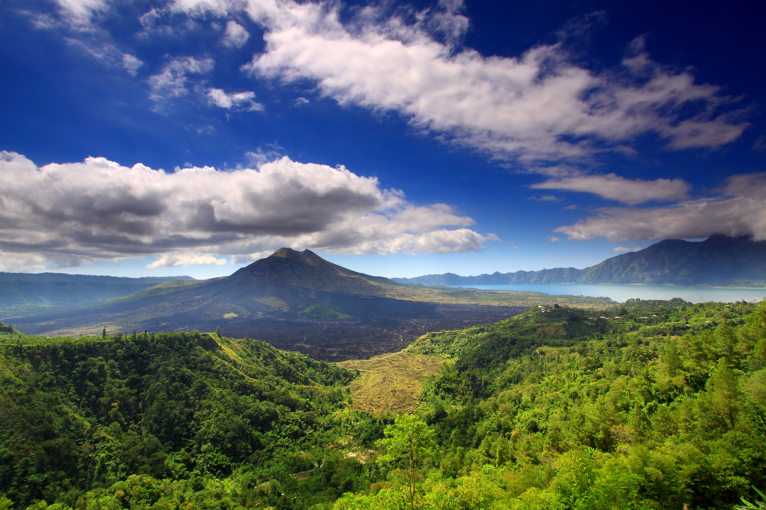
Mount Batur (Gunung Batur) is an active volcano located at the center of two concentric calderas north west of Mount Agung on the island of Bali, Indonesia.[1] The south east side of the larger 10×13 km caldera contains a caldera lake. Both the larger caldera, and a smaller 7.5 km caldera were formed by a collapse of the magma chamber, the first larger collapse taking place about 29,300 years ago, and the second inner caldera collapsing about 20,150 years ago.[2] Another estimate of the inner caldera's formation date, formed during emplacement of the Bali (or Ubud) ignimbrite, has been dated at about 23,670 and 28,500 years ago.[3]
| Mount Batur | |
|---|---|
 Mount Batur and lake  | |
| Highest point | |
| Elevation | 1,717 m (5,633 ft) |
| Listing | Spesial Ribu |
| Coordinates | 8°14′20″S 115°22′39″E |
| Geography | |
 Mount Batur Bali | |
| Location | Bangli Regency, Bali, Indonesia |
| Geology | |
| Mountain type | Volcanic caldera |
| Last eruption | 1999 to 2000 |
The first documented eruption was in 1804 and the most recent was in 2000.[4]
Active volcano and Lake Batur in the caldera
The eruption that brought this volcano to be visible above the ocean is one of the most forceful across the Earth.[citation needed] This volcano is marked by a collapsed top, called a caldera.
The southeast wall of the inner caldera lies beneath Lake Batur; Batur cone has been constructed within the inner caldera to a height above the outer caldera rim. The Batur stratovolcano has produced vents over much of the inner caldera, but a NE-SW fissure system has localized the Batur I, II, and III craters along the summit ridge. Historical eruptions have been characterized by mild-to-moderate explosive activity sometimes accompanied by lava emission. Basaltic lava flows from both summit and flank vents have reached the caldera floor and the shores of Lake Batur over its history.[3]
The caldera contains an active, 700-metre-tall stratovolcano rising above the surface of Lake Batur. The first documented eruption of Batur was in 1804, and it has been frequently active since then, most recently in 2000.[3][4] The substantial lava field from the 1968 eruption is visible today when viewed from Kintamani, a town on the southwest ridge of the caldera.
Villages in the caldera
The caldera is populated and includes the four main villages of Kedisan, Songan, Trunyan and Toya Bungkah, among a total of 15 villages. The locals largely rely on agriculture for income but tourism has become increasingly popular due to the relatively straightforward trek to the summit of the central crater.[5]
Global Geoparks Network
On 20 September 2012 UNESCO made Mount Batur Caldera a part of the Global Geoparks Network.[6][7]
Sedimentation
Heavy sedimentation in Mount Batur Caldera decreases the water in the lake. A plan was devised to restrict locations around the lake for tourist accommodations, to inform residents of the problems of fish farm cages in the lake, and perhaps to dredge some of the natural sedimentation from volcanic ash.[8]
The lake is subject to water pollution from fishing and agricultural run off, promoting the growth of too many water hyacinths, further worsening conditions in the lake, causing some to wonder if the lake will disappear between heavy sedimentation at the bottom and a dense cover of water hyacinths.[9][10]
See also
References
- Geiger, Harri; Troll, Valentin R.; Jolis, Ester M.; Deegan, Frances M.; Harris, Chris; Hilton, David R.; Freda, Carmela (2018-07-12). "Multi-level magma plumbing at Agung and Batur volcanoes increases risk of hazardous eruptions". Scientific Reports. 8 (1): 10547. Bibcode:2018NatSR...810547G. doi:10.1038/s41598-018-28125-2. ISSN 2045-2322. PMC 6043508. PMID 30002471.
- Sutawidjaja, Igan S. (June 2014). "Ignimbrite Analyses of Batur Caldera, Bali, based on 14C Dating". Indonesian Journal on Geoscience. doi:10.17014/ijog.vol4no3.20094.
- "Batur General Information". Global Volcanism Program, National Museum of Natural History. Smithsonian Institution. Retrieved January 16, 2016.
- Desy Nurhayati (11 November 2009). "Mt. Batur alert raised to 'caution'". Jakarta Post. Retrieved January 16, 2016.
- Langston-Able, Nick (2007). Playing with Fire: Adventures in Indonesia. Freakash. pp. 85–98. ISBN 978-0-9553403-4-5.
- "Kaldera Gunung Batur Sebagai Taman Bumi Global" [Caldera of Mount Batur As Global Earth Park]. Pikiran Rakyat. September 30, 2012. Archived from the original on September 22, 2017. Retrieved January 16, 2016.
the geopark is an award from UNESCO for park managers who are able to implement conservation earth geology and also use it as a tourist attraction.
- Nyoman Modern (September 30, 2012). "UNESCO Tetapkan Kaldera Gunung Batur sebagai Jaringan Taman Bumi Global" [UNESCO Set Mount Batur Caldera as Global Earth Garden Network]. Voice of America (Bahasa Indonesia). Retrieved January 16, 2016.
- Luh De Suriyani (November 19, 2008). "Damaged Lake Batur approved as top government priority". Jakarta Post. Retrieved January 16, 2016.
- "Menyelamatkan Danau Batur, Menyelamatkan Kehidupan" [Saving Lake Batur, Saving Lives]. Agro Indonesia. November 24, 2015. Retrieved January 16, 2016.
- "Eceng Gondok Kian Luas" [Increase in Water Hyacinth Size]. Bali: Denpost Theme. November 14, 2014. Archived from the original on November 7, 2017. Retrieved January 16, 2016.
External links
- "Batur". Global Volcanism Program. Smithsonian Institution.
 Kintamani travel guide from Wikivoyage
На других языках
[de] Batur (Vulkan)
Der Batur ist ein aktiver Schichtvulkan im Zentrum zweier konzentrischer Calderen im Kreis Bangli auf der indonesischen Insel Bali.- [en] Mount Batur
[fr] Batur
Le Batur, en indonésien Gunung Batur, est un volcan d'Indonésie situé dans le nord de l'île de Bali.[ru] Гунунг-Батур
Гунунг-Батур (индон. Gunung Batur) — вулкан на острове Бали, входящем в состав одноимённой провинции Индонезии.Другой контент может иметь иную лицензию. Перед использованием материалов сайта WikiSort.org внимательно изучите правила лицензирования конкретных элементов наполнения сайта.
WikiSort.org - проект по пересортировке и дополнению контента Википедии