geo.wikisort.org - Mountains
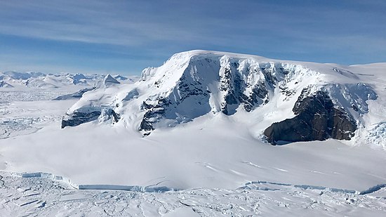
Mount Balfour (69°19′00″S 67°13′00″W) is a bastion-like rocky mountain, 1,010 metres (3,310 ft) high, which lies at the mouth of Fleming Glacier, close to the junction with the Wordie Ice Shelf on the west side of the Antarctic Peninsula. First roughly surveyed in 1936 by the British Graham Land Expedition under Rymill, and resurveyed by the Falklands Islands Dependencies Survey in 1948. It was named for Henry Balfour, President of the Royal Geographical Society from 1936 to 1938.

References
![]() This article incorporates public domain material from the United States Geological Survey document: "Mount Balfour". (content from the Geographic Names Information System)
This article incorporates public domain material from the United States Geological Survey document: "Mount Balfour". (content from the Geographic Names Information System)
На других языках
[de] Mount Balfour
Mount Balfour ist ein 1010 m hoher, bollwerkähnlicher und felsiger Berg an der Fallières-Küste des Grahamlands im Norden der Antarktischen Halbinsel. Er ragt nahe der Mündung des Fleming-Gletschers in den Forster-Piedmont-Gletscher unweit der Nahtstelle zum Wordie-Schelfeis auf.- [en] Mount Balfour (Antarctica)
Текст в блоке "Читать" взят с сайта "Википедия" и доступен по лицензии Creative Commons Attribution-ShareAlike; в отдельных случаях могут действовать дополнительные условия.
Другой контент может иметь иную лицензию. Перед использованием материалов сайта WikiSort.org внимательно изучите правила лицензирования конкретных элементов наполнения сайта.
Другой контент может иметь иную лицензию. Перед использованием материалов сайта WikiSort.org внимательно изучите правила лицензирования конкретных элементов наполнения сайта.
2019-2025
WikiSort.org - проект по пересортировке и дополнению контента Википедии
WikiSort.org - проект по пересортировке и дополнению контента Википедии