geo.wikisort.org - Mountains
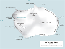
Mosbytoppane[1] (earlier Mosbytoppen, sometimes anglicized as Mosby Peak), are two crags to the southwest of the caldera of the island of Bouvetøya. The tallest is a snow-covered peak 670 meters (2,200 ft) above mean sea level and 1.3 kilometers (0.81 mi) northeast of Norvegiaodden. It was charted by the First Norvegia Expedition in 1927–28, under Captain Harald Horntvedt. It is named for Hakon Mosby, an oceanographer and meteorologist who was one of two scientists on the expedition.[2]
References
- "Mosbytoppane". Norwegian Polar Institute. Archived from the original on 14 January 2014. Retrieved 12 May 2012.
- "Mosby Peak". Geographic Names Information System. Archived from the original on 12 May 2012. Retrieved 12 May 2012.
This Bouvet Island location article is a stub. You can help Wikipedia by expanding it. |
На других языках
[de] Mosbytoppen
Der Mosbytoppen (norwegisch) ist ein 670 m hoher und verschneiter Berg im Westen der Bouvetinsel im Südatlantik. Er ragt 1,1 km nordöstlich der Landspitze Norvegiaodden auf.- [en] Mosbytoppane
Текст в блоке "Читать" взят с сайта "Википедия" и доступен по лицензии Creative Commons Attribution-ShareAlike; в отдельных случаях могут действовать дополнительные условия.
Другой контент может иметь иную лицензию. Перед использованием материалов сайта WikiSort.org внимательно изучите правила лицензирования конкретных элементов наполнения сайта.
Другой контент может иметь иную лицензию. Перед использованием материалов сайта WikiSort.org внимательно изучите правила лицензирования конкретных элементов наполнения сайта.
2019-2026
WikiSort.org - проект по пересортировке и дополнению контента Википедии
WikiSort.org - проект по пересортировке и дополнению контента Википедии