geo.wikisort.org - Mountains
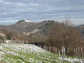
Monte Rua is a mountain in the Euganean Hills of Padua Province, Italy. There is a hermitage located on the mountain's summit. The summit has an elevation of 416 m (1,365 ft). Monte Rua is located in 2 different municipalities, the summit is divided between Galzignano Terme and Torreglia
| Monte Rua | |
|---|---|
 | |
| Highest point | |
| Elevation | 416 m (1,365 ft) |
| Coordinates | 45°18′49″N 11°41′21″E |
| Geography | |
 Monte Rua Location in Northern Italy | |
| Location | Torreglia, Galzignano Terme |
| Parent range | Euganean Hills |
На других языках
[de] Monte Rua
Der Monte Rua ist einer der Euganeischen Hügel in der venetischen Provinz Padua. Er liegt im Naturpark dieser Hügel auf dem Gebiet der Gemeinde Torreglia. Auf seinem Gipfel befindet sich eine Einsiedelei der Kamaldulenser.- [en] Monte Rua
Текст в блоке "Читать" взят с сайта "Википедия" и доступен по лицензии Creative Commons Attribution-ShareAlike; в отдельных случаях могут действовать дополнительные условия.
Другой контент может иметь иную лицензию. Перед использованием материалов сайта WikiSort.org внимательно изучите правила лицензирования конкретных элементов наполнения сайта.
Другой контент может иметь иную лицензию. Перед использованием материалов сайта WikiSort.org внимательно изучите правила лицензирования конкретных элементов наполнения сайта.
2019-2025
WikiSort.org - проект по пересортировке и дополнению контента Википедии
WikiSort.org - проект по пересортировке и дополнению контента Википедии