geo.wikisort.org - Mountains
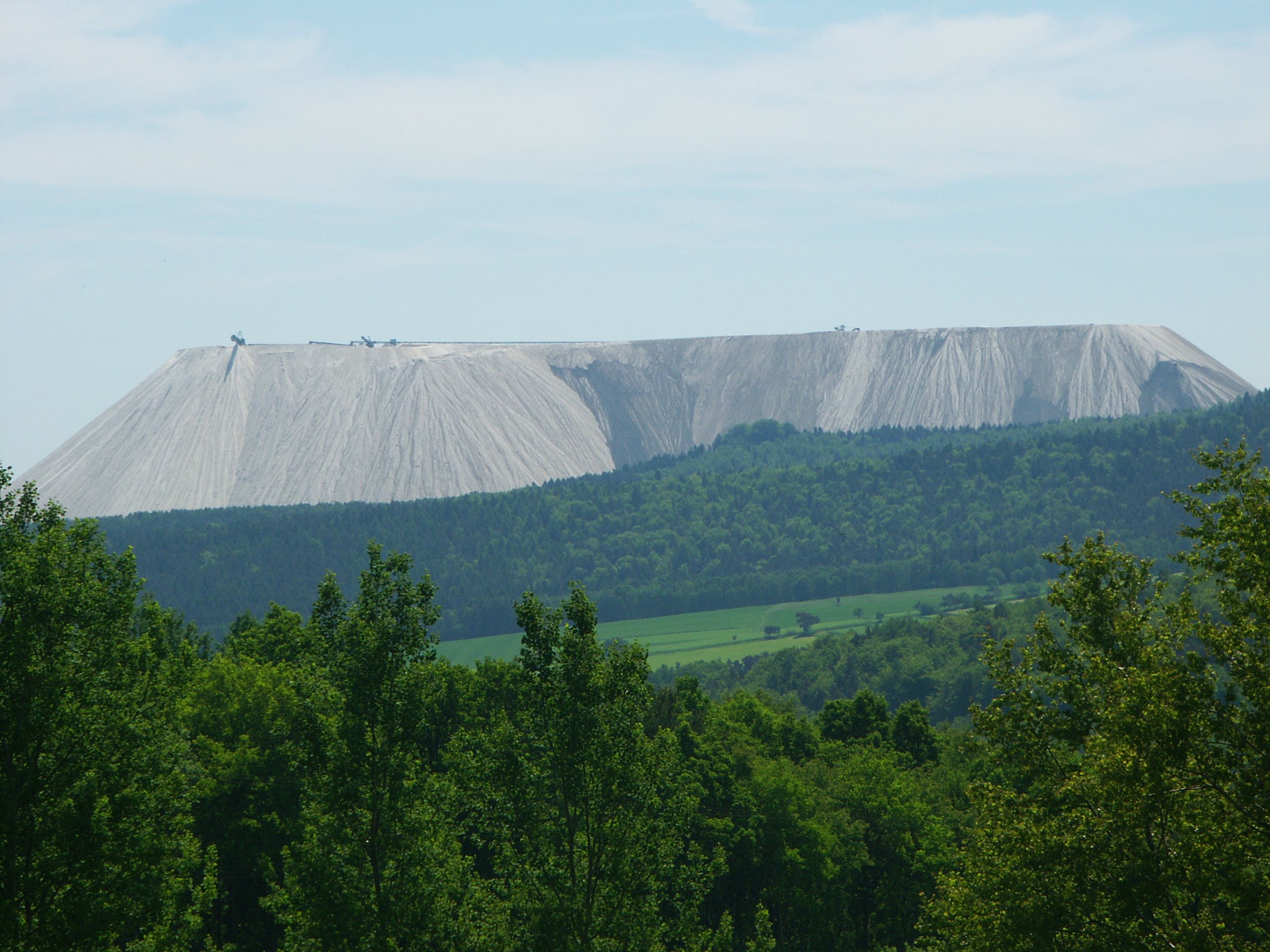
Monte Kali and Kalimanjaro are local colloquial names for the spoil heap or spoil tip that towers over the town of Heringen, Hesse, Germany. It is one of a number of sites where the K+S chemical company dumps sodium chloride (common table salt), a byproduct of potash mining and processing, a major industry in the area.
| Monte Kali | |
|---|---|
 Monte Kali and Hornungskuppe hill | |
| Highest point | |
| Elevation | 520 m (1,710 ft)[1] |
| Prominence | 132 m (433 ft)[2] |
| Coordinates | 50°54′17″N 9°59′20″E |
| Geography | |
| Location | Heringen, Hesse, Germany |
The names are puns of Kali (shorthand for Kalisalz, German for "potash") on "Monte Carlo" and "Kilimanjaro." The heap lies directly next to the border with the state of Thuringia, and hence next to the former inner German border with what was once East Germany.[3]

The heap rises over 250 metres (820 ft) above the surrounding land, its summit reaching 520 metres (1,710 ft) above sea level.[1] According to the Werra Potash Mining Museum in Heringen, Monte Kali has been in operation since 1976; as of August 2016, it covered 98 hectares (240 acres) and contained approximately 201 million tonnes of salt, with another 900 tonnes being added every hour and 7.2 million tonnes a year.[4]
Ecological impact
The Werra river has become salty (≥500 mg/L chloride at Gerstungen, and 65 mg/L chloride at Bad Salzungen (measurement of June 2003). The legal limit is at 2,500 mg/L chloride, which is saltier than parts of the Baltic Sea. The groundwater has become salty as well.[5] The invertebrate fauna was reduced from 60–100 species to 3.[6] K+S are licensed to keep dumping salt at the facility until 2030.[4]
References
- "Information und Zahlen zum Monte Kali" (in German). City of Heringen (Werra). Retrieved 2021-10-10.
- over Friedewald (388 m) (Dreienberg, 524 m)
- Monte Kali on Google Satellite Maps
- "Information und Zahlen zum Monte Kali" [Information and Figures about Monte Kali] (in German). Werra Kalibergbau Museum, Heringen. January 2014. Retrieved 2014-09-24.
- "Kali Bergbau und Versalzung" [Potash Mining and Salination]. living-rivers.de (in German). Das Projekt Lebendige Werra [The Living Werra Project]. Retrieved 2021-12-11.
- "Ökologische Auswirkungen der Salzbelastung an der Werra" [Ecological effects of salt stress at the Werra] (PDF). living-rivers.de (in German). Das Projekt Lebendige Werra [The Living Werra Project]. Retrieved 2021-12-11.
External links
 Media related to Monte Kali at Wikimedia Commons
Authority control | |
|---|---|
| General |
|
| National libraries | |
На других языках
[de] Monte Kali (Heringen)
Als Monte Kali oder Kalimandscharo (abgeleitet von dem Kilimandscharo) wird eine sehr große Salzhalde des Kalibergbaus bezeichnet. Sie befindet sich bei Heringen (Werra) im Landkreis Hersfeld-Rotenburg nahe der hessisch-thüringischen Grenze im Kalirevier Werra, einem Bergbaurevier in Osthessen und Westthüringen. Die weithin sichtbare weiße Halde ist bis zu einer Höhe von 520 m ü. NHN genehmigt,[1] per Höhenlinie auf amtlichen Karten erreicht sie auf jeden Fall gesichertermaßen über 505 m ü. NHN.[2] Da sie überdies als Aussichtspunkt begangen werden kann, ist sie auch zu einer Touristenattraktion geworden.- [en] Monte Kali
Другой контент может иметь иную лицензию. Перед использованием материалов сайта WikiSort.org внимательно изучите правила лицензирования конкретных элементов наполнения сайта.
WikiSort.org - проект по пересортировке и дополнению контента Википедии