geo.wikisort.org - Mountains
Monte Elto is a mountain of Lombardy, Italy. It is located within the Bergamo Alps.
This article may be expanded with text translated from the corresponding article in Italian. (May 2010) Click [show] for important translation instructions.
|
| Monte Elto | |
|---|---|
 | |
| Highest point | |
| Elevation | 2,145 m (7,037 ft) |
| Coordinates | 46°03′21.41″N 10°17′55.49″E |
| Geography | |
 Monte Elto Italy | |
| Location | Lombardy, Italy |
| Parent range | Bergamo Alps |
Toponym
According to some interpretations, the name Elto derives from the Venetian term Elt which means high.[1]
Geography
Mount Elto is located on the western side of Val Camonica, north of the Concarena and in front of mount Adamello.[2] Its territory belongs to the municipalities of Sellero and Capo di Ponte.
The southern side is lapped by the Clegna stream, the northern one by the Allione stream. The Re di Sellero stream flows on the eastern side. All these waterways are tributaries of the Oglio.
 Monte Elto seen from Cevo (winter)
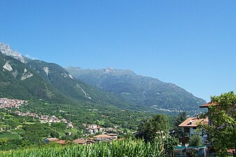 Monte Elto seen from Braone (summer)
 Monte Elto seen from Paspardo (summer)


References
- "Valle Camonica: i Paesi - Sellero". 2008-02-04. Archived from the original on 2008-02-04. Retrieved 2021-08-25.
- "SCHEDA". www.domeniconodari.it. Retrieved 2021-08-25.
This article about a mountain, mountain range, or peak located in Lombardy is a stub. You can help Wikipedia by expanding it. |
На других языках
- [en] Monte Elto
[it] Monte Elto
Il monte Elto è una montagna delle Prealpi bergamasche, alta 2147 m s.l.m..Текст в блоке "Читать" взят с сайта "Википедия" и доступен по лицензии Creative Commons Attribution-ShareAlike; в отдельных случаях могут действовать дополнительные условия.
Другой контент может иметь иную лицензию. Перед использованием материалов сайта WikiSort.org внимательно изучите правила лицензирования конкретных элементов наполнения сайта.
Другой контент может иметь иную лицензию. Перед использованием материалов сайта WikiSort.org внимательно изучите правила лицензирования конкретных элементов наполнения сайта.
2019-2026
WikiSort.org - проект по пересортировке и дополнению контента Википедии
WikiSort.org - проект по пересортировке и дополнению контента Википедии