geo.wikisort.org - Mountains
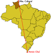
Monte Caburaí is a mountain located on the border between the South American countries of Brazil and Guyana standing at 1,465 metres (4,806 ft) above sea level. The source of the Ailã river (or Uailã river), located on the mountain, is the northernmost point of Brazil.[1]
| Monte Caburaí | |
|---|---|
| Highest point | |
| Elevation | 1,465 m (4,806 ft) |
| Coordinates | 05°16′20″N 60°12′43″W |
| Geography | |
| Location | Roraima, Brazil - Guyana |
See also
- Extreme points of Brazil
References
- "Brasil em síntese - território - dados geográficos". IBGE (in Portuguese). Retrieved 2022-10-04.
 | This Roraima, Brazil location article is a stub. You can help Wikipedia by expanding it. |
На других языках
- [en] Monte Caburaí
[fr] Mont Caburaí
Le mont Caburaí est un relief culminant à 1 414 mètres d'altitude à la frontière entre le Brésil, plus précisément la municipalité (município) d'Uiramutã dans l'État du Roraima, et le Guyana.[it] Monte Caburaí
Il monte Caburaí è un monte del Massiccio della Guiana alto 1.465 m al confine tra Brasile e Guyana.Текст в блоке "Читать" взят с сайта "Википедия" и доступен по лицензии Creative Commons Attribution-ShareAlike; в отдельных случаях могут действовать дополнительные условия.
Другой контент может иметь иную лицензию. Перед использованием материалов сайта WikiSort.org внимательно изучите правила лицензирования конкретных элементов наполнения сайта.
Другой контент может иметь иную лицензию. Перед использованием материалов сайта WikiSort.org внимательно изучите правила лицензирования конкретных элементов наполнения сайта.
2019-2026
WikiSort.org - проект по пересортировке и дополнению контента Википедии
WikiSort.org - проект по пересортировке и дополнению контента Википедии