geo.wikisort.org - Mountains
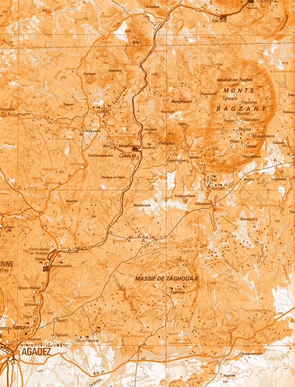
Mont Idoukal-n-Taghès (also Mont Bagzane, Mont Bagzan) is the highest mountain in Niger. Mont Idoukal-n-Taghès is located in the south central Aïr Mountains, and is at the northern end of the Bagzane plateau. The village and pilgrimage site of Abatol sits at the base of the peak.[2] The Aouderas valley, the path of a seasonal wash (or Kouri) runs south from the foot of Idoukal-n-Taghès towards Agadez, the regional capital. The oasis town of Aouderas is just southwest of the mountain. Due to its high elevation, mount Idoukal'n'Taghes has been found to host a number of Saharan-Mediterranean and Tropical plant species that have never been recorded elsewhere in Niger.[3]
| Mont Idoukal-n-Taghès | |
|---|---|
 Mont Idoukal-n-Taghès Location of Mont Idoukal-n-Taghès in Niger | |
| Highest point | |
| Elevation | 2,022 m (6,634 ft) |
| Listing | Country high point |
| Coordinates | 17°50′21″N 8°43′13″E[1] |
| Geography | |
| Location | Niger |
| Parent range | Aïr Mountains |
Official Nigerien and international sources believed Mont Gréboun, far to the north, to be the highest peak in the nation as late as 2001, when Gréboun's long standing lower measurement confirmed at 1944 m, which had variously been measured as high as 2310 m.[4] Greboun has a much greater local relief, rising from near the desert floor, while Idoukal-n-Taghès sits atop a high massif with an average altitude above 1600 meters.
To honour the highest point in Niger, the official aircraft of the President of Niger is named Mont Bagzane.[5]
References
- 17.839033,8.720183 and mapper.acme.com N 17 50' 21" E 8 43' 13"
- The Nigerian Field Society: Lagos Branch. Trip to Niger Republic, October 2003 Archived 2008-05-19 at the Wayback Machine
- Anthelme, F.; Waziri Mato, M.; Maley, J. (2008). "Elevation and local refuges ensure persistence of mountain specific vegetation in the Nigerien Sahara". Journal of Arid Environments. 72 (12): 2232–2242. doi:10.1016/j.jaridenv.2008.07.003.
- Peakbagger listing. Compare Jolijn Geels (2006) pp 177, 183-84 and Decalo (1997) p. 216.
- Photos of the Boeing 737-2N9C numbered 5U-BAG, with readable title on nose.
External links
- View of Mont Bagzane (2004)
- View of Mont Bagzane, Jensen Young (nd)
- Idoukal n'Taghes, le plus haut sommet des Monts Bagzans (2007).
- Swedish travelogue, including image from top of peak (2006).
- bagzanvoyages.free.fr Travel guide :: Detailed topographic map of the area.
На других языках
[de] Idoukal-n-Taghès
Der Idoukal-n-Taghès ist mit einer Höhe von 2022 m der höchste Berg Nigers. Er gehört zu den Monts Bagzane, einem Massiv im Süden des Hochgebirges Aïr, und wird deshalb auch als Mont Bagzane bezeichnet. Der halbmondförmige Berg ist vulkanischen Ursprungs.- [en] Mont Idoukal-n-Taghès
[fr] Mont Indoukat-n-Taglès
Le mont Indoukat-n-Taglès[1] (variantes orthographiques : Indoukal[2], Taghès) est une montagne du Niger, point culminant du pays et du massif de l'Aïr. Son altitude est de 2 022 mètres.[it] Mont Idoukal-n-Taghès
Il Mont Idoukal-n-Taghès è una montagna dell'Africa occidentale, situata in Niger. Viene chiamato anche Mont Bagzane o Mont Bagzan.[ru] Идукальн-Тагес
Идукальн-Тагес — самая высокая гора в Нигере высотой 2022 м. Расположена в северной части горного массива Багзане на юге высокогорья Аира. Гора в форме полумесяца имеет вулканическое происхождение.Другой контент может иметь иную лицензию. Перед использованием материалов сайта WikiSort.org внимательно изучите правила лицензирования конкретных элементов наполнения сайта.
WikiSort.org - проект по пересортировке и дополнению контента Википедии