geo.wikisort.org - Mountains
Meskheti Range (Georgian: მესხეთის ქედი) (Meskh/Meskhet/Meskhetian Range, Adzhar-Imereti Range, Achara-Imereti Range Adzhar-Akhaltsikh Range also Moschian Mountains) is a part of the Lesser Caucasus mountain range in Meskheti region, in southwestern Georgia.
This article needs additional citations for verification. (February 2022) |
| Meskheti Range | |
|---|---|
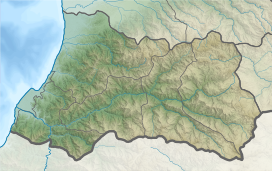
 View of Meskheti Range near Abastumani, Georgia | |
| Highest point | |
| Peak | Mount Mepistskharo |
| Elevation | 2,850 m (9,350 ft) |
| Dimensions | |
| Length | 150 km (93 mi) |
| Geography | |
   | |
| Country | |
| Range coordinates | 41°50′26″N 42°39′47″E |
| Parent range | Caucasus Mountains |
Geography
The length of the range is 150 km and the highest point is Mount Mepistskharo at an elevation of 2,850 m above sea level. The Meskheti Range is characterized by high amounts of precipitation. The territory around Mt. Mtirala (the Ajarian section of the range) was the wettest region within the Soviet Union and is the most humid area of the Caucasus with an annual precipitation of approximately 4500mm/year (180 inches/year). Several rivers are flowing from the Meskheti Range — Supsa, Acharis-Tsqali and Natanebi.
Flora and fauna
The slopes of the Meskheti Range are rich in endemic and relic species[1] and mainly covered by deciduous forests (oak, chestnut, maple, hornbeam, beech) below 1,200 m above sea level and by coniferous forests (spruce, fir and in some cases pine) from 1,200 to 1,800 m. The highest regions of the range are covered by sub-alpine and alpine meadows.
Strabo mentions the Moschian Mountains as joining the Caucasus. (Geography, 11.2.1)
14% of Meskheti range territory is included in three Georgian national parks — Borjomi-Kharagauli, Kintrishi and Mtirala national parks.[1]
See also
References
- Levan Mumladze, Giorgi Chaladze, Zezva Asanidze, Salome Saghinadze, Ema Khachidze Refugial Forest from the Western Lesser Caucasus 2008
This Georgia location article is a stub. You can help Wikipedia by expanding it. |
На других языках
[de] Meschetisches Gebirge
Das Meschetische Gebirge (georgisch მესხეთის ქედი); auch Adscharo-Imeretisches Gebirge; (russisch Месхетский хребет, Аджаро-Имеретинский) bildet den westlichen Teil des Kleinen Kaukasus.- [en] Meskheti Range
[ru] Месхетский хребет
Месхетский хребе́т (груз. მესხეთის ქედი) — горный хребет в Грузии, в северной части Малого Кавказа. Протяжённость с запада на северо-восток — около 240 км. Наибольшая высота — 2850 м (Меписцкаро).Другой контент может иметь иную лицензию. Перед использованием материалов сайта WikiSort.org внимательно изучите правила лицензирования конкретных элементов наполнения сайта.
WikiSort.org - проект по пересортировке и дополнению контента Википедии