geo.wikisort.org - Mountains
Meili Xue Shan (Chinese:梅里雪山, translation: "Mainri snowy range") or Mainri Snow Mountains (Tibetan: སྨན་རི།) is a mountain range in the Chinese province of Yunnan. It lies close to the northwestern boundary of the province and is bounded by the Salween River on the west and the Mekong on the east. The Meili are subrange of the larger Nu Mountains, themselves a constituent range of the Hengduan group.
| Meili Snow Mountains | |
|---|---|
 | |
| Highest point | |
| Peak | Kawagebo |
| Elevation | 6,740 m (22,110 ft) |
| Coordinates | 28°26′14″N 98°41′04″E |
| Dimensions | |
| Length | 200 km (120 mi) North-south |
| Width | 30 km (19 mi) East-west |
| Area | 6,000 km2 (2,300 sq mi) |
| Naming | |
| Native name | 梅里雪山 (Chinese) |
| Geography | |
 Meili Snow Mountains | |
| Country | China |
| State | Yunnan |
| Rivers | Salween and Mekong |
| Settlement | Deqen is the closest settlement of considerable size |
| Parent range | Hengduan Mountain |
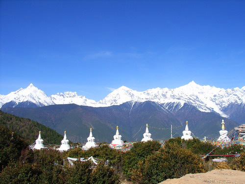
The crest of the range rises to over 6,000 metres (20,000 ft) above sea level, making for impressive prominence over the river valleys to the east and west, which are between 1,500 metres (4,900 ft) and 1,900 metres (6,200 ft) in elevation. The highest peak is Kawagarbo, which rises to 6,740 metres (22,110 ft). Kawagarbo is considered sacred for Tibetan Buddhists. Other significant peaks include Mianzimu, Cogar Laka and Jiariren-an. Because of restrictions and dangerous conditions, none of the major peaks in the range have ever been summited.
Name
In Tibet, people usually call the mountain by its peak Kawagarbo or Taizi(Prince) Snow Mountain.
In Tibetan, "Meili/Mainri" means mountains of herbs. People named the mountain "Meili/Mainri" because of the valuable herbs on this mountain.[1]
Main Peaks


Meili Snow mountain has 13 main peaks. They are also called "Taizi(Prince) Thirteen Peaks".
- Kawagarbo (6,740m)
- Also called Taizi(Prince) Peak.
- Mianzimu (6,054m)
- Also called God Daughter(Queen)Peak.
- Jiariren-an (5,470.5m)
- Five Budda Peak
- Bujiong SongJie Wuxue (approximately. 6,000m)
- Also called Son Peak.
- Lora Zangui Gonbu (5,229m)
- The main peak of Meili Snow Mountain geographically
- Bawu Bameng (6,000m)
- Paba Niding Jiuzhao (5,880m)
- Mabing Zhala Wangdui (6,365m)
- Nairi Dingka (6,379m)
- Cogar Laka (5,993m)
- Zhala Queni (5,640m)
- Badui (5,157m)
- Zhandui Wuxue(6,400m)
History
Expedition Records
- 1987, from August to September, Joetsu Alpine Club abandoned the expedition due to continuous avalanches. (Height: 5,100m) Direction: Mingyong Glacier[2]
- 1988, American Expedition team led by Nicholas Clinch abandon their expedition. (Height: 4,350m) Direction: Mingyong Glacier[2]
- 1989, September to November, a joint expedition team of Chinese and Academic Alpine Club of Kyoto University(AACK) was created and made their first attempt. (Height: 5,500m) Direction: Yubeng[3][2]
- 1990, November to 1991 January, the joint expedition team made their second attempt and lost their lives in an avalanche. (Height: 6,470m) Direction: Yubeng[3][2]
- 1991, January, avalanche rescue team led by Chinese Mountaineering Association(CMA) reached C2 camp at 5,300m and abandoned their rescue mission on January 21th due to snow cover.[3][2]
- 1991, April to June, a joint search team of Chinese and Japanese abandoned their search mission due to multiple snow storms and avalanches.[2]
- 1996, October to December, a new joint expedition team by Chinese and Japanese challenged again, but remained unsuccessful due to extreme weather. (Height: 5,300) Direction: Yubeng[2]
The Prohibition of the Expedition
Kawagarbo(Meili Snow Mountain) is known as the sacred mountain in Tibetan Culture. The local people believe the climbing activities on the mountain is a blasphemy and the accidents that happened in the past is the anger of the gods. Considering from both the perspective of the local culture and the safety of the expedition, the local government has decided to stop climbing activities on Meili Snow Mountain.[2]
- 2000, an international meeting was held between the government of Yunnan Province and The Nature Conservancy(TNC). The meeting had made an appeal to prohibit any climbing activities on Kawagarbo.[2]
- 2001, a law was passed by local government that no climbing activities is then allowed on Kawagarbo.[2]
Climate
Temperature
The average temperature in Meili Snow Mountain Area has had a trend of increasing each year since 1990.[4]
The temperature of the area is distributed by the mountain range that splits the area into west and east. The temperature on the North-West side increases the most while the east remains mostly the same across the whole year. The increasing trend of temperature in the Meili Snow Mountain range has a strong correlation with the elevation. At an area higher than 4,000m, the temperature's increasing trend gets larger per meter. [4]
Precipitation
The precipitation has a huge trend of decreasing each year. Most of the precipitation is in summer while winter has the least.[4]
The monsoon period contributes the most to the annual precipitation. Approximately 67% of the precipitation is in the Monsoon period. Among all the observations since 1990, the precipitation in Spring has decreased by 10% in total. The amount of precipitation also has a strong correlation with the elevation. During the monsoon period, the precipitation decreases as the elevation gets lower on the west side of the mountain range. However, the precipitation raises tremendously on the east side of the mountain where the elevation is below 3,700m.[4]
Climate Change
Due to the increasing trend of temperature and the decreasing trend of precipitation, the Meili Snow Mountain range is facing a huge challenge that its glacier water resource is getting scarcer annually. Protecting the environment and preventing the area from losing its water resource becomes more important each year. The environmental protection in Meili Snow Mountain could be decisive to its biome system.[4]
References
- Chang jian Zang yu ren ming di ming ci dian = Dictionary of common Tibetan personal and place names. Guansheng Chen, Caidan An, 陈观胜., 安才旦. (Di 1 ban ed.). Beijing Shi: Wai wen chu ban she. 2004. ISBN 7-119-03497-9. OCLC 65173194.
{{cite book}}: CS1 maint: others (link) - Bairi setsuzan : Jūshichinin no tomo o sagashite. Naoyuki Kobayashi, 尚礼 小林. Tōkyō: Yama To Keikokusha. 2006. ISBN 4-635-28065-9. OCLC 675441024.
{{cite book}}: CS1 maint: others (link) - "AAC Publications - East of the Himalaya, Part II: Three Rivers Gorges of the Hengduan Mountains". publications.americanalpineclub.org. Retrieved 2022-10-06.
- Wen-Fei, Miao; Shi-Yin, L. I. U.; Yu, Z. H. U.; Shi-Mei, Duan; Feng-Ze, H. a. N. (2022-05-30). "Spatio-temporal differentiation and altitude dependence of temperature and precipitation in Meili Snow Mountains". Advances in Climate Change Research. 18 (3): 328. doi:10.12006/j.issn.1673-1719.2021.207. ISSN 1673-1719.
На других языках
- [en] Meili Snow Mountains
[fr] Monts Meili Xue
Les monts Meili Xue (tibétain : སྨན་རི།, Wylie : sman ri, THL : men ri (Mainri) ; chinois simplifié : 梅里雪山 ; pinyin : méilǐ xuěshān ; litt. « mont enneigée Meili ») sont un massif montagneux dont le point culminant est le Kawa Karpo culminant à 6 740 mètres d'altitude. Ils font partie des monts Hengduan, à la jonction entre le xian de Dêqên, préfecture autonome tibétaine de Dêqên, dans la province du Yunnan, et la région autonome du Tibet, en République populaire de Chine. Ils sont classés par l'office du tourisme chinois en catégorie AAAA.Другой контент может иметь иную лицензию. Перед использованием материалов сайта WikiSort.org внимательно изучите правила лицензирования конкретных элементов наполнения сайта.
WikiSort.org - проект по пересортировке и дополнению контента Википедии