geo.wikisort.org - Mountains
Meall Dubh (789 m) is a mountain in the Northwest Highlands, Scotland. Lying near the village of Fort Augustus, it is the highest peak between the valleys of Glen Moriston and Glen Garry.
| Meall Dubh | |
|---|---|
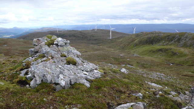 Meall Dubh summit | |
| Highest point | |
| Elevation | 789 m (2,589 ft)[1] |
| Prominence | 544 m (1,785 ft) |
| Listing | Corbett, Marilyn |
| Coordinates | 57°07′41″N 4°54′02″W |
| Geography | |
| Location | Highland, Scotland |
| Parent range | Northwest Highlands |
| OS grid | NH245078 |
| Topo map | OS Landranger 34 |
Surrounded by moorland, a wind farm has been constructed on its slopes. The easiest route to the summit of Meall Dubh is from its northern Glen Moriston side[2]
References
- "Meall Dubh". hill-bagging.co.uk. Retrieved 7 May 2019.
- "walkhighlands Meall Dubh". walkhighlands.co.uk. Retrieved 7 May 2019.
This Scottish location article is a stub. You can help Wikipedia by expanding it. |
Текст в блоке "Читать" взят с сайта "Википедия" и доступен по лицензии Creative Commons Attribution-ShareAlike; в отдельных случаях могут действовать дополнительные условия.
Другой контент может иметь иную лицензию. Перед использованием материалов сайта WikiSort.org внимательно изучите правила лицензирования конкретных элементов наполнения сайта.
Другой контент может иметь иную лицензию. Перед использованием материалов сайта WikiSort.org внимательно изучите правила лицензирования конкретных элементов наполнения сайта.
2019-2026
WikiSort.org - проект по пересортировке и дополнению контента Википедии
WikiSort.org - проект по пересортировке и дополнению контента Википедии