geo.wikisort.org - Mountains
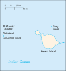
The McDonald Islands (53°3′34.9″S 72°35′32.2″E) are an uninhabited archipelago in the southern Indian Ocean in the vicinity of Heard Island (53°06′S 73°31′E). Together with Heard Island, they make up the Australian external Territory of Heard Island and McDonald Islands. The McDonald Islands are the emergent peaks of submarine volcanoes and are Australian external territory. Prior to 1992, there had not been an eruption in the previous 75,000 years.
| McDonald Islands | |
|---|---|
| Highest point | |
| Elevation | 230 m (750 ft) |
| Geography | |
| Location | Heard Island and McDonald Islands, Australia |
| Geology | |
| Mountain type | Complex volcano |
| Last eruption | July 2005 |

Morphology
The McDonald Islands comprise three islands: McDonald Island, Flat Island (which later merged with McDonald Island) and Meyer Rock. The islands are mostly composed of phonolitic low-silica pumice, dikes and lava domes, and sit atop a submarine plateau, the Kerguelen Plateau. They are located about 75 km from Heard Island.
McDonald Island is the largest of the islands, at around 1 square kilometre (250 acres) in area. It has been the main focus of volcanic activity in recent times. Prior to 1996, McDonald Island had been a flat green island whose pumice beaches provided a great nesting area for penguin breeding. The island now has two main peaks, Maxwell Hill and Samarang Hill – the highest is Maxwell Hill at 230 metres (750 ft).
Eruptions
Prior to 1992, no eruptions had taken place at the McDonald Islands volcano for 75,000 years. A series of eruptions started in 1992.
1992 eruption
The first recorded eruption from the McDonalds was from a submarine vent (a small VEI-0 eruption) in December 1992. The eruption was probably the cause of pumice that washed up on the shore of Heard Island.
1996–1997 eruption
Fresh eruptions were reported in December 1996 when a vapour plume was noticed by an aeroplane pilot.
The plume was thought to have originated from Heard Island's Big Ben cone. However, on 18 March 1997 the crew of a passing ship heading for Heard Island reported that steam rose vigorously from a fissure on McDonald Island's steep north face; steam also vented from the island's north summit. Steam vented from a rubble-covered slope, indicating that a lava flow or pyroclastic flow had occurred.
On 2 April 1997, the crew of another ship noted that steam continued to vent from the fissure, rising from the summit and flanks of the island. That crew also observed lava flows travelling down gullies; the lava flows covered a significant area of the north part of the island. Sulphur deposits were also discovered and fresh pumice washed up on Heard Island. The eruption is estimated to have ended sometime in January–March 1997.
2001 eruption
Another eruption started at McDonald Island in 2001. The eruption was first sighted from a ship passing by the islands. Material was being ejected from the flanks of the island and also in the north and northwest of the island, and steam was issuing from near the summit crater. Work suggested that prior to the ship's visit, the volcano had been erupting, covering the island in dark, smooth material. Many features had been filled in, such as Williams Bay. The eruptions had also joined Flat Island to McDonald Island as 400 metres (1,300 ft) of land had been added to windward point. A new volcanic cone had also been created. An observation made in November 2002 noted two new lava domes had been formed; their date of formation is unknown.
2005 eruption
Analysis of satellite imagery noted that an eruption took place on 12 July 2005 on the northwest shore of the island. The eruption may have added a small portion to the area of the island.
Heritage
In 2002 the Heard Island and McDonald Islands were declared a marine reserve; this was expanded in 2014.[1] The islands are also recognised as a World Heritage Site.[2]
Notes
- Heard Island and McDonald Islands Marine Reserve Expansion Australian Antarctic Division. 29 March 2014.
- World heritage Australian Antarctic Division. 28 February 2005.
References
External links
| Authority control |
|
|---|
На других языках
[de] McDonald-Inseln
Die McDonald-Inseln sind eine kleine unbewohnte Inselgruppe im südlichen Indischen Ozean 427 Kilometer südöstlich der französischen Kerguelen. Zusammen mit der 43 Kilometer östlich gelegenen Insel Heard und dem Meeresgebiet rund um die Inseln bilden sie das australische Territorium Heard und McDonaldinseln.- [en] McDonald Islands
[fr] Îles McDonald
Les îles McDonald forment un petit archipel d'Australie situé dans le sud de l'océan Indien, entre l'Australie, Madagascar et l'Antarctique, dans le territoire extérieur des îles Heard-et-MacDonald. Les îles McDonald se composent de l'île McDonald et du rocher Meyer, anciennement de Flat Island qui a fusionné avec l'île McDonald à la faveur d'éruptions volcaniques entre novembre 2000 et novembre 2001[2].Другой контент может иметь иную лицензию. Перед использованием материалов сайта WikiSort.org внимательно изучите правила лицензирования конкретных элементов наполнения сайта.
WikiSort.org - проект по пересортировке и дополнению контента Википедии