geo.wikisort.org - Mountains
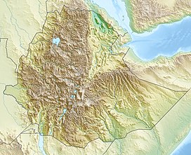
Manda Hararo is a group of basaltic shield volcanoes in east Africa whose last eruption was in 2009. The group is very large, spreading over 105 square kilometres (41 sq mi). At its northern end is a small example. South of this volcano is the Gumatmali-Gablaytu fissure system, an area dominated by fissure-fed lava flows. At the centre of the complex rise two volcanoes. Manda Hararo's large size is because it is a raised block from the end of a mid-ocean ridge spreading center. It is known for its rare basalts.
This article has multiple issues. Please help improve it or discuss these issues on the talk page. (Learn how and when to remove these template messages)
|
| Manda Hararo | |
|---|---|
 Satellite image of Manda Hararo | |
| Highest point | |
| Elevation | 600 m (2,000 ft) |
| Coordinates | 12°10′0″N 40°49′0″E[1] |
| Geography | |
| Geology | |
| Mountain type | Shield Volcanoes |
| Last eruption | June to July 2009 |
Eruptions
2007 eruption
Manda Hararo first erupted on August 13, 2007. NASA's Aura Satellite detected a large sulfur dioxide plume over Ethiopia and Sudan. Satellite imagery showed a lava flow emitted by Manda Hararo. Local residents reported that no precursors to the eruption had taken place. The first sign was a sudden, heavy, cracking sound, with only a slight tremor. At 17:30, fire was seen coming from Manda Hararo, "lighting up the entire area." Locals evacuated while the violent eruptions continued for three days. After the main eruption, lava flows continued and much of the fissure gave off strong fumarolic activity. On August 20, a team of scientists visited the area.
2009 eruption
On 29 June another plume was detected from the same area. Imagery showed thermal anomalies coming from Manda Hararo. A team of field scientists reached the site on 4 July and found the eruption had produced basaltic lava flows from fissures 4–5 kilometres (2.5–3.1 mi) long. The fissures were lined by scoria 'ramparts'. The eruption was possibly bigger than the 2007 eruption. By the time the scientists reached the fissure, it only emitted steam.
References
- "Manda Hararo". Global Volcanism Program. Smithsonian Institution.
- Volcano Live John Search, www.volcanolive.com
На других языках
[de] Manda Hararo
Der Manda Hararo ist ein 105 km × 30 km großer vulkanischer Komplex in Äthiopien. Er befindet sich im Süden des Afargebiets in der Kaloebene und südöstlich des Dabbahu.[1][2]- [en] Manda Hararo
[fr] Manda Hararo
Le Manda Hararo est un complexe volcanique d'Éthiopie qui fait partie de la vallée du Grand Rift.Другой контент может иметь иную лицензию. Перед использованием материалов сайта WikiSort.org внимательно изучите правила лицензирования конкретных элементов наполнения сайта.
WikiSort.org - проект по пересортировке и дополнению контента Википедии
