geo.wikisort.org - Mountains
Maljen (Serbian: Маљен) (pronounced [mâʎɛn]) is a mountain in western Serbia, just south of the city of Valjevo. It is well known as a summer and winter resort. The highest peak is Kraljev Sto, at 1,104 m (3,622 ft) above sea level, followed by Crni Vrh at 1,096 m (3,596 ft). On Maljen is situated resort Divčibare with 3 hotels, 24 holiday camps, two mountain lodges and two ski trails. During summer the slopes of the mountain are covered with flower meadows with white daffodils.[1]
| Maljen | |
|---|---|
 View from Crni Vrh | |
| Highest point | |
| Elevation | 1,104 m (3,622 ft) |
| Coordinates | 44°07′09″N 20°01′22″E |
| Geography | |
 Maljen Location in Serbia | |
| Location | Western Serbia |
After the successful 21st century program of brown bears protection on the Tara mountain, some 100 km (62 mi) to the southwest, by the 2020s bears re-appeared on the Maljen, too.[2]
Crna Reka Canyon
The canyon of the Crna Reka river is located just below the Divčibare resort, to the north. A 12.5 km (7.8 mi) long path into the canyon, which includes hiking, descending or walking through water, was adapted for tourists. It starts at the Ljuti Krš peak, under which the river springs. The sides are very steep, at some sections almost vertical and are carved in the black magmatic rocks. There is a small waterfall at the entrance into the canyon and, though small, the river creates shallows, falls and ponds. The total descent is 500 m (1,600 ft). The canyon, which is some 120 km (75 mi) southwest from Belgrade, is protected by the state as the natural reserve.[3]
 Maljen - Divčibare - Top of Paljevine
 Maljen - Divčibare - Top of Crni Vrh - Place Tometino polje
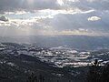 Maljen - Divčibare - Place Tometino Polje
 Maljen - Divčibare - Top Golubac - panorama
 Maljen - Divčibare - Top Golubac - panorama
 Maljen - Divčibare - Old house in top Golubac
 Source of the River Crna reka - place Ljuti krš
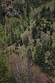 Place Ljuti krš
 Top of Golubac - View in Kraljev sto
 Top of Crni vrh - panorama
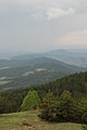 Top of Crni vrh - panorama
 Top of Crni vrh - panorama
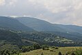 Mountain Maljen - south-east
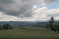 Mountain Maljen - south-east
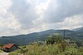 Mountain Maljen - south-east
 Mountain Maljen - south-east
 Mountain Maljen - south-east
 Mountain Maljen - south-east


References
- NATURE OF SERBIA - Holiday on the move. Belgrade: National Tourism Organisation of Serbia. 2013. p. 52. ISBN 978-86-6005-295-9.
- Slobodan Ćirić (14 August 2020). Мрки медвед у ваљевском крају [Brown bear in Valjevo area]. Politika (in Serbian).
- Dana Stanković (27 August 2017), "Biser netaknute prirode", Politika-Magazin, No. 1039 (in Serbian), pp. 20–21
Sources
- 39 Maljen–Suvobor
- Divčibare - pet šafrančića za jod u vazduhu! EkoSfera 2008-07-07
This Serbia location article is a stub. You can help Wikipedia by expanding it. |
На других языках
- [en] Maljen
[fr] Maljen
Le mont Maljen (en serbe cyrillique : Маљен) est une montagne de l'ouest de la Serbie. Son point culminant, le pic de Kraljev sto, s'élève à une altitude de 1 103 m.Другой контент может иметь иную лицензию. Перед использованием материалов сайта WikiSort.org внимательно изучите правила лицензирования конкретных элементов наполнения сайта.
WikiSort.org - проект по пересортировке и дополнению контента Википедии