geo.wikisort.org - Mountains
Lysá hora (Czech pronunciation: [ˈlɪsaː ˈɦora]; Polish: Łysa Góra; German: Lysa-berg, Kahlberg) is the highest mountain of the Moravian-Silesian Beskids range in the Czech Republic and also of the historical region of Cieszyn Silesia. It is one of the rainiest places of the country with an annual precipitation of over 1,500 mm (60 in). It is the 26th highest mountain in the country.
| Lysá hora | |
|---|---|
 | |
| Highest point | |
| Elevation | 1,323 m (4,341 ft) |
| Prominence | 768 m (2,520 ft) |
| Isolation | 54 km (34 mi) |
| Coordinates | 49°32′45″N 18°26′51″E |
| Naming | |
| Etymology | Bald mountain |
| Geography | |
 Lysá hora Location in the Czech Republic | |
| Location | Krásná, Moravian-Silesian Region, Czech Republic |
| Parent range | Moravian-Silesian Beskids |
| Geology | |
| Mountain type | Godulian Sandstone |
| Climbing | |
| Easiest route | paved road |
Etymology
The name means 'bald mountain'; the name came from the fact that Lysá hora had no trees. The place was first mentioned in a written document from 1261 as Lissa huera.
Climate
| Climate data for Lysá hora (1991−2020 normals, extremes 1980−present) | |||||||||||||
|---|---|---|---|---|---|---|---|---|---|---|---|---|---|
| Month | Jan | Feb | Mar | Apr | May | Jun | Jul | Aug | Sep | Oct | Nov | Dec | Year |
| Record high °C (°F) | 14.5 (58.1) |
12.7 (54.9) |
16.1 (61.0) |
22.8 (73.0) |
26.3 (79.3) |
27.6 (81.7) |
29.0 (84.2) |
29.7 (85.5) |
26.9 (80.4) |
20.7 (69.3) |
13.8 (56.8) |
11.2 (52.2) |
29.7 (85.5) |
| Mean maximum °C (°F) | 5.1 (41.2) |
5.9 (42.6) |
10.1 (50.2) |
16.7 (62.1) |
21.1 (70.0) |
24.4 (75.9) |
25.7 (78.3) |
25.3 (77.5) |
20.0 (68.0) |
16.5 (61.7) |
10.0 (50.0) |
6.3 (43.3) |
26.8 (80.2) |
| Average high °C (°F) | −3.1 (26.4) |
−2.6 (27.3) |
0.5 (32.9) |
6.9 (44.4) |
12.3 (54.1) |
15.7 (60.3) |
17.7 (63.9) |
17.7 (63.9) |
12.1 (53.8) |
7.0 (44.6) |
1.7 (35.1) |
−2.1 (28.2) |
7.0 (44.6) |
| Daily mean °C (°F) | −5.0 (23.0) |
−4.8 (23.4) |
−2.0 (28.4) |
3.6 (38.5) |
8.5 (47.3) |
12.0 (53.6) |
13.9 (57.0) |
14.1 (57.4) |
9.2 (48.6) |
4.6 (40.3) |
−0.1 (31.8) |
−3.9 (25.0) |
4.2 (39.6) |
| Average low °C (°F) | −6.7 (19.9) |
−6.8 (19.8) |
−4.4 (24.1) |
0.5 (32.9) |
5.0 (41.0) |
8.4 (47.1) |
10.3 (50.5) |
10.6 (51.1) |
6.3 (43.3) |
2.3 (36.1) |
−1.7 (28.9) |
−5.6 (21.9) |
1.5 (34.7) |
| Mean minimum °C (°F) | −16.2 (2.8) |
−15.6 (3.9) |
−11.8 (10.8) |
−7.9 (17.8) |
−2.0 (28.4) |
1.9 (35.4) |
4.4 (39.9) |
4.3 (39.7) |
−0.1 (31.8) |
−5.6 (21.9) |
−9.6 (14.7) |
−13.9 (7.0) |
−18.9 (−2.0) |
| Record low °C (°F) | −29.9 (−21.8) |
−25.4 (−13.7) |
−22.8 (−9.0) |
−12.6 (9.3) |
−7.0 (19.4) |
−1.9 (28.6) |
0.2 (32.4) |
−1.0 (30.2) |
−4.9 (23.2) |
−12.0 (10.4) |
−17.8 (0.0) |
−33.0 (−27.4) |
−33.0 (−27.4) |
| Average precipitation mm (inches) | 136.0 (5.35) |
232.5 (9.15) |
127.4 (5.02) |
141.7 (5.58) |
163.9 (6.45) |
178.1 (7.01) |
216.7 (8.53) |
185.8 (7.31) |
180.9 (7.12) |
124.2 (4.89) |
101.8 (4.01) |
99.4 (3.91) |
1,888.5 (74.35) |
| Average precipitation days (≥ 1.0 mm) | 14.3 | 14.2 | 14.1 | 12.9 | 16.0 | 15.5 | 15.8 | 14.0 | 14.3 | 13.9 | 14.4 | 14.9 | 174.3 |
| Source: infoclimat.fr[1][better source needed] | |||||||||||||
Tourism
Today, the mountain is also a small ski resort and a popular place for hiking in summer, attracting casual hikers, and fans of Nordic walking, running, cross-country skiing, and alpine skiing. The area has also hosted various sports competitions.[2][3][4][5]
It is the site of the Ivančena stone mound erected as a memorial for the Scouts who were executed in April 1945 in Cieszyn, modern-day Poland, for their part in anti-Nazi resistance.
Gallery
 In summer
 Sunset
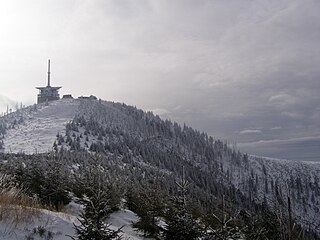 In winter


References
- "Normales et records pour la période 1991-2020 à Lysá hora". infoclimat.fr. Retrieved February 18, 2022.
- "Kilpi Beskydská sedmička 2020". Kilpi Beskydská sedmička 2020 (in Czech).
- "adrenalin cup" (in Czech). Archived from the original on 2019-03-28.
- "5 Beskydských vrcholů - Extrémní závod v Beskydech". www.5bv.cz (in Czech).
- "Lysacup :: Lysacup - poznej svůj limit!". lysacup.cz (in Czech).
External links
- "Lysá Hora Mountain Center" (in Czech).
- "Lysá Hora website" (in Czech).
- "Lysá Hora webcam" (in Czech).
- "Magnet zážitků v Beskydech: Lysá hora" (in Czech).
| Authority control: National libraries |
|---|
This Moravian-Silesian Region location article is a stub. You can help Wikipedia by expanding it. |
На других языках
[de] Lysá hora (Beskiden)
Lysá hora (deutsch: Kahlberg, oberschlesisch: Gigula) ist der höchste Berg der Mährisch-Schlesischen Beskiden (1323 m ü. M.) mit vier kleineren bewaldeten Nebengipfeln. Er liegt vier Kilometer östlich von Ostravice.- [en] Lysá hora
[fr] Lysá hora
La Lysá hora est le point culminant des Beskides moravo-silésiennes et la plus haute montagne de la chaîne des Carpates sur le territoire de la République tchèque. La montagne fut le point culminant du protectorat de Bohême-Moravie entre 1939 et 1945. Le sommet se situe à 1 323 mètres d'altitude.[it] Lysá hora
Lysá hora (ˈlɪsaː ˈɦora; in polacco: Łysa Góra, in tedesco: Lysa-berg, Kahlberg, in slesiano: Gigula) è la montagna più alta della catena montuosa dei Beschidi Moravo-Slesiani, che sorge in Repubblica Ceca e nella Slesia di Cieszyn. È considerato il luogo più piovoso della nazione, con precipitazioni annue oltre i 1.500 mm.[ru] Лиса (гора)
Ли́са[2], или Лы́сая гора́[3] (чеш. Lysá hora — «Лысая гора», сил. Gigula) — самая высокая гора Моравско-Силезских Бескид в Чехии. Высота над уровнем моря — 1323 метров[3]. Популярна среди любителей активного отдыха, в зимнее время работает горнолыжный курорт.Другой контент может иметь иную лицензию. Перед использованием материалов сайта WikiSort.org внимательно изучите правила лицензирования конкретных элементов наполнения сайта.
WikiSort.org - проект по пересортировке и дополнению контента Википедии