geo.wikisort.org - Mountains
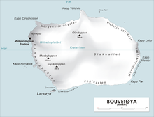
Lykketoppen,[1][2] occasionally anglicized as Lykke Peak, is a snow-covered, 765-meter (2,510 ft) tall summit that surmounts the southwest part of Bouvetøya, standing 1 nautical mile (2 km) east of Norvegia Point. It was first roughly charted in 1898 by a German expedition under Carl Chun, and was recharted and named in December 1927 by the First Norvegia Expedition under Captain Harald Horntvedt.[3]
References
- "Lykketoppen". Norwegian Polar Institute. Archived from the original on 6 March 2016. Retrieved 11 May 2012.
- Barr, Susan (1987). Norway's Polar Territories. Oslo: Aschehoug. p. 59. ISBN 82-03-15689-4.
- "Lykke Peak". Geographic Names Information System. Archived from the original on 12 May 2012. Retrieved 12 May 2012.
![]() This article incorporates public domain material from the United States Geological Survey document: "Lykke Peak". (content from the Geographic Names Information System)
This article incorporates public domain material from the United States Geological Survey document: "Lykke Peak". (content from the Geographic Names Information System)
This Bouvet Island location article is a stub. You can help Wikipedia by expanding it. |
На других языках
[de] Lykketoppen
Lykketoppen (norwegisch für Glücksgipfel) ist ein 766 m hoher Berg im Südwesten der Bouvetinsel im Südatlantik. Er ragt 1,5 km östlich der Landspitze Norvegiaodden auf.- [en] Lykketoppen
Текст в блоке "Читать" взят с сайта "Википедия" и доступен по лицензии Creative Commons Attribution-ShareAlike; в отдельных случаях могут действовать дополнительные условия.
Другой контент может иметь иную лицензию. Перед использованием материалов сайта WikiSort.org внимательно изучите правила лицензирования конкретных элементов наполнения сайта.
Другой контент может иметь иную лицензию. Перед использованием материалов сайта WikiSort.org внимательно изучите правила лицензирования конкретных элементов наполнения сайта.
2019-2026
WikiSort.org - проект по пересортировке и дополнению контента Википедии
WikiSort.org - проект по пересортировке и дополнению контента Википедии