geo.wikisort.org - Mountains
Lone Peak, a mountain peak southeast of Salt Lake City, Utah, United States is the center of the Lone Peak Wilderness, established in 1978. With an elevation of 11,260 feet (3,430 m), it is one of the taller peaks in the Wasatch Range along the Wasatch Front and tends to be a favorite hike. The first person in recorded history to successfully hike Lone Peak was Richard Bell, Sr. of Riverton, Utah. Richard also lead the first recorded climb of the Lone Peak Cirque. He went on to lead several expeditions and taught the first guides. Bell Canyon is still a common route to the summit, and was named after Richard Bell Sr. following his historic climb. Lone Peak consists almost entirely of quartz monzonite (a granitoid, or granite-like) rock of the 30.5 million year old Little Cottonwood Stock.[3][4][5] Quartzite and limestone are also found in distal locations on the mountain. The mountain from Little Cottonwood Canyon on the northern end to Corner Canyon on the southern end is called "Mount Jordan", the highest peak of which is Lone Peak, with other lower peaks being Enniss Peak and Bighorn Peak. The Peak ranks 98th on a list of Utah peaks with 500 feet (150 m) topographic prominence.[6][7]
| Lone Peak | |
|---|---|
 Summit of Lone Peak | |
| Highest point | |
| Elevation | 11,260 feet (3,432 m) NAVD 88[1] |
| Prominence | 893 ft (272 m)[2] |
| Coordinates | 40°31′37″N 111°45′22″W[1] |
| Geography | |
 Lone Peak Salt Lake County / Utah County, Utah, U.S. | |
| Parent range | Wasatch Range |
| Topo map | USGS Draper |
| Geology | |
| Mountain type | Quartz monzonite |
Hiking/Backpacking
| Lone Peak Hiking/Backpacking Details | |
|---|---|
| Summit: | 11,260 feet (3,432 m) |
| Estimated Starting Elevation: | 5,200 feet |
| Average Total Distance: | 11 miles round-trip |
| Time Needed: | 1–2 days |
| Rating: | Difficult |
It is possible to reach the summit in one long day, but rock climbers often camp at the base of the summit and non-climbers often camp lower on the Jacob's Ladder Trail. There are a few streams that dry up before summer, so water must be carried in. There is reputedly a spring that runs year-round.
Jacob's Ladder Trail
The trail head, located at 40°29′39″N 111°48′59″W, is marked with a sign. It is located near a large turnout on the right side of the road and three 4-wheel drive tracks climbing the road bank on the north side of the road. In 2007, the turnout was accompanied by a wooden fence leading to the starting point of the trail. Round trip mileage is about 11.1 miles with 5,603 feet of vertical gain.
Draper Ridge Trail
The Draper Ridge Trail is currently inactive. The trail is in a deteriorated condition, as the top of the trail is very exposed to weather. Towards the bottom, thick undergrowth prevents passage. The Jacob's Ladder Trailhead is just up the road. The Jacob's Ladder Trail overlaps the Draper Ridge Trail for the last 2/3 of the way to the peak.
Cherry Canyon Logging Trail
Important features of this trail are that it has a year-round spring (cold springs) located at 40°30′58″N 111°47′35″W and a small cabin in a meadow. The route gains altitude in the beginning, going through a steep scrub oak section. After a few hours of hiking, things change as the trail levels off and veers north into the trees crossing the water of cold springs in bear canyon.[citation needed] The trail climbs out of the drainage on the north side into a new drainage, but stays generally below the ridge line. The trail eventually opens into a meadow with a small cabin in the large pine trees. The trail continues up above the cabin to the southeast and crosses over to the south into another drainage at a low point on the ridge. The southeast top of the new drainage meets up with the main granite drainage running roughly north-south which leads to the Lone Peak Cirque via stacked rock cairns. An alternate route is to roughly follow the stream bed up the drainage until the top of the ridge that runs roughly north-south above a granite drainage is reached. Round trip mileage is about 16 miles with 6,876 feet of vertical gain.
Outlaw Cabin

The Outlaw Cabin, located at 40°31′12″N 111°46′53″W on the southwest side of a meadow, was constructed in the summer of 1960 by the Allen Brothers and Alan Summerhays. Construction was completed in 1967 prior to the area being designated as a wilderness area. The cabin has three cots, a pot belly stove, cabinets, and two small windows. It is built from trees downed in the area and the roof is lined with plastic and dirt/grass for insulation. All the materials besides the trees were hauled to the location by horseback. The cabin is partially hidden by large trees. In October 1997, a Draper family was caught in a blinding snow storm and took shelter in the cabin until they were rescued. There is a journal in the cabin that visitors can add their stories to.
Deaths on Lone Peak
- December 15, 1936 - Seven died when a Western Air Express Boeing 247[8] crashed just below Hardy Ridge on Lone Peak.[9] The major parts of the aircraft were hurled over the ridge and fell over a thousand feet into a basin below.[8]
- July 25, 2002 - Two hikers were struck by lightning near the summit of Lone Peak while they were trying to seek shelter.[10]
- September 8, 2015 - A woman fell 200–300 feet near the cirque. Her body was found the next day.[11]
- June 17, 2017 - An extreme trail runner fell about 500 feet near Bighorn Peak while approaching Lone Peak.[12]
Movie Rocks
- The 1968 film The Devil's Brigade was filmed in Utah. The attack on a Nazi mountain stronghold in Italy was filmed on the lower part of this peak's mountain at a place called "Movie Rocks". The trail leading there is just to the west of the Jacob's Ladder trail.
Images
 Lone Peak from Jacob's Ladder trail
 Looking South at Lone Peak and Question Mark Wall
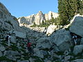 Scrambling may be required
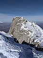 Summit in the winter
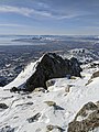 View of the Question Mark wall in the winter
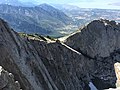 View towards Utah Valley and Utah Lake
 Lone Peak from Salt Lake Valley at night
 The south summit wall of Lone Peak


References
- "11251". NGS data sheet. U.S. National Geodetic Survey. Retrieved 2016-04-20.
- "Lone Peak, Utah". Peakbagger.com. Retrieved 2016-04-20.
- Crittenden, M.D., 1965, Geology of the Draper Quadrangle, Utah: U.S. Geological Survey Map GQ-377, scale 1:24,000.
- Crittenden, M.D., 1965, Geology of the Dromedary Peak Quadrangle, Utah: U.S. Geological Survey Map GQ-378, scale 1:24,000.
- Vogel T.A., Cambray, F.W., Constenius, K.N., 2001, Origin and emplacement of igneous rocks in the central Wasatch Mountains, Utah: Rocky Mountain Geology, v. 36, n. 2, pp. 119-162.
- "List "Utah Top 100 (500 ft. prom)"". ListsOfJohn.com. Retrieved 18 Apr 2016.
- "Some info about Lone Peak"". mountainproject.com. Retrieved 18 Nov 2020.
- Department of Commerce Aircraft Accident Report
- Confetti on Lone Peak, Time, June 21, 1937
- "Lightning deaths by location and activity since 1950". National Weather Service, Salt Lake Office, UT. Archived from the original on 2017-01-04. Retrieved 2016-04-18.
- "Missing hiker found dead in Draper, fell 200-300 feet". Fox13 Salt Lake City. Retrieved 2016-04-18.
- Press, Lehi Free (2017-06-21). "Zac Zimmerman dies in tragic hiking fall". Lehi Free Press. Retrieved 2018-09-30.
External links
| Wikimedia Commons has media related to Lone Peak (Utah). |
- "Lone Peak". SummitPost.org.
- Lone Peak. Climb-Utah.com.
- Hiking to Lone Peak Summit. Utahwild.com.
- Lone Peak Hiking Directions. UtahPictures.com
- Hiking Lone Peak. by Hyrum Wright.
На других языках
- [en] Lone Peak (Utah)
[ru] Лон-Пик
Лон-Пик (англ. Lone Peak) — вершина горы юго-востоку от Солт-Лейк-Сити, штат Юта. Её высота составляет 3430 метров. Лон-Пик является центром первого природного заповедника Юты. Заповедник был создан в 1978 году и включает в себя 12 000 га в хребте Уосатч. Гора представляет собой красивый огромный массив, который виден от Солт-Лейк-Сити до Прово[2].Другой контент может иметь иную лицензию. Перед использованием материалов сайта WikiSort.org внимательно изучите правила лицензирования конкретных элементов наполнения сайта.
WikiSort.org - проект по пересортировке и дополнению контента Википедии