geo.wikisort.org - Mountains
Lilienstein is a highly distinctive mountain in Saxon Switzerland, in Saxony, southeastern Germany, and was once the site of a Bohemian castle. It is one of the few table mountains on the east of the river Elbe and constitutes the symbol of the Saxon Switzerland National Park.
This article may be expanded with text translated from the corresponding article in German. (July 2010) Click [show] for important translation instructions.
|
| Lilienstein | |
|---|---|
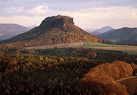 Lilienstein at sunset | |
| Highest point | |
| Elevation | 415.2 m (1,362 ft) |
| Coordinates | 50°55′52″N 14°05′05″E |
| Geography | |
 Lilienstein Saxony, Germany | |
| Geology | |
| Mountain type | Table |
| Type of rock | Sandstone |
Name
The name is not related to the flower lily (German: Lilie) but is probably derived from St. Gilgen or St. Ilgen (earlier names of the mountain were „Ylgenstein“ und „Illgenstein“). These names refer to Saint Giles.
Location
The Lilienstein is located 15 km east of Pirna and 5 km west of Bad Schandau. It overlooks the river Elbe, which forms a 180° loop around the mountain. The Königstein Fortress is located opposite on the left bank of the river.
This Saxony location article is a stub. You can help Wikipedia by expanding it. |
This Sächsische Schweiz-Osterzgebirge location article is a stub. You can help Wikipedia by expanding it. |
На других языках
[de] Lilienstein
Der Lilienstein ist einer der markantesten Berge des Elbsandsteingebirges in Sachsen. Er ist der einzige rechtselbische Tafelberg und stellt das Symbol des Nationalparks Sächsische Schweiz dar.- [en] Lilienstein
[fr] Lilienstein
Le Lilienstein est une montagne de 415 mètres d'altitude qui est le point culminant du parc national de la Suisse saxonne, en Saxe, en Allemagne. Il s'agit d'une mesa située dans un méandre de l'Elbe. Sa forme caractéristique est reprise dans le logo du parc national de la Suisse saxonne.Другой контент может иметь иную лицензию. Перед использованием материалов сайта WikiSort.org внимательно изучите правила лицензирования конкретных элементов наполнения сайта.
WikiSort.org - проект по пересортировке и дополнению контента Википедии