geo.wikisort.org - Mountains
Kuna Peak is a summit on the boundary between Mono and Tuolumne counties, in the United States,[3] is the highest point on Kuna Crest.[5] With an elevation of 13,008 feet (3,965 m), Kuna Peak is the 146th-highest summit in the state of California,[6][7] and is the third-highest mountain in Yosemite National Park.[8][9]
| Kuna Peak | |
|---|---|
 Kuna Peak, southwest aspect | |
| Highest point | |
| Elevation | 13,008 ft (3,965 m) NAVD 88[1] |
| Prominence | 1,922 ft (586 m)[1] |
| Listing | Western States Climbers Emblem peak[2] |
| Coordinates | 37°48′46″N 119°12′28″W[3] |
| Geography | |
 Kuna Peak | |
| Location | Mono and Tuolumne counties, California, U.S. |
| Parent range | Kuna Crest, Sierra Nevada |
| Topo map | USGS Koip Peak |
| Climbing | |
| First ascent | 1919 by Walter L. Huber[4] |
| Easiest route | Traverse from Koip Peak, class 2[4] |
Name
The word Kuna probably derives from a Shoshonean or word meaning "fire," appearing in the Mono dialect of the area, with a meaning of firewood.[10][11] On the summit, there are many jagged pieces of rock which resemble fire themselves; see Kuna Crest Granodiorite.
Geography
Kuna Peak is flanked by shorter peaks all of which are nearly equal in height, such as Koip Peak, which is a mile to the east, and is 40 feet (12 m) feet lower.[5] The western side of Kuna Peak is in Yosemite National Park, the eastern side being in the Ansel Adams Wilderness.[12]
The following features are near Kuna Peak:
- Bingaman Lake
- Donohue Peak
- Koip Peak
- Helen Lake
- Kuna Lake
- Mammoth Peak
- Mono Pass
- Mount Andrea Lawrence
- Mount Lewis
- Parker Peak
- Spillway Lake
Gallery
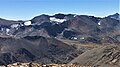 North aspect of Kuna Peak centered in the distance, as seen from Mount Gibbs.
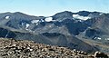 North aspects of Parker Peak (left), Koip Peak (right of center), and Kuna Peak (right) as seen from Mount Gibbs.


References
- "Kuna Peak, California". Peakbagger.com. Retrieved 4 December 2014.
- "Western States Climbers Qualifying Peak List". Climber.org. Retrieved 2016-03-27.
- "Kuna Peak". Geographic Names Information System. United States Geological Survey. Retrieved 4 December 2014.
- Secor, R.J. (2009). The High Sierra Peaks, Passes, and Trails (3rd ed.). Seattle: The Mountaineers. p. 397. ISBN 978-0898869712.
- Gordonye. "Kuna Peak, California, United States, North America". Kuna Peak, California, United States, North America. summitpost.org. Retrieved 6 February 2019.
- "California Thirteeners". Vulgarian Ramblers. Retrieved 14 March 2016.
- "Kuna Peak". SummitPost.org. Retrieved 4 December 2014.
- Kelliher, Mat. "Yosemite NP Peaks". peakbagger.com. Retrieved 24 March 2019.
- Mrchad9. "Yosemite's Highest Peaks". summitpost.org. Retrieved 24 March 2019.
- Farquhar, Francis P. (1926). "Place Names of the High Sierra". Place Names of the High Sierra. yosemite.ca.us. Retrieved 6 February 2019.
- Kroeber, A.L. (2007). "California place names of Indian origin". California place names of Indian origin. archive.org. Retrieved 6 February 2019.
- "Attractions in Kuna Peak". Attractions in Kuna Peak. guroute.com. Retrieved 6 February 2019.
This Mono County, California-related article is a stub. You can help Wikipedia by expanding it. |
This Tuolumne County, California-related article is a stub. You can help Wikipedia by expanding it. |
На других языках
- [en] Kuna Peak
[fr] Pic Kuna
Le pic Kuna (en anglais : Kuna Peak) est un sommet de la Sierra Nevada, aux États-Unis. Il culmine à 3 963 mètres d'altitude à la frontière entre le comté de Mono et le comté de Tuolumne et entre la Yosemite Wilderness du parc national de Yosemite et l'Ansel Adams Wilderness dans la forêt nationale d'Inyo, en Californie.Другой контент может иметь иную лицензию. Перед использованием материалов сайта WikiSort.org внимательно изучите правила лицензирования конкретных элементов наполнения сайта.
WikiSort.org - проект по пересортировке и дополнению контента Википедии