geo.wikisort.org - Mountains
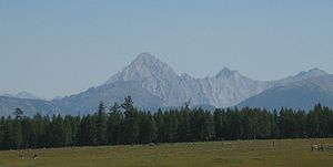
The Khoridol Saridag mountains (Mongolian: Хорьдол Сарьдагийн нуруу, Khoridol Saridagiin nuruu) are a 150 km-long mountain range in Khövsgöl aimag, Mongolia, between Khövsgöl nuur and the Darkhad valley. The range covers parts of the Renchinlkhümbe, Ulaan-Uul and Alag-Erdene sums. The highest peak is Delgerkhaan Uul (3093m), two other notable peaks are Ikh Uul (2961m) and Uran Dösh Uul (2702m) on the shores of Khövsgöl nuur.


The mountains along the lake are rich in phosphorite, and in the 1980s extensive exploration work was done for open-pit mining. Roads built during that time and other remains, are still visible all over the area. However, due to the political and economic changes of the early 1990s in Mongolia and Russia, those projects were cancelled. In 1997, a protected area covering 1886 km2 was founded.
References
- M. Nyamaa, Khövsgöl aimgiin lavlakh toli, Ulaanbaatar 2001, p. 164f
- G. Tseepil, Hovsgol Aimag Map, Ulaanbaatar (?) 2006 (?)
На других языках
- [en] Khoridol Saridag mountains
[ru] Хорьдол-Сарьдаг
Хорьдол-Сарьдаг (монг. Хорьдол Сарьдагийн нуруу) — девяностокилометровый горный массив в аймаке Хувсгел, Монголия, расположенный между озером Хубсугул и Дархадской котловиной. Хребет охватывает сомоны Рэнчинлхумбэ, Улаан-Уул и Алаг-Эрдэнэ. Самый высокий пик — Дэлгэр-Хан-Ула, высотой 3093 м, видимость с вершины которого достигает 20 км. Две другие известные вершины — Их-Ула высотой 2960 м (видимость до 40 км) и Уран-Душ-Ула высотой 2702 м.Другой контент может иметь иную лицензию. Перед использованием материалов сайта WikiSort.org внимательно изучите правила лицензирования конкретных элементов наполнения сайта.
WikiSort.org - проект по пересортировке и дополнению контента Википедии