geo.wikisort.org - Mountains
The Khibiny Mountains (Russian: Хиби́ны [xʲɪˈbʲinɨ]; Kildin Sami: Umptek)[1] is one of the two main mountain ranges of the Kola Peninsula, Russia, within the Arctic Circle, located between Imandra and Umbozero lakes. The range is also known as Khibiny Massif, Khibinsky Mountains, Khibinsky Tundras, Khibins or Khibiny. The Khibiny National Park was set up in 2018.
| Khibiny Mountains | |
|---|---|
| Хиби́ны / Umptek | |
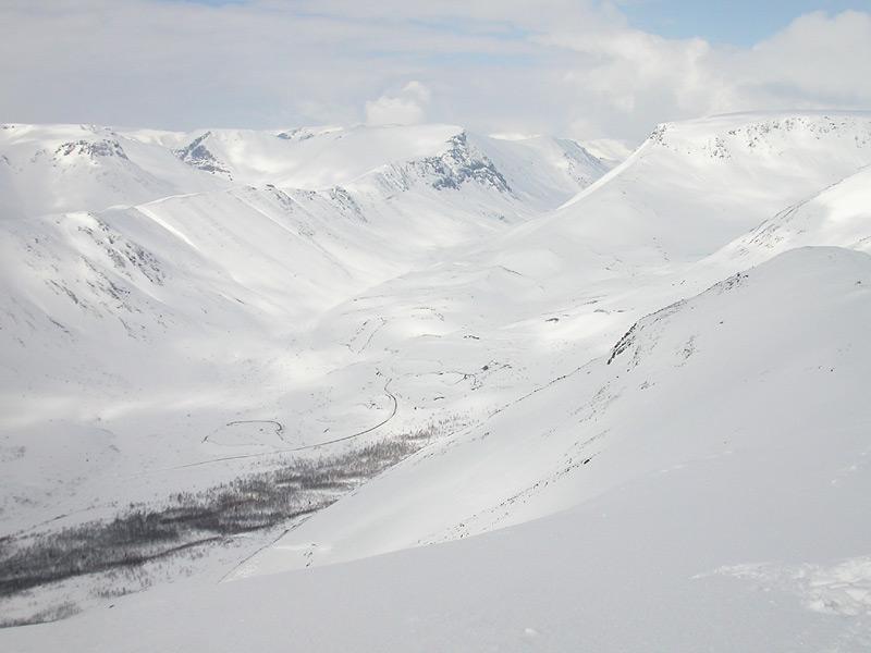 Khibins in winter | |
| Highest point | |
| Peak | Yudychvumchorr |
| Elevation | 1,201 m (3,940 ft) |
| Coordinates | 67°43′21″N 33°28′06″E |
| Dimensions | |
| Area | 1,300 km2 (500 sq mi) |
| Geography | |
 Location in Murmansk Oblast, Russia | |
| Country | Russia |
| Region | Kola Peninsula |
| Range coordinates | 67°44.1′N 33°43.6′E |
Geography


The Khibiny Massif are the highest mountains of the Kola Peninsula, a large peninsula extending from northern Russia into the Barents and White seas. The total land area of the peninsula is approximately 100,000 square kilometres (39,000 sq mi). It is rich in minerals due to the removal of a layer of soil during the last ice age.[2]
The Khibiny Massif is of oval shape of about 1,300 km2. and occupies the central part of the peninsula at a relative elevation of 900–1000 m above the surrounding plain. The mountains are not particularly high; the two highest peaks are the Yudychvumchorr, which stands 1,201 metres (3,940 ft), and the Chasnachorr, which stands 1,191 metres (3,907 ft).[3] The average elevation is 1,116 metres (3,661 ft).[4] The mountains form the shape of a horseshoe topped by a high plateau, drained by a series of deep canyons. The peaks are of plateau type, with steep slopes, with glaciers, icefields and snowfields in some places. The overall terrain is alpine tundra.
The second, and similar mountain range of the Kola Peninsula, the Lovozero Tundras, is located about 5 km east from the easternmost point of Khibiny, separated from it by Lake Umbozero.[2]
The Khibiny range is extremely rich in minerals, mainly apatite and nepheline ores. 477 valid minerals have been reported and 108 of those are type localities or minerals first described in the Khibiny.[5] The range is also seismically active.
Khibiny mountains are mostly uninhabited, except for one of the world's richest mineral quarries. One of the minerals discovered there is reported to have a potential as a nuclear waste radioactivity absorbent.[6] By the foot of the massif the cities of Apatity and Kirovsk are situated.
Climate
Khibiny have an Arctic-moderate climate, with an average winter temperature of −5 °C (23 °F). However, the temperature can potentially drop to −30 °C (−22 °F) during the night. The Gulf Stream, which brings warmer water to the Kolsky Peninsula from the north, moderates the climate, making it slightly warmer than other Arctic regions.[3]
Toponyms in Khibins

- Mount Aikuaiventchorr
- Mount Eveslogchorr
- Hackman Valley
- Kaskasnyunchorr
- Khibinpakhchorr
- Mount Koashkar
- Mount Koashva
- Kuniok Valley
- Mount Maly Mannepakhk
- Mount Kukisvumchorr
- Marchenko Peak
- Mount Rasvumchorr
- Mount Restin'yun
- Mount Yukspor
- Loparskaya Valley
- Mount Nyorkpakhk (Niorkpakhk, N'orkpukhk, N'Yourpakhk)
- Mount Partomchorr
- Petrelius River
- Mount Rischorr
- Mount Takhtarvumchorr
- Tuliylukht Bay
- Vuonnemiok River
- Imandra Lake
- Yum'egor Pass
- Mount Vud'yavrchorr (with botanical garden of polar-alpine flora)
References
- Ферсман А. Е. (1960). Путешествия за камнем. М.: Издательство Академии наук СССР.
- "Mineral Number 27-4". Archived from the original on 2008-04-03. Retrieved 2009-02-16.
- "Khibinsky Mountains". Retrieved 2009-02-16.
- "The Khibiny (Khibinsky tundras)". Archived from the original on 2007-09-28. Retrieved 2009-02-16.
- http://www.mindat.org/loc-2680.html Khibiny Massif, Kola Peninsula, Murmanskaja Oblast', Northern Region, Russia, Mindat.org
- "Safe Nuclear Dump discovered- April 24, 2008". Retrieved 2009-02-16.
External links
 Media related to Khibiny Massif at Wikimedia Commons
- Guide to the Khibiny
- hibiny.info (in Russian)
- Khibiny geology and minerals
Authority control | |
|---|---|
| General |
|
| National libraries | |
На других языках
[de] Chibinen
Die Chibinen[1][2] (russisch Хибины), lange auch unter der kildinsamischen Bezeichnung Umptek bekannt, liegen nördlich des Polarkreises in der Oblast Murmansk auf der Halbinsel Kola in Russland. Sie besitzen bei annähernd kreisförmiger Kontur einen Durchmesser von etwa 45 km und sind das einzige echte Gebirge im europäischen Teil dieses Landes. Die Chibinen entstanden vor rund 362 Millionen Jahren im archaischen Grundgebirge der Halbinsel. Bei ihnen handelt es sich um das größte Nephelinsyenit-Massiv der Erde und die weltweit zweitgrößte Alkaligesteins-Intrusion, die zudem eine außergewöhnliche Vielfalt an Mineralen aufweist. Die höchste Erhebung des Gebirges ist der Judytschwumtschorr mit 1201 m Seehöhe. Auf Grund der nördlichen Lage liegt die Baumgrenze hier schon bei 400 m, darüber folgt die Tundra und schließlich eine polare Steinwüste, die man als Frostschuttwüste bezeichnet.- [en] Khibiny Mountains
[fr] Massif des Khibiny
Le massif des Khibiny, monts Khibiny ou simplement Khibiny (en russe : Хибины) est l'une des deux principales chaînes de montagne de la péninsule de Kola, en Russie. Khibiny désignerait en finnois un sommet plat.[it] Monti Chibiny
I monti Chibiny (in russo: Хибины?; Kildin Sami: Umptek) è una delle due principali catene montuose della penisola di Kola, in Russia, all'interno del Circolo Polare Artico, situata tra i laghi Imandra e Umbozero. La catena è anche conosciuta come Khibiny Massif, Khibinsky Mountains, Khibinsky Tundras, Khibins o Khibiny.[ru] Хибины
Хиби́ны (кильд.-саамск. Умптек[1]) — крупнейший горный массив на Кольском полуострове. Геологический возраст — около 390 млн лет[2]. Вершины платообразные, склоны крутые с отдельными снежниками. Известны 4 небольших ледника общей площадью 0,1 км²[3]. Высшая точка — гора Юдычвумчорр (1200,6 м над уровнем моря). В центре расположены плато Кукисвумчорр и Часначорр.Другой контент может иметь иную лицензию. Перед использованием материалов сайта WikiSort.org внимательно изучите правила лицензирования конкретных элементов наполнения сайта.
WikiSort.org - проект по пересортировке и дополнению контента Википедии