geo.wikisort.org - Mountains
Hamar-Daban (Russian: Хама́р-Даба́н; Buryat: Һамар дабаан, from hамар - "nut", and дабаан, "pass" or "ridge"), is a mountain range in Southern Siberia, Russia.
| Khamar-Daban | |
|---|---|
| Хама́р-Даба́н / Һамар дабаан | |
 Landscape of the range | |
| Highest point | |
| Peak | Utulinskaya Podkova |
| Elevation | 2,396 m (7,861 ft) |
| Dimensions | |
| Length | 420 km (260 mi) E/W |
| Width | 65 km (40 mi) N/S |
| Geography | |
 Location in Buryatia, Far Eastern Federal District, Russia 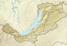 Khamar-Daban (Republic of Buryatia) | |
| Country | Russia |
| Federal subject | Buryatia and Irkutsk Oblast |
| Range coordinates | 51°25′N 104°30′E |
| Parent range | South Siberian System |
| Borders on | Eastern Sayan |
| Geology | |
| Type of rock | Slate, gneiss, basalt, limestone and granite intrusions |
| Climbing | |
| Easiest route | From Gusinoozyorsk |
Geography
The range is located in Buryatia, with a small section in Irkutsk Oblast. It rises near the Baikal Mountains not far from Lake Baikal. It forms a geographic prolongation of the Sayan Mountains.[1] The highest peak is Utulinskaya Podkova at 2,396 m (7,861 ft); 2,090 m (6,860 ft) high Chersky Peak is another important summit.[2] The southern end of the range is part of the Selenga Highlands.[3] The climate of the northern part of the range is affected by Lake Baikal, being temperate and humid, with precipitation up to 1,300 mm per year. The average January temperature is -16-18 °C.[4]

Climate
| Climate data for Khamar-Daban | |||||||||||||
|---|---|---|---|---|---|---|---|---|---|---|---|---|---|
| Month | Jan | Feb | Mar | Apr | May | Jun | Jul | Aug | Sep | Oct | Nov | Dec | Year |
| Record high °C (°F) | 8.7 (47.7) |
8.9 (48.0) |
14.0 (57.2) |
20.4 (68.7) |
27.7 (81.9) |
32.0 (89.6) |
31.5 (88.7) |
30.8 (87.4) |
25.7 (78.3) |
24.2 (75.6) |
13.2 (55.8) |
7.8 (46.0) |
32.0 (89.6) |
| Average high °C (°F) | −11.0 (12.2) |
−9.3 (15.3) |
−4.1 (24.6) |
2.8 (37.0) |
9.8 (49.6) |
16.0 (60.8) |
17.8 (64.0) |
15.9 (60.6) |
10.1 (50.2) |
3.8 (38.8) |
−4.6 (23.7) |
−9.3 (15.3) |
3.2 (37.7) |
| Daily mean °C (°F) | −16.6 (2.1) |
−15.2 (4.6) |
−10.2 (13.6) |
−3.1 (26.4) |
3.9 (39.0) |
10.7 (51.3) |
13.2 (55.8) |
11.3 (52.3) |
4.7 (40.5) |
−2.1 (28.2) |
−10.4 (13.3) |
−14.9 (5.2) |
−2.4 (27.7) |
| Average low °C (°F) | −21.2 (−6.2) |
−20.1 (−4.2) |
−15.3 (4.5) |
−8.3 (17.1) |
−1.3 (29.7) |
5.4 (41.7) |
8.7 (47.7) |
6.8 (44.2) |
0.6 (33.1) |
−6.7 (19.9) |
−15.3 (4.5) |
−19.6 (−3.3) |
−7.2 (19.1) |
| Record low °C (°F) | −38.6 (−37.5) |
−39.6 (−39.3) |
−33.4 (−28.1) |
−28.5 (−19.3) |
−16.4 (2.5) |
−8.3 (17.1) |
−2.0 (28.4) |
−6.2 (20.8) |
−13.0 (8.6) |
−27.2 (−17.0) |
−34.8 (−30.6) |
−37.0 (−34.6) |
−39.6 (−39.3) |
| Average precipitation mm (inches) | 29.3 (1.15) |
27.5 (1.08) |
56.6 (2.23) |
93.7 (3.69) |
124.0 (4.88) |
195.0 (7.68) |
275.4 (10.84) |
229.0 (9.02) |
149.4 (5.88) |
81.3 (3.20) |
56.0 (2.20) |
39.7 (1.56) |
1,356.9 (53.41) |
| Average precipitation days (≥ 0.1 mm) | 13.3 | 11.7 | 13.8 | 15.8 | 15.8 | 17.5 | 19.6 | 19.2 | 15.1 | 13.2 | 14.2 | 14.4 | 183.6 |
| Source: climatebase.ru[5] | |||||||||||||
In popular culture
The song of the same name by Yuri Vizbor, written in 1962, is dedicated to the range.
1993 incident
Six members of a seven-person hiking group led by Lyudmila Korovina died in mysterious circumstances in 1993.[6] Valentina Utochenko was the only survivor.[7] While it was reported that all the victims showed the symptoms of bleeding through their eyes and ears and frothing at the mouth, later autopsy examinations ignored these symptoms and claimed signs of hypothermia and protein deficiency in the deceased members of the hiking group as the cause of death.[8]
See also
- Baikal Nature Reserve
- South Siberian Mountains
References
- Kozhov, M. (11 November 2013). Lake Baikal and Its Life. Springer Science & Business Media. p. 7. ISBN 9789401573887.
- "Природа Байкала - вершина Пик Черского" [The nature of Baikal - the top of Chersky Peak] (in Russian). Archived from the original on 19 April 2021.
- Fadeeva, Natalʹi︠a︡ Vasilʹevna (1963). Селенгинское среднегорье: природные условия и районирование [Selenga Highlands: Natural Conditions and Zoning] (in Russian). Buryat Book Publishing House.
- Sinyukovich, V.N.; Chumakova, E.V. (2009). "Современные особенности гидрометеорологического режима южного побережья оз. Байкал" [Modern features of the hydrometeorological regime of the southern coast of Lake Baikal] (PDF). Bulletin of Irkutsk State University (in Russian). 2 (2): 117–133. Archived from the original (PDF) on 2 October 2013.
- "Khamar-Daban, Russia". Climatebase.ru. Retrieved 17 December 2021.
- Buryatia Incident: Russia's other Dyatlov Pass. 20 November 2019. Archived from the original on 16 January 2021. Retrieved 14 January 2021.
- Varsegova, Natalia (24 July 2018). "Что произошло на бурятском "перевале Дятлова"" [What happened at the Buryat "Dyatlov pass"]. Komsomolskaya Pravda (in Russian). Archived from the original on 2 December 2021. Retrieved 14 January 2021.
- Yegorov, Oleg (25 February 2019). "Beyond the Dyatlov mystery: 2 other creepy tragedies in the Russian mountains". Beyond Russia. Archived from the original on 11 May 2021. Retrieved 14 January 2021.
External links
 Media related to Khamar-Daban at Wikimedia Commons
Authority control | |
|---|---|
| General |
|
| National libraries | |
This Siberian Federal District location article is a stub. You can help Wikipedia by expanding it. |
This Buryatia location article is a stub. You can help Wikipedia by expanding it. |
На других языках
[de] Chamar-Daban
Der Chamar-Daban (russisch Хамар-дабан; auch Chamar-Daban-Gebirge) ist ein maximal 2995 m hohes Hochgebirge südlich des Baikalsees in der Republik Burjatien und in der Oblast Irkutsk im Süden Sibiriens.- [en] Khamar-Daban
[fr] Monts Khamar-Daban
Les monts Khamar-Daban (en russe : Хамар-дабан) sont une chaîne de hautes montagnes située le long de la côte sud-est du lac Baïkal en Russie, dans le sud de la Sibérie, au nord de la frontière mongole. Elle se développe presque totalement en Bouriatie ; seule une petite partie du nord-ouest de la chaîne fait partie du territoire de l'oblast d'Irkoutsk.[it] Monti Chamar-Daban
I monti Chamar-Daban (in russo Хамар-дабан) sono una catena di alte montagne situate lungo la costa sud-orientale del lago Bajkal in Russia, nel sud della Siberia, a nord della frontiera mongola. Si sviluppano quasi completamente in Buriazia; solo una piccola parte del nord-ovest della catena ricade entro i confini dell'oblast' di Irkutsk.[ru] Хамар-Дабан
Хама́р-Даба́н[1] (бур. Хамар дабаан, хамар — «нос» или һамар — «орех», дабаан — «перевал, хребет»[2]) — горный хребет на юге Восточной Сибири в южном Прибайкалье, большей частью в пределах Республики Бурятия, Россия.Другой контент может иметь иную лицензию. Перед использованием материалов сайта WikiSort.org внимательно изучите правила лицензирования конкретных элементов наполнения сайта.
WikiSort.org - проект по пересортировке и дополнению контента Википедии