geo.wikisort.org - Mountains
Kediet ej Jill (Arabic: كدية الجل) is a mountain in Tiris Zemmour, Mauritania, with the city of Zouérat on its east and Fderick at west. At 915 m (3,002 ft) tall, Kediet ej Jill includes the highest peak in Mauritania.
| Kediet ej Jill كدية الجل | |
|---|---|
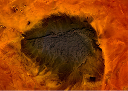 Mt. Kediet ej Jill, Mauritania - seen from space | |
| Highest point | |
| Elevation | 915 m (3,002 ft) |
| Prominence | 596 m (1,955 ft) |
| Listing | Country high point |
| Coordinates | 22°39′04″N 12°34′27″W |
| Geography | |
 Kediet ej Jill كدية الجل Location of Kediet ej Jill in Mauritania | |
| Location | Mauritania |
The mountain and its surrounding area are rich in iron deposits, thought to have been mined here since the 11th century and commercially exploited since 1952. The current mines are connected to Nouadhibou on the Atlantic coast by a 700-km long railway.[1]
The mountain appears bluish because of the high concentration of magnetite, an iron ore and a natural magnet.[2] Owing to its inherent magnetic properties, the mountain disrupts navigational compasses. Similar magnetic fields allowed the discovery of other deposits in the region (magnetite guelbs) in the 1960s.
References
- SNIM, Mauritania, www.mining-technology.com (access: January 25 2017)
- European Space Agency, esa.int (access: August 2 2020)
External links
This article includes a list of references, related reading or external links, but its sources remain unclear because it lacks inline citations. (July 2015) |
- Kediet ej Jill, Tiris Zemmour, Mauritania
- "Kdeyyat ej Joul, Mauritania". Peakbagger.com.
This Mauritania location article is a stub. You can help Wikipedia by expanding it. |
На других языках
[de] Kediet Ijill
Kediet Ijill, auch Kediet ej Jill, ist mit einer Höhe von 915 Metern der höchste Berg Mauretaniens. In der Ebene östlich des Kediet Ijill liegt die Stadt Zouérat,[1] die Hauptstadt der Verwaltungseinheit Tiris Zemmour. Im Westen liegt F’dérik. Die Felsen haben eine blau-graue Farbe, weil das Gestein verschiedene Eisenoxide wie Magnetit enthält.- [en] Kediet ej Jill
[fr] Kedia d'Idjil
Le Kedia d'Idjil (ou Kediet ej Jill) est une montagne située au nord de la Mauritanie, à proximité de la frontière orientale du Sahara occidental, dans la région (wilaya) du Tiris Zemmour. C'est le point culminant du pays.[it] Kediet ej Jill
Il Kediet ej Jill è una montagna dell'Africa occidentale alta 915 metri e che si trova in Mauritania.[ru] Иджиль
Иджи́ль (фр. Kedia d'Idjil) — гора на северо-западе Мавритании в области Тирис-Земмур, недалеко от восточной границы Западной Сахары. Является высшей точкой страны — 917 метров.Другой контент может иметь иную лицензию. Перед использованием материалов сайта WikiSort.org внимательно изучите правила лицензирования конкретных элементов наполнения сайта.
WikiSort.org - проект по пересортировке и дополнению контента Википедии