geo.wikisort.org - Mountains
Kata Tjuṯa / The Olgas (Pitjantjatjara: Kata Tjuṯa, lit. 'many heads'; Aboriginal pronunciation: [kɐtɐ cʊʈɐ]) is a group of large, domed rock formations or bornhardts located about 360 km (220 mi) southwest of Alice Springs, in the southern part of the Northern Territory, central Australia. Uluṟu / Ayers Rock, located 25 km (16 mi) to the east, and Kata Tjuṯa / The Olgas form the two major landmarks within the Uluṟu-Kata Tjuṯa National Park. The park is considered sacred to the Aboriginal people of Australia.[2]: 884
| Kata Tjuṯa / Mount Olga | |
|---|---|
 | |
| Highest point | |
| Peak | Mount Olga |
| Elevation | 1,066 m (3,497 ft)[1] |
| Prominence | 546 m (1,791 ft) |
| Coordinates | 25°18′S 130°44′E |
| Naming | |
| Native name | Kata Tjuṯa (Pitjantjatjara) |
| Geography | |
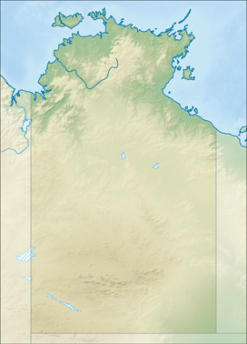 Kata Tjuṯa / Mount Olga Uluṟu-Kata Tjuṯa National Park  Kata Tjuṯa / Mount Olga Kata Tjuṯa / Mount Olga (Australia) | |
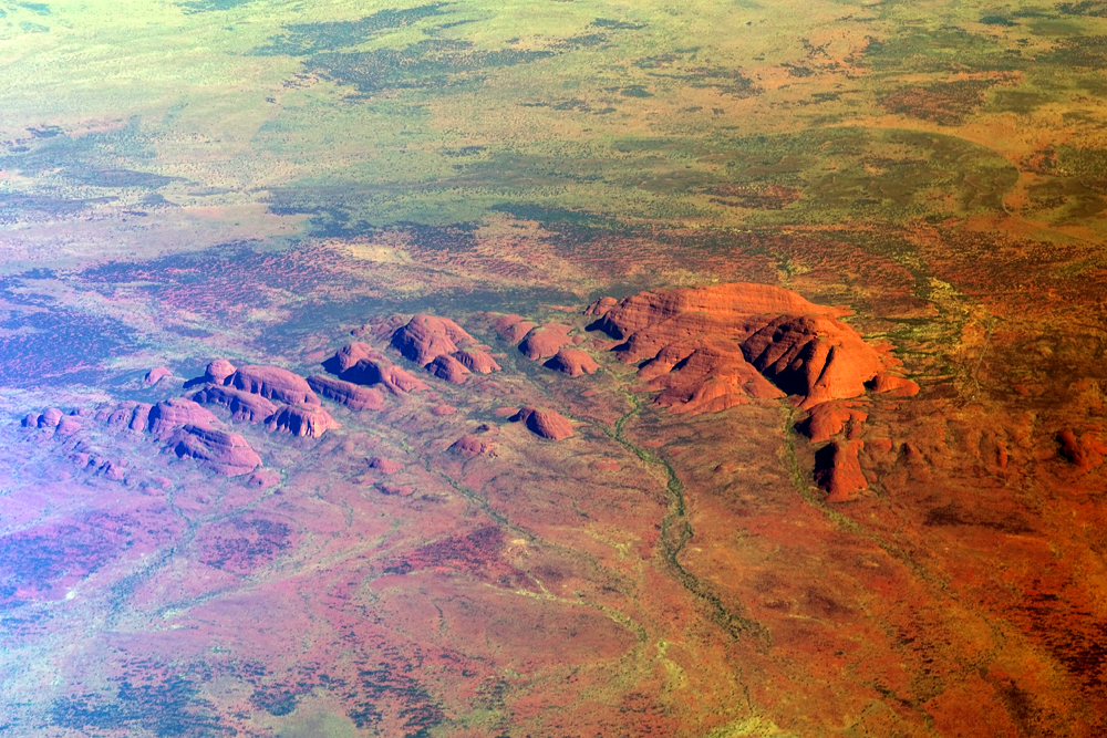
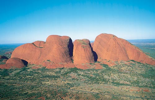
The 36 domes that make up Kata Tjuṯa / Mount Olga cover an area of 21.68 km2 (8.37 sq mi) are composed of conglomerate, a sedimentary rock consisting of cobbles and boulders of varying rock types including granite and basalt, cemented by a matrix of coarse sandstone. The highest dome, Mount Olga, is 1,066 m (3,497 ft) above sea level, or approximately 546 m (1,791 ft) above the surrounding plain (198 m (650 ft) higher than Uluṟu).[1] Kata Tjuṯa is located at the eastern end of the Docker River Road.
Name
The other name, The Olgas, comes from the tallest peak, Mount Olga. At the behest of Baron Ferdinand von Mueller, Mount Olga was named in 1872 by Ernest Giles, in honour of Queen Olga of Württemberg (born Grand Duchess Olga of Russia, daughter of Tsar Nicholas I). She and her husband, King Charles I of Württemberg, had marked their 25th wedding anniversary the previous year by, among other things, naming Mueller a Freiherr (baron), making him Ferdinand von Mueller. The naming was his way of repaying the compliment.[3]
On 15 December 1993, a dual naming policy was adopted that allowed official names consisting of both the traditional Aboriginal name and the English name. As a result, Mount Olga was renamed Mount Olga / Kata Tjuṯa. On 6 November 2002, following a request from the Regional Tourism Association, the order of the dual names was officially reversed, to Kata Tjuṯa / Mount Olga.[4]
Geologic origin
The region surrounding Kata Tjuṯa lies in the Amadeus Basin, an intracratonic basin formed during the Adelaidian, roughly 850–800 million years ago.[5] During the Petermann Orogeny, approximately 550 million years ago, an event known as the Woodroffe Thrust lifted granulite facies rocks northward over low-grade metamorphic rocks. The eventual erosion of the formation resulted in a molasse facies, or deposition in front of rising mountains, in this case, the Petermann Orogeny, creating the deposit known as the Mount Currie Conglomerate. The Mount Currie Conglomerate is made predominately of basalt, porphyry, granite, gneiss and volcanic rock fragments with a matrix composed of angular quartz, microcline and orthoclase among other minerals.[citation needed]
Both Uluṟu / Ayers Rock and the Kata Tjuṯa / Mount Olga are made of sediment originating in this Mount Currie Conglomerate and both have a chemical composition similar to granite. Scientists using Rubidium-strontium dating techniques to date the rock accurately have given it an age of 600 million years, matching the date of the Woodroffe Thrust event. The actual fresh rock that makes up the Kata Tjuṯa / Olgas and Uluṟu / Ayers Rock is medium to dark grey with green or pink hues in some laminae. The bright orange-red hue, for which the structures are noted, is due to a patina over finely divided feldspar coated in iron oxide.[6]
Legends
There are many Pitjantjatjara Dreamtime legends associated with this place and indeed everything in the vicinity including Uluṟu / Ayers Rock. A number of legends surround the great snake king Wanambi, who is said to live on the summit of Kata Tjuṯa / Mount Olga and only comes down during the dry season. His breath was said to be able to transform a breeze into a hurricane in order to punish those who did evil deeds.[7] The majority of mythology surrounding the site is not disclosed to outsiders, and in particular, women. As is the custom, should women become privy to the "men's business", they are susceptible to violent attacks, even death. The Anangu people believe the great rocks of Kata Tjuṯa / Mount Olga are homes to spirit energy from the 'Dreaming', and since 1995 the site is being used once again for cultural ceremonies.[2]: 884–885
Locations, access and facilities
Kata Tjuṯa / Mount Olga can be reached via Ayers Rock Airport, followed by a 55-kilometre (34 mi) drive south, then west. Visitors are required to pay an entry fee.[8] Kata Tjuṯa is about 495 kilometres (308 mi) by road from Alice Springs, via the Stuart and Lasseter highways. It is a 4+1⁄2 hour drive.
Kata Tjuṯa / Mount Olga has both a sunrise and sunset viewing area, which are accessible via a short walk from Kata Tjuṯa Road.[9] There are also two walks that enter the domes of Kata Tjuta:
- Valley of the Winds - 7.4km 7.4 km (4.6 mi) / 3-4 hours (Grade 4)[10][11]
- Walpa Gorge walk - 2.6km 2.6 km (1.6 mi) / 1-2 hours[12]
Gallery
 In the Valley of the Winds walk at Kata Tjuṯa / Mount Olga.
 Kata Tjuṯa / Mount Olga.
 Astronaut photo of Kata Tjuṯa / Mount Olga.
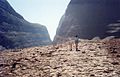 In Uluṟu-Kata Tjuṯa National Park
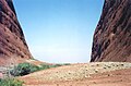 Kata Tjuṯa / Mount Olga, Australia


See also
- Ernest Giles
- Protected areas of the Northern Territory
- Recognition of sacred sites
- Tietkens expedition of 1889
References
- Uluṟu-Kata Tjuṯa National Park Visitors Guide. Retrieved 26 April 2013
- Engels, Christoph (2010). 1000 Sacred Places. Tandem Verlag GmbH.
- Whitlam Institute, University of Western Sydney Archived 2005-07-19 at the Wayback Machine. Retrieved 28 March 2007
- Northern Territory Government — NT Place Names Register. Retrieved 17 November 2007
- "Department of Agriculture, Water and the Environment". Department of Agriculture, Water and the Environment.
- Rowland Twidale, Charles (2010). "33: Uluṟu (Ayers Rock) and Kata Tjuṯa (The Olgas); Inselbergs of Central Australia". Geomorphological Landscapes of the World. Springer. ISBN 9789048130559. ISBN 978-90-481-3054-2
- Scheffel, Richard L.; Wernet, Susan J., eds. (1980). Natural Wonders of the World. United States of America: Reader's Digest Association, Inc. p. 278. ISBN 0-89577-087-3.
- "Passes and permits". Parks Australia. Retrieved 2017-09-28.
- "Sunrise and sunset". Parks Australia. Retrieved 2020-11-01.
- "Valley of the Winds walk". Parks Australia. Retrieved 2020-11-01.
- "Valley of the Winds track notes". Hiking the World. Retrieved 2020-11-02.
- "Walpa Gorge Walk". Parks Australia. Retrieved 2020-11-01.
External links
| Wikimedia Commons has media related to Kata Tjuṯa. |
- Uluṟu-Kata Tjuṯa National Park - Australian Department of the Environment and Water Resources
- A Report on the Uluṟu-Kata Tjuṯa National Park
- Uluṟu-Kata Tjuṯa park on Parks Australia (Australian Government)
На других языках
[de] Kata Tjuṯa
Die Kata Tjuṯa (die Olgas) sind eine Gruppe von 36 Felskuppen in Zentralaustralien etwa 51 Kilometer entfernt von dem Ort Yulara. Gemeinsam mit dem 30 Kilometer entfernten Uluṟu (Ayers Rock) werden sie vom Uluṟu-Kata-Tjuṯa-Nationalpark umschlossen. Der mit 1069 Metern höchste Fels, der Mount Olga, ragt 564 Meter aus der Umgebung heraus.- [en] Kata Tjuta
[es] Kata Tjuṯa
Kata Tjuṯa,[1] también conocido como monte Olga (o coloquialmente como "Las Olgas"), es un grupo de formaciones rocosas situadas a 470 km al suroeste de Alice Springs, en la zona meridional del Territorio del Norte de Australia. Es uno de los principales puntos de interés, junto con Uluṟu, situado a 25 km al este, del parque nacional Uluṟu-Kata Tjuṯa.[fr] Kata Tjuṯa/Monts Olga
Les Kata Tjuta/monts Olga (ou simplement les Olgas) constituent un massif de dômes d'arkoses en inselbergs situés dans le parc national d'Uluṟu-Kata Tjuṯa, à 365 km au sud-ouest d'Alice Springs, en Australie.[it] Kata Tjuta
Kata Tjuṯa, conosciuto anche come Monte Olga (Mount Olga) o Monti Olgas (e colloquialmente come The Olgas), è una grande formazione rocciosa situata nel Parco nazionale Uluru-Kata Tjuta, 465 chilometri a sudovest di Alice Springs, nel Territorio del Nord, in Australia. Kata Tjuṯa si estende per oltre 21 chilometri quadrati e rappresenta uno dei siti più turistici dell'Australia, insieme al vicino monolito Uluru/Ayers Rock, che si trova a 25 chilometri di distanza.[ru] Ката-Тьюта — Ольга
О́лга[4][1][2] (англ. Mount Olga)[1] или Ката-Тьюта — Гора Ольга[5] (англ. Kata Tjuta / Mount Olga[6]) — самая большая вершина в группе из 36 куполообразных скальных образований, высота которой, по одним данным 1066 м[7], по другим — 545,4 м[8]. В переводе с языка коренных жителей (англ. Anangu) Австралии название Ката-Тьюта переводится как «Много голов».Другой контент может иметь иную лицензию. Перед использованием материалов сайта WikiSort.org внимательно изучите правила лицензирования конкретных элементов наполнения сайта.
WikiSort.org - проект по пересортировке и дополнению контента Википедии