geo.wikisort.org - Mountains
Kasprowy Wierch (Polish pronunciation: [kasˈprɔvɨ ˈvjɛrx]; Slovak; Kasprov vrch; sometimes in Kasper Peak)[1] is a peak of a long crest (ridgeline) in the Western Tatras one of Poland's main winter ski areas. Its dominant southern crests, WSW and ESE, mark the border with Slovakia. It is accessible in most conditions by foot and daily by cablecar.
| Kasprowy Wierch | |
|---|---|
| Kasprov vrch Kasper Peak | |
 | |
| Highest point | |
| Elevation | 1,987 m (6,519 ft) |
| Coordinates | 49°13′55″N 19°58′55″E |
| Geography | |
 Kasprowy Wierch Location in Poland | |
| Location | Poland and Slovakia |
| Parent range | Western Tatras |
| Climbing | |
| First ascent | First winter tourist ascent by Poles: Klemens Bachleda and Karol Potkański in c. 1890 |
History

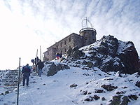
From 1910 onwards Kasprowy Wierch became very popular among ski tourists so much so an aerial tramway or téléphérique, reaching almost to the summit, was built between 1935 and 1936 as such it is one of the oldest in Europe. As part of its modernization, the cabin aerial ropeway was closed for a period until December 2007. In 1938 meteorological and astronomical observatories were built here. One of the faint Kordylewski clouds, at or circling the L4 and L5 Lagrange points of the moon, was first photographed here by Kazimierz Kordylewski in 1961.
Geography
The mountain is at the crossroads of four crests, two of which coincide with footpaths, incorporating steps, bounding Poland and Slovakia and in times without snow the steep paths heading into both countries south and north are quite easily traversable. The slight apex of the four steep crests (peak itself) is just north of the border, which is deemed to be a straight line relative to the two dominant ridges.
Crossing the border between Poland and Slovakia is not restricted, since both countries are members of the Schengen area.[2] Users of the cable car change cars midway in their ascent/descent, at mount Myślenicke Turnie. At the top station is a large restaurant/café/information office building with further ski lifts outside.
The mountain is very popular among hikers from Poland, because of its easy accessibility, both on foot and by the cable car. However, it's much less visited from the Slovak side, because the ascent from the nearest settlement in Slovakia involves a lengthy (17 km) approach up a remote valley Tichá dolina.
Climate
Without the existence of a summer, the climate is of tundra (Köppen: ET), as found in the highest areas of the Alps.[3]
| Climate data for Kasprowy Wierch (ridge), elevation 1,991 m or 6,532 ft, 1991–2020 normals, extremes 1951–present | |||||||||||||
|---|---|---|---|---|---|---|---|---|---|---|---|---|---|
| Month | Jan | Feb | Mar | Apr | May | Jun | Jul | Aug | Sep | Oct | Nov | Dec | Year |
| Record high °C (°F) | 7.2 (45.0) |
9.9 (49.8) |
9.4 (48.9) |
14.2 (57.6) |
18.7 (65.7) |
22.6 (72.7) |
23.4 (74.1) |
22.5 (72.5) |
19.8 (67.6) |
16.9 (62.4) |
13.9 (57.0) |
8.8 (47.8) |
23.4 (74.1) |
| Mean maximum °C (°F) | 3.1 (37.6) |
2.6 (36.7) |
4.1 (39.4) |
8.2 (46.8) |
13.4 (56.1) |
17.9 (64.2) |
19.1 (66.4) |
18.7 (65.7) |
14.4 (57.9) |
11.9 (53.4) |
7.5 (45.5) |
4.6 (40.3) |
20.3 (68.5) |
| Average high °C (°F) | −4.6 (23.7) |
−5.0 (23.0) |
−3.3 (26.1) |
1.2 (34.2) |
6.0 (42.8) |
10.1 (50.2) |
12.1 (53.8) |
12.3 (54.1) |
7.5 (45.5) |
3.9 (39.0) |
0.0 (32.0) |
−3.5 (25.7) |
3.1 (37.6) |
| Daily mean °C (°F) | −7.4 (18.7) |
−7.8 (18.0) |
−6.1 (21.0) |
−1.6 (29.1) |
3.0 (37.4) |
6.7 (44.1) |
8.6 (47.5) |
8.9 (48.0) |
4.6 (40.3) |
1.2 (34.2) |
−2.6 (27.3) |
−6.1 (21.0) |
0.1 (32.2) |
| Average low °C (°F) | −10.1 (13.8) |
−10.5 (13.1) |
−8.7 (16.3) |
−4.0 (24.8) |
0.6 (33.1) |
4.1 (39.4) |
6.0 (42.8) |
6.4 (43.5) |
2.2 (36.0) |
−1.3 (29.7) |
−5.1 (22.8) |
−8.8 (16.2) |
−2.4 (27.7) |
| Mean minimum °C (°F) | −19.2 (−2.6) |
−19.4 (−2.9) |
−16.3 (2.7) |
−12.5 (9.5) |
−6.3 (20.7) |
−2.2 (28.0) |
0.0 (32.0) |
0.1 (32.2) |
−4.1 (24.6) |
−9.8 (14.4) |
−13.7 (7.3) |
−17.6 (0.3) |
−21.9 (−7.4) |
| Record low °C (°F) | −30.2 (−22.4) |
−29.1 (−20.4) |
−27.9 (−18.2) |
−18.1 (−0.6) |
−13.0 (8.6) |
−7.6 (18.3) |
−3.1 (26.4) |
−4.5 (23.9) |
−8.2 (17.2) |
−15.2 (4.6) |
−24.8 (−12.6) |
−28.0 (−18.4) |
−30.2 (−22.4) |
| Average precipitation mm (inches) | 105.1 (4.14) |
98.0 (3.86) |
112.7 (4.44) |
127.3 (5.01) |
186.0 (7.32) |
208.0 (8.19) |
248.1 (9.77) |
171.6 (6.76) |
158.5 (6.24) |
123.4 (4.86) |
117.6 (4.63) |
107.5 (4.23) |
1,763.8 (69.44) |
| Average extreme snow depth cm (inches) | 92.7 (36.5) |
130.5 (51.4) |
153.3 (60.4) |
147.9 (58.2) |
67.9 (26.7) |
14.4 (5.7) |
0.7 (0.3) |
1.2 (0.5) |
9.0 (3.5) |
15.1 (5.9) |
27.2 (10.7) |
56.1 (22.1) |
153.3 (60.4) |
| Average precipitation days (≥ 0.1 mm) | 19.83 | 18.61 | 20.17 | 18.27 | 21.00 | 20.00 | 19.57 | 16.30 | 15.57 | 16.83 | 17.83 | 19.00 | 222.97 |
| Average snowy days (≥ 0 cm) | 31.0 | 28.3 | 30.9 | 30.0 | 20.6 | 3.3 | 0.4 | 0.4 | 5.9 | 13.7 | 21.3 | 30.6 | 216.4 |
| Average relative humidity (%) | 77.6 | 80.5 | 83.8 | 84.3 | 86.8 | 87.7 | 86.6 | 84.5 | 86.2 | 80.9 | 82.0 | 78.6 | 83.3 |
| Mean monthly sunshine hours | 88.9 | 91.2 | 117.1 | 154.1 | 157.5 | 153.8 | 166.5 | 179.3 | 130.8 | 121.3 | 83.8 | 80.7 | 1,524.8 |
| Source 1: Institute of Meteorology and Water Management[4][5][6][7][8][9][10][11] | |||||||||||||
| Source 2: Meteomodel.pl (records, relative humidity 1991–2020)[12][13][14] | |||||||||||||
Cable cars and chairlifts
The cable cars are extremely popular and tourists regularly have to wait up to 3 hours to buy tickets – roughly the same time it would take to ascend the mountain on foot. The cable car service has caused environmental concerns and protests in 1935 and 2006.
In 1961–1962 and in 1967–1968 chairlifts were built on the slopes and they run in two sections.
Gallery
 A weather station on top of Kasprowy Wierch
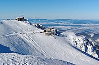 Kasprowy Wierch in winter
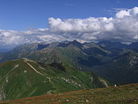 Kasprowy Wierch seen from Malolaczniak
 Kasprowy Wierch cottage
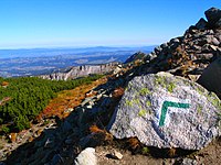 Mountain trail to Kasprowy Wierch


References
- Nuclear Science Abstracts 15(23), 1961, p. 3994.
- Crossing the border on Kasprowy Wierch was strictly prohibited between 1918 (breakup of Austria-Hungary) and 2007 (Poland and Slovakia entering the Schengen Area).
- "Kasprowy Wierch Climate Kasprowy Wierch Temperatures Kasprowy Wierch Weather Averages". www.kasprowy-wierch.climatemps.com. Retrieved 18 July 2019.
- "Średnia dobowa temperatura powietrza". Normy klimatyczne 1991-2020 (in Polish). Institute of Meteorology and Water Management. Archived from the original on 3 December 2021. Retrieved 22 January 2022.
- "Średnia minimalna temperatura powietrza". Normy klimatyczne 1991-2020 (in Polish). Institute of Meteorology and Water Management. Archived from the original on 15 January 2022. Retrieved 22 January 2022.
- "Średnia maksymalna temperatura powietrza". Normy klimatyczne 1991-2020 (in Polish). Institute of Meteorology and Water Management. Archived from the original on 15 January 2022. Retrieved 22 January 2022.
- "Miesięczna suma opadu". Normy klimatyczne 1991-2020 (in Polish). Institute of Meteorology and Water Management. Archived from the original on 9 January 2022. Retrieved 22 January 2022.
- "Liczba dni z opadem >= 0,1 mm". Normy klimatyczne 1991-2020 (in Polish). Institute of Meteorology and Water Management. Archived from the original on 15 January 2022. Retrieved 22 January 2022.
- "Średnia grubość pokrywy śnieżnej". Normy klimatyczne 1991-2020 (in Polish). Institute of Meteorology and Water Management. Archived from the original on 15 January 2022. Retrieved 22 January 2022.
- "Liczba dni z pokrywą śnieżna > 0 cm". Normy klimatyczne 1991-2020 (in Polish). Institute of Meteorology and Water Management. Archived from the original on 15 January 2022. Retrieved 22 January 2022.
- "Średnia suma usłonecznienia (h)". Normy klimatyczne 1991-2020 (in Polish). Institute of Meteorology and Water Management. Archived from the original on 15 January 2022. Retrieved 22 January 2022.
- "Kasprowy Wierch Absolutna temperatura maksymalna" (in Polish). Meteomodel.pl. Retrieved 22 January 2022.
- "Kasprowy Wierch Absolutna temperatura minimalna" (in Polish). Meteomodel.pl. Retrieved 22 January 2022.
- "Kasprowy Wierch Średnia wilgotność" (in Polish). Meteomodel.pl. Retrieved 22 January 2022.
External links
- Zakopane – Kasprowy Wierch webcam
- Kasprowy Wierch cable-car – access information.
| Wikimedia Commons has media related to Kasprowy Wierch. |
| Authority control: National libraries |
|---|
На других языках
[de] Kasprowy Wierch
Der Kasprowy Wierch (Polnisch) bzw. Slowakisch Kasprov vrch, Karpatendeutsch Kasparskogel[1] ist ein 1987 Meter hoher Berg an der polnisch-slowakischen Grenze auf dem Hauptkamm der Tatra in der Westtatra. Er ist einer der vier Hausberge von Zakopane. Seit 1936 befinden sich auf der polnischen Seite des Gipfels eine Seilbahn vom Zakopaner Stadtteil Kuźnice auf den Gipfel und seit 1938 eine meteorologische und eine astronomische Beobachtungsstation. Der Kasprowy Wierch ist der meistbesuchte Gipfel der Westtatra sowie der ganzen Tatra mit pro Saison bis zu 4.000 Personen pro Tag.[2] Aufgrund seiner zentralen Lage und guter Erschließung mit der Seilbahn gilt er als beliebtestes Einfallstor in die Hohe Tatra und Westtatra.- [en] Kasprowy Wierch
[es] Kasprowy Wierch
Cerro Kasprowy (en polaco: Kasprowy Wierch) es un pico ubicado en los Tatras occidentales, que es el límite entre Polonia y Eslovaquia. El pico Kasprovi tiene 1987 metros de altura y es una de las estaciones de esquí más populares de Polonia. Se puede llegar a la cima de Kasprovi en teleférico.[fr] Kasprowy Wierch
Le Kasprowy Wierch (prononciation API : [kasˈprɔvɨ ˈvjɛrx]) en polonais ou Kasprov vrch en slovaque est un sommet des Tatras occidentales sur la frontière entre la Pologne et la Slovaquie. Il culmine à 1 985 ou 1 987 mètres d'altitude.[ru] Каспровы-Верх
Каспровы-Верх (польск. Kasprowy Wierch) / Каспров-Врх (словацк. Kasprov vrch) — одна из вершин в Западных Татрах. Высота горы — 1970 метров над уровнем моря. Она расположена на границе Польши и Словакии.Другой контент может иметь иную лицензию. Перед использованием материалов сайта WikiSort.org внимательно изучите правила лицензирования конкретных элементов наполнения сайта.
WikiSort.org - проект по пересортировке и дополнению контента Википедии